TopoQuest Logo
Do you find TopoQuest useful?
Help keep TopoQuest running and adding new maps/features by donating!
Bitcoin:  19c7KJd3qBynnjoSw5npx9KScwjBe4ifkT
Litecoin:  LXs6TkuXGGXo1vDsWCkWVdjQX94eUKd6ui
Home View Maps Find Maps Find Places Resources & Links


Wallace, Indiana Topographic Map

USGS Map Title: Wallace, IN
USGS Map MRC: 39087H2
DRG (GeoTIFF) Download: o39087h2.tif


Neighboring USGS Topographic Map Quads:


  Veedersburg, IN  
40087A3
 

  Hillsboro, IN  
40087A2
 

  Waynetown, IN  
40087A1
 

  Kingman, IN  
39087H3
 

  Wallace, IN  
39087H2
 

  Alamo, IN  
39087H1
 

  Montezuma, IN  
39087G3
 

  Rockville, IN  
39087G2
 

  Bellmore, IN  
39087G1


Map MRC Location:

N40°
W88°
N40°
W87°
H8 H7 H6 H5 H4 H3 H2 H1
G8 G7 G6 G5 G4 G3 G2 G1
F8 F7 F6 F5 F4 F3 F2 F1
E8 E7 E6 E5 E4 E3 E2 E1
D8 D7 D6 D5 D4 D3 D2 D1
C8 C7 C6 C5 C4 C3 C2 C1
B8 B7 B6 B5 B4 B3 B2 B1
A8 A7 A6 A5 A4 A3 A2 A1
N39°
W88°
N39°
W87°

Wallace, IN USGS 1:24K Topographic Map Preview:
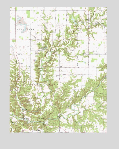
Wallace, IN USGS Topographic Map
Click on map above to begin viewing in our Map Viewer.

This topographic map contains these locations and features:
Feature Name Type Latitude Longitude GNIS ID View Map
Buffalo BranchStreamN39.9550°W87.1972°431771View Map
Buffalo CreekStreamN39.9595°W87.1964°431774View Map
Camp GulickParkN39.9145°W87.1389°432036View Map
Cashatt CemeteryCemeteryN39.9098°W87.2153°432212View Map
Cornstalk (historical)LocaleN39.8939°W87.1595°452170View Map
Cox Ford Covered BridgeBridgeN39.8853°W87.2239°433069View Map
East Prong Green CreekStreamN39.9148°W87.2397°433925View Map
Freedom ChurchChurchN39.9964°W87.1917°452243View Map
Friends Union ChurchChurchN39.9317°W87.1856°434855View Map
Grange CornerPopulated PlaceN39.9400°W87.1858°435312View Map
Grange Corner Covered Bridge (historical)BridgeN39.9398°W87.2086°435313View Map
Green CreekStreamN39.8989°W87.2333°449075View Map
Hemlock LakesReservoirN39.9876°W87.1681°452051View Map
Hemlock Lakes Dam NorthDamN39.9850°W87.1667°448643View Map
Hemlock Lakes Dam SouthDamN39.9834°W87.1633°448768View Map
Jungle ParkParkN39.8881°W87.2306°437145View Map
Keller BranchStreamN39.9020°W87.1611°437207View Map
Lick BranchStreamN39.9906°W87.1697°437851View Map
Lusk ChapelChurchN39.9034°W87.1945°438411View Map
Lusks Mills (historical)Populated PlaceN39.8939°W87.1814°452171View Map
Lusks Springs (historical)SpringN39.8939°W87.1814°448360View Map
Maxwell BranchStreamN39.9125°W87.1358°438754View Map
Maxwell BranchStreamN39.9242°W87.1331°448359View Map
Middle Prong Green CreekStreamN39.9195°W87.2367°439108View Map
Montgomery BranchStreamN39.9225°W87.1342°439360View Map
NarrowsGapN39.8903°W87.1878°439938View Map
Narrows BridgeBridgeN39.8909°W87.1853°1789053View Map
Nolen CemeteryCemeteryN39.9781°W87.1636°440197View Map
North Hemlock LakeReservoirN39.9850°W87.1667°448644View Map
Painter LakeReservoirN39.9596°W87.2037°448641View Map
Painter Lake DamDamN39.9584°W87.2033°448642View Map
Panther CreekStreamN39.9503°W87.1995°440853View Map
Phanuel ChurchChurchN39.9828°W87.1317°441075View Map
Rocky HollowValleyN39.8893°W87.2001°442233View Map
RussellvilleLocaleN39.9262°W87.2036°449855View Map
Russellville Post Office (historical)Post OfficeN39.9262°W87.2036°453011View Map
South Hemlock LakeReservoirN39.9838°W87.1655°448767View Map
Stillwater CreekStreamN39.9839°W87.1445°444165View Map
Sugar Mill CreekStreamN39.8889°W87.2345°444353View Map
Terre Haute Boys Club LakeReservoirN39.9134°W87.1400°447616View Map
Terre Haute Boys Club Lake DamDamN39.9134°W87.1400°447617View Map
Town of WallaceCivilN39.9875°W87.1480°2397719View Map
Township of HowardCivilN39.9037°W87.1327°453420View Map
Township of JacksonCivilN39.9963°W87.1480°453444View Map
Township of Sugar CreekCivilN39.9226°W87.2075°453884View Map
Turkey RunStreamN39.8850°W87.2078°444983View Map
Turkey Run Elementary SchoolSchoolN39.8767°W87.2122°447190View Map
Turkey Run High SchoolSchoolN39.8767°W87.2122°444984View Map
Turkey Run State ParkParkN39.8900°W87.1950°444985View Map
WallacePopulated PlaceN39.9864°W87.1483°445387View Map
Wallace Volunteer Fire DepartmentBuildingN39.9868°W87.1488°2625794View Map
Wapalo CreekStreamN39.8923°W87.1692°445461View Map
Welchel BranchStreamN39.9178°W87.1414°445657View Map
West Prong Green CreekStreamN39.9148°W87.2397°445805View Map
Wilkins Mill Covered BridgeBridgeN39.8984°W87.2331°446040View Map
Wilson AirportAirportN39.9813°W87.1807°2676938View Map
Wolf CreekStreamN39.9578°W87.1806°446239View Map
Wolf Creek ChurchChurchN39.9525°W87.1547°446247View Map
Zackmire CemeteryCemeteryN39.9544°W87.1940°446423View Map

Note: Coordinates in the location and feature list above are referenced to NAD83 datum.


Copyright (C) 2008-2024 Ryan Niemi / Sunset Dynamics ... All Rights Reserved