TopoQuest Logo
Do you find TopoQuest useful?
Help keep TopoQuest running and adding new maps/features by donating!
Bitcoin:  19c7KJd3qBynnjoSw5npx9KScwjBe4ifkT
Litecoin:  LXs6TkuXGGXo1vDsWCkWVdjQX94eUKd6ui
Home View Maps Find Maps Find Places Resources & Links


Monterey, Virginia Topographic Map

USGS Map Title: Monterey, VA
USGS Map MRC: 38079D5
DRG (GeoTIFF) Download: o38079d5.tif


Neighboring USGS Topographic Map Quads:


  Thornwood, WV  
38079E6
 

  Snowy Mountain, WV  
38079E5
 

  Moatstown, WV  
38079E4
 

  Hightown, VA  
38079D6
 

  Monterey, VA  
38079D5
 

  Doe Hill, VA  
38079D4
 

  Mustoe, VA  
38079C6
 

  Monterey SE, VA  
38079C5
 

  McDowell, VA  
38079C4


Map MRC Location:

N39°
W80°
N39°
W79°
H8 H7 H6 H5 H4 H3 H2 H1
G8 G7 G6 G5 G4 G3 G2 G1
F8 F7 F6 F5 F4 F3 F2 F1
E8 E7 E6 E5 E4 E3 E2 E1
D8 D7 D6 D5 D4 D3 D2 D1
C8 C7 C6 C5 C4 C3 C2 C1
B8 B7 B6 B5 B4 B3 B2 B1
A8 A7 A6 A5 A4 A3 A2 A1
N38°
W80°
N38°
W79°

Monterey, VA USGS 1:24K Topographic Map Preview:
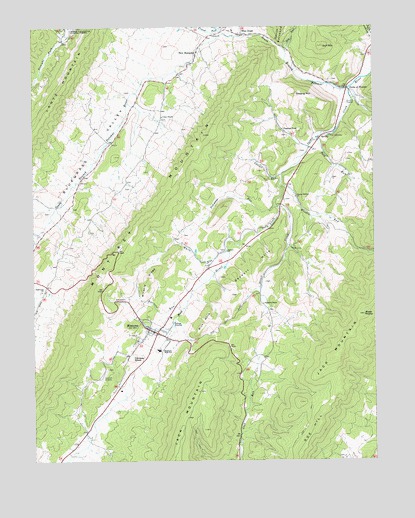
Monterey, VA USGS Topographic Map
Click on map above to begin viewing in our Map Viewer.

This topographic map contains these locations and features:
Feature Name Type Latitude Longitude GNIS ID View Map
Asbury ChurchChurchN38.4354°W79.5534°1481345View Map
Barren RockSummitN38.4173°W79.5037°1486630View Map
Blue Grass Post OfficePost OfficeN38.4986°W79.5515°2766340View Map
Blue Grass School (historical)SchoolN38.4993°W79.5509°1673765View Map
Burners RunStreamN38.4193°W79.5692°1482176View Map
Central ChurchChurchN38.4982°W79.5564°1482434View Map
Doe HillSummitN38.3871°W79.5203°1495470View Map
Elk RunStreamN38.4935°W79.5314°1483281View Map
Forks of WatersLocaleN38.4823°W79.5087°1483492View Map
Frank RunStreamN38.4982°W79.5528°1483527View Map
Ginseng MountainSummitN38.4807°W79.5275°1483647View Map
Gulf MountainSummitN38.4946°W79.5175°1483860View Map
Hannah FieldAirportN38.3985°W79.6008°1488515View Map
Highland County Sheriff's OfficeBuildingN38.4125°W79.5822°2766956View Map
Highland County Volunteer Fire DepartmentBuildingN38.4126°W79.5786°2075350View Map
Highland County Volunteer Rescue SquadBuildingN38.4127°W79.5759°2075351View Map
Highland Elementary SchoolSchoolN38.4074°W79.5796°1673775View Map
Highland High SchoolSchoolN38.4071°W79.5786°1484097View Map
Hightown ChurchChurchN38.4240°W79.6217°1484101View Map
Key RunStreamN38.4976°W79.5439°1484574View Map
Lantz MountainSummitN38.4812°W79.6145°1484664View Map
Laurel RunStreamN38.4571°W79.5331°1484722View Map
Miracle RidgeRidgeN38.4282°W79.5834°1485495View Map
MontereyPopulated PlaceN38.4123°W79.5806°1498517View Map
Monterey Methodist Episcopal ChurchChurchN38.4118°W79.5795°1673777View Map
Monterey MountainSummitN38.4210°W79.6062°1485521View Map
Monterey Post OfficePost OfficeN38.4115°W79.5784°2766253View Map
New HampdenPopulated PlaceN38.4929°W79.5634°1496000View Map
Peck RunStreamN38.4685°W79.5192°1486118View Map
Possum TrotPopulated PlaceN38.4701°W79.5323°1496110View Map
Rich HillsSummitN38.4148°W79.5600°1496144View Map
Seybert ChapelChurchN38.4201°W79.5403°1487013View Map
Seybert HillsSummitN38.4312°W79.5425°1496194View Map
Simmons RunStreamN38.4485°W79.5359°1487250View Map
Strait CreekStreamN38.4823°W79.5087°1487661View Map
Strait Creek School (historical)SchoolN38.4132°W79.5381°1673781View Map
Thorny Bottom ChurchChurchN38.4512°W79.5281°1487894View Map
Town of MontereyCivilN38.4116°W79.5809°2391311View Map
Trimble KnobSummitN38.4048°W79.5881°1496326View Map
Union ChapelChurchN38.4746°W79.5764°1488054View Map
West Strait CreekStreamN38.4482°W79.5345°1488259View Map
White RunStreamN38.4362°W79.5537°1488320View Map
Wooden RunStreamN38.4551°W79.5337°1488473View Map

Note: Coordinates in the location and feature list above are referenced to NAD83 datum.


Copyright (C) 2008-2024 Ryan Niemi / Sunset Dynamics ... All Rights Reserved