TopoQuest Logo
Do you find TopoQuest useful?
Help keep TopoQuest running and adding new maps/features by donating!
Bitcoin:  19c7KJd3qBynnjoSw5npx9KScwjBe4ifkT
Litecoin:  LXs6TkuXGGXo1vDsWCkWVdjQX94eUKd6ui
Home View Maps Find Maps Find Places Resources & Links


Madden, Mississippi Topographic Map

USGS Map Title: Madden, MS
USGS Map MRC: 32089F3
DRG (GeoTIFF) Download: o32089f3.tif


Neighboring USGS Topographic Map Quads:


  Renfroe, MS  
32089G4
 

  Edinburg, MS  
32089G3
 

  Pearl River, MS  
32089G2
 

  McAfee, MS  
32089F4
 

  Madden, MS  
32089F3
 

  McDonald, MS  
32089F2
 

  Walnut Grove, MS  
32089E4
 

  Sebastopol, MS  
32089E3
 

  Union West, MS  
32089E2


Map MRC Location:

N33°
W90°
N33°
W89°
H8 H7 H6 H5 H4 H3 H2 H1
G8 G7 G6 G5 G4 G3 G2 G1
F8 F7 F6 F5 F4 F3 F2 F1
E8 E7 E6 E5 E4 E3 E2 E1
D8 D7 D6 D5 D4 D3 D2 D1
C8 C7 C6 C5 C4 C3 C2 C1
B8 B7 B6 B5 B4 B3 B2 B1
A8 A7 A6 A5 A4 A3 A2 A1
N32°
W90°
N32°
W89°

Madden, MS USGS 1:24K Topographic Map Preview:
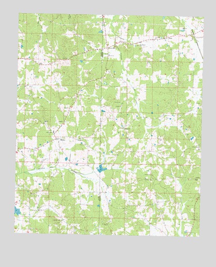
Madden, MS USGS Topographic Map
Click on map above to begin viewing in our Map Viewer.

This topographic map contains these locations and features:
Feature Name Type Latitude Longitude GNIS ID View Map
Carolina CemeteryCemeteryN32.7007°W89.3059°668073View Map
Carolina ChurchChurchN32.6985°W89.3062°668074View Map
Cherry ChapelChurchN32.7215°W89.3609°668365View Map
Dixon Volunteer Fire Department Station 2BuildingN32.6258°W89.2578°2665793View Map
DowdvillePopulated PlaceN32.6860°W89.3037°669367View Map
H Pilgrim Lake DamDamN32.7418°W89.2634°681618View Map
Hope Volunteer Fire Department Station 2BuildingN32.7338°W89.3156°2665839View Map
Laurel HillPopulated PlaceN32.7312°W89.3165°672323View Map
Laurel Hill CemeteryCemeteryN32.7276°W89.3137°707207View Map
Laurel Hill ChurchChurchN32.7276°W89.3153°672326View Map
Leake AcademySchoolN32.6826°W89.3503°672341View Map
MaddenPopulated PlaceN32.6790°W89.3481°673050View Map
Madden Baptist ChurchChurchN32.6829°W89.3492°707119View Map
Madden High SchoolSchoolN32.6821°W89.3495°707120View Map
Madden Methodist ChurchChurchN32.6824°W89.3492°707121View Map
Madden Post OfficePost OfficeN32.6788°W89.3481°2768798View Map
Madden Volunteer Fire DepartmentBuildingN32.6735°W89.3734°2665851View Map
Mount Bethany CemeteryCemeteryN32.6574°W89.2831°673927View Map
Mount Bethany ChurchChurchN32.6604°W89.2842°673928View Map
Mount Zion CemeteryCemeteryN32.6379°W89.3592°707126View Map
Mount Zion ChurchChurchN32.6382°W89.3590°674361View Map
New Bethel ChurchChurchN32.7376°W89.2834°674577View Map
New Prospect ChurchChurchN32.7329°W89.2945°674804View Map
Old Arbor Mount Zion ChurchChurchN32.6324°W89.3426°675159View Map
Pine Grove ChurchChurchN32.6762°W89.3287°675843View Map
Prairie ChapelChurchN32.6579°W89.2537°676301View Map
Providence Baptist ChurchChurchN32.6307°W89.3123°676380View Map
W C Majors Pond DamDamN32.6668°W89.3401°681568View Map
WaldoPopulated PlaceN32.7374°W89.2770°692301View Map
Williamsburg (historical)LocaleN32.6515°W89.3265°685009View Map
Zion (historical)LocaleN32.6390°W89.3584°707181View Map
Zion ChurchChurchN32.6396°W89.3587°679997View Map

Note: Coordinates in the location and feature list above are referenced to NAD83 datum.


Copyright (C) 2008-2024 Ryan Niemi / Sunset Dynamics ... All Rights Reserved