TopoQuest Logo
Do you find TopoQuest useful?
Help keep TopoQuest running and adding new maps/features by donating!
Bitcoin:  19c7KJd3qBynnjoSw5npx9KScwjBe4ifkT
Litecoin:  LXs6TkuXGGXo1vDsWCkWVdjQX94eUKd6ui
Home View Maps Find Maps Find Places Resources & Links


Lowville, New York Topographic Map

USGS Map Title: Lowville, NY
USGS Map MRC: 43075G4
DRG (GeoTIFF) Download: o43075g4.tif


Neighboring USGS Topographic Map Quads:


  Carthage, NY  
43075H5
 

  Croghan, NY  
43075H4
 

  Belfort, NY  
43075H3
 

  West Lowville, NY  
43075G5
 

  Lowville, NY  
43075G4
 

  Crystal Dale, NY  
43075G3
 

  Page, NY  
43075F5
 

  Glenfield, NY  
43075F4
 

  Brantingham, NY  
43075F3


Map MRC Location:

N44°
W76°
N44°
W75°
H8 H7 H6 H5 H4 H3 H2 H1
G8 G7 G6 G5 G4 G3 G2 G1
F8 F7 F6 F5 F4 F3 F2 F1
E8 E7 E6 E5 E4 E3 E2 E1
D8 D7 D6 D5 D4 D3 D2 D1
C8 C7 C6 C5 C4 C3 C2 C1
B8 B7 B6 B5 B4 B3 B2 B1
A8 A7 A6 A5 A4 A3 A2 A1
N43°
W76°
N43°
W75°

Lowville, NY USGS 1:24K Topographic Map Preview:
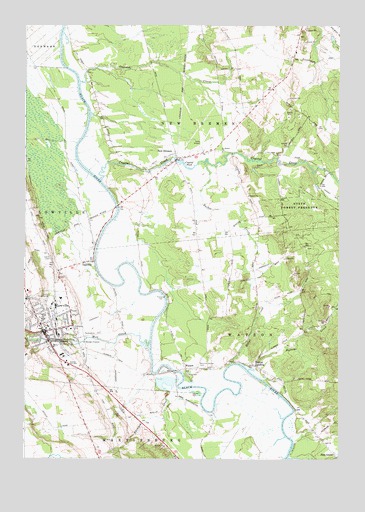
Lowville, NY USGS Topographic Map
Click on map above to begin viewing in our Map Viewer.

This topographic map contains these locations and features:
Feature Name Type Latitude Longitude GNIS ID View Map
Beaches Bridge CemeteryCemeteryN43.7771°W75.4315°943225View Map
Brookside Senior Living CommunityBuildingN43.7865°W75.4734°2614600View Map
Bushes LandingPopulated PlaceN43.7776°W75.4091°945315View Map
Butler CreekStreamN43.8356°W75.4285°945343View Map
Capidon CreekStreamN43.8587°W75.4780°945805View Map
Central SchoolSchoolN43.7903°W75.4916°946316View Map
Crystal CreekStreamN43.8303°W75.4696°947892View Map
Crystal PondLakeN43.8351°W75.4375°947907View Map
DadvillePopulated PlaceN43.8067°W75.4746°947986View Map
Duflo AirportAirportN43.8407°W75.4297°978165View Map
Ebblie CemeteryCemeteryN43.8078°W75.4897°949326View Map
Harvey CreekStreamN43.7756°W75.4110°970193View Map
Hodge CreekStreamN43.7776°W75.4177°952916View Map
Lewis CountyCivilN43.7847°W75.4488°974123View Map
Lewis County General HospitalHospitalN43.7955°W75.4995°2614545View Map
Lewis County General Hospital Residential Health Care FacilityBuildingN43.7954°W75.4998°2614703View Map
Lewis County Search and Rescue Ambulance ServiceBuildingN43.7944°W75.4993°2720096View Map
Lowcille United Methodist ChurchChurchN43.7875°W75.4914°2616676View Map
LowvillePopulated PlaceN43.7867°W75.4919°956123View Map
Lowville Baptist ChurchChurchN43.7875°W75.4933°2616677View Map
Lowville Elementary SchoolSchoolN43.7907°W75.4927°2668875View Map
Lowville High SchoolSchoolN43.7896°W75.4929°2669226View Map
Lowville Middle SchoolSchoolN43.7903°W75.4918°2669171View Map
Lowville Presbyterian ChurchChurchN43.7914°W75.4960°2616678View Map
Lowville Volunteer Fire DepartmentBuildingN43.7875°W75.4940°2718496View Map
Mill CreekStreamN43.7823°W75.4505°957244View Map
New BremenPopulated PlaceN43.8378°W75.4402°958394View Map
New Bremen Fire DepartmentBuildingN43.8349°W75.4415°2718331View Map
Pine GrovePopulated PlaceN43.7517°W75.3768°972945View Map
Rainbow CreekStreamN43.7703°W75.4388°962143View Map
Rhema FellowshipChurchN43.7846°W75.4825°2616831View Map
Ross FarmsLocaleN43.7783°W75.4750°2703221View Map
Saint Peter's Catholic ChurchChurchN43.7875°W75.4898°2617015View Map
Saint Peters Catholic SchoolSchoolN43.7881°W75.4905°2669097View Map
Saint Peters ChurchChurchN43.8387°W75.4216°964158View Map
The Church of Jesus Christ of Latter Day SaintsChurchN43.7953°W75.4815°2616332View Map
Trinity Episcopal ChurchChurchN43.7887°W75.4933°2616386View Map
Tucker School (historical)SchoolN43.7708°W75.3972°2519082View Map
Village of LowvilleCivilN43.7867°W75.4874°2390950View Map
WatsonPopulated PlaceN43.7759°W75.4360°968923View Map

Note: Coordinates in the location and feature list above are referenced to NAD83 datum.


Copyright (C) 2008-2024 Ryan Niemi / Sunset Dynamics ... All Rights Reserved