TopoQuest Logo
Do you find TopoQuest useful?
Help keep TopoQuest running and adding new maps/features by donating!
Bitcoin:  19c7KJd3qBynnjoSw5npx9KScwjBe4ifkT
Litecoin:  LXs6TkuXGGXo1vDsWCkWVdjQX94eUKd6ui
Home View Maps Find Maps Find Places Resources & Links


Crystal Dale, New York Topographic Map

USGS Map Title: Crystal Dale, NY
USGS Map MRC: 43075G3
DRG (GeoTIFF) Download: o43075g3.tif


Neighboring USGS Topographic Map Quads:


  Croghan, NY  
43075H4
 

  Belfort, NY  
43075H3


  Lowville, NY  
43075G4
 

  Crystal Dale, NY  
43075G3


  Glenfield, NY  
43075F4
 

  Brantingham, NY  
43075F3


Map MRC Location:

N44°
W76°
N44°
W75°
H8 H7 H6 H5 H4 H3 H2 H1
G8 G7 G6 G5 G4 G3 G2 G1
F8 F7 F6 F5 F4 F3 F2 F1
E8 E7 E6 E5 E4 E3 E2 E1
D8 D7 D6 D5 D4 D3 D2 D1
C8 C7 C6 C5 C4 C3 C2 C1
B8 B7 B6 B5 B4 B3 B2 B1
A8 A7 A6 A5 A4 A3 A2 A1
N43°
W76°
N43°
W75°

Crystal Dale, NY USGS 1:24K Topographic Map Preview:
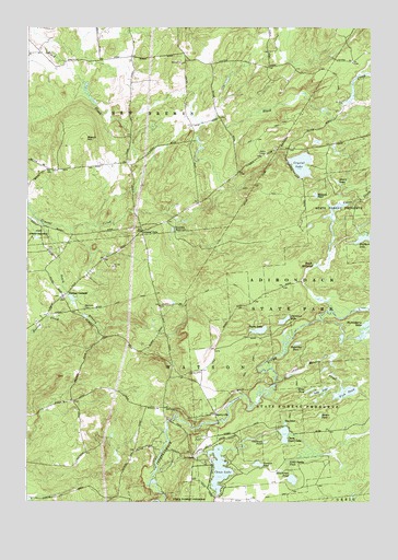
Crystal Dale, NY USGS Topographic Map
Click on map above to begin viewing in our Map Viewer.

This topographic map contains these locations and features:
Feature Name Type Latitude Longitude GNIS ID View Map
Beach MillpondLakeN43.8124°W75.2698°969845View Map
Beaver Meadow CreekStreamN43.7812°W75.2843°943411View Map
Beech HillSummitN43.8459°W75.3541°943509View Map
Beech Hill School (historical)SchoolN43.8375°W75.3658°2519085View Map
Burnt CreekStreamN43.8006°W75.2655°945243View Map
Calfhead PondLakeN43.7660°W75.2879°945455View Map
Campville CemeteryCemeteryN43.8009°W75.3541°970957View Map
Chase LakeLakeN43.7590°W75.3048°946432View Map
Chase Upper LakeLakeN43.7679°W75.2810°946439View Map
Cleveland LakeLakeN43.7979°W75.2814°946856View Map
Crystal DalePopulated PlaceN43.8215°W75.3330°972354View Map
Crystal LakeLakeN43.8390°W75.2752°947903View Map
Crystal Lake School (historical)SchoolN43.8431°W75.2794°2519088View Map
Dicob School (historical)SchoolN43.8542°W75.3064°2519087View Map
Evies PondLakeN43.7795°W75.2721°949780View Map
Fish PondLakeN43.7790°W75.2593°950149View Map
Gourd LakeLakeN43.8341°W75.2615°951422View Map
Halfmoon LakeLakeN43.8194°W75.2532°952028View Map
Hinchings PondLakeN43.7561°W75.2781°952876View Map
Hopsicker PondLakeN43.7918°W75.2765°953205View Map
Huckleberry LakeLakeN43.7941°W75.2515°953371View Map
Little Punky PondLakeN43.7606°W75.2796°955645View Map
Long LakeLakeN43.7794°W75.2680°955874View Map
Lowville ReservoirReservoirN43.8217°W75.3220°956124View Map
Mahan PondLakeN43.7729°W75.2681°956271View Map
Ossoit School (historical)SchoolN43.8219°W75.3667°2519084View Map
Parsons PondLakeN43.7601°W75.2908°959949View Map
Payne LakeLakeN43.7953°W75.2903°960014View Map
Petries CornersPopulated PlaceN43.8042°W75.3616°960255View Map
Petries Mill (historical)LocaleN43.8550°W75.2597°2519089View Map
Puffer School (historical)SchoolN43.7764°W75.3575°2519083View Map
South Branch Crystal CreekStreamN43.8228°W75.3688°965693View Map
SperryvillePopulated PlaceN43.7731°W75.3066°973105View Map
Stewart PondLakeN43.8308°W75.2698°966414View Map
Strifts School (historical)SchoolN43.8672°W75.3372°2519086View Map
The InletLakeN43.7706°W75.2807°967269View Map
Town of New BremenCivilN43.8588°W75.3726°979257View Map
Town of WatsonCivilN43.8241°W75.2545°979607View Map

Note: Coordinates in the location and feature list above are referenced to NAD83 datum.


Copyright (C) 2008-2024 Ryan Niemi / Sunset Dynamics ... All Rights Reserved