TopoQuest Logo
Do you find TopoQuest useful?
Help keep TopoQuest running and adding new maps/features by donating!
Bitcoin:  19c7KJd3qBynnjoSw5npx9KScwjBe4ifkT
Litecoin:  LXs6TkuXGGXo1vDsWCkWVdjQX94eUKd6ui
Home View Maps Find Maps Find Places Resources & Links


Lockwood, Missouri Topographic Map

USGS Map Title: Lockwood, MO
USGS Map MRC: 37093D8
DRG (GeoTIFF) Download: o37093d8.tif


Neighboring USGS Topographic Map Quads:


  Jerico Springs, MO  
37094E1
 

  Cedarville, MO  
37093E8
 

  Crisp, MO  
37093E7
 

  Golden City, MO  
37094D1
 

  Lockwood, MO  
37093D8
 

  Greenfield, MO  
37093D7
 

  Dudenville, MO  
37094C1
 

  Kings Point, MO  
37093C8
 

  South Greenfield, MO  
37093C7


Map MRC Location:

N38°
W94°
N38°
W93°
H8 H7 H6 H5 H4 H3 H2 H1
G8 G7 G6 G5 G4 G3 G2 G1
F8 F7 F6 F5 F4 F3 F2 F1
E8 E7 E6 E5 E4 E3 E2 E1
D8 D7 D6 D5 D4 D3 D2 D1
C8 C7 C6 C5 C4 C3 C2 C1
B8 B7 B6 B5 B4 B3 B2 B1
A8 A7 A6 A5 A4 A3 A2 A1
N37°
W94°
N37°
W93°

Lockwood, MO USGS 1:24K Topographic Map Preview:
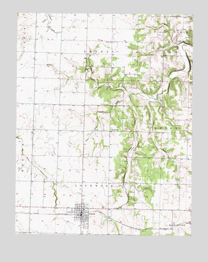
Lockwood, MO USGS Topographic Map
Click on map above to begin viewing in our Map Viewer.

This topographic map contains these locations and features:
Feature Name Type Latitude Longitude GNIS ID View Map
Carson BranchStreamN37.4831°W93.8874°715438View Map
Chalk Level School (historical)SchoolN37.4417°W93.9744°746272View Map
City of LockwoodCivilN37.3867°W93.9579°2395742View Map
Collins CemeteryCemeteryN37.4489°W93.9388°716128View Map
Coose FieldAirportN37.3950°W93.9588°2770276View Map
DumbeckLocaleN37.3787°W93.8944°740448View Map
Elm Limb SchoolSchoolN37.4962°W93.8769°746274View Map
Franklin School (historical)SchoolN37.3964°W93.8844°746280View Map
Gentry BranchStreamN37.4839°W93.8808°718383View Map
Gentry School (historical)SchoolN37.4845°W93.9149°746275View Map
Grays ValleyPopulated PlaceN37.4525°W93.9805°755633View Map
Immanuel CemeteryCemeteryN37.3981°W93.9535°720082View Map
KXBR-FM (Greenfield)TowerN37.3862°W93.8880°759056View Map
Lack BranchStreamN37.4528°W93.9052°720725View Map
Liberty School (historical)SchoolN37.4198°W93.9333°746278View Map
LockwoodPopulated PlaceN37.3856°W93.9533°729922View Map
Lockwood CemeteryCemeteryN37.3764°W93.9490°2681487View Map
Lockwood Elementary SchoolSchoolN37.3895°W93.9516°2710679View Map
Lockwood Fire DepartmentBuildingN37.3870°W93.9523°2620994View Map
Lockwood High SchoolSchoolN37.3907°W93.9583°2710678View Map
Lockwood Police DepartmentBuildingN37.3856°W93.9526°2752319View Map
Lockwood Post OfficePost OfficeN37.3857°W93.9530°2782592View Map
Lousy BranchStreamN37.4539°W93.9208°721614View Map
Messick CemeteryCemeteryN37.4884°W93.8960°722247View Map
Montgomery CemeteryCemeteryN37.4850°W93.8802°722541View Map
Mount Nebo ChurchChurchN37.4342°W93.9277°722794View Map
Number 790 DamDamN37.3834°W93.9352°763263View Map
Oak Dale School (historical)SchoolN37.3934°W93.9160°746279View Map
Oak Grove School (historical)SchoolN37.4406°W93.8783°746277View Map
Pleasant Grove ChurchChurchN37.4989°W93.8910°724492View Map
Rocky Hill School (historical)SchoolN37.4475°W93.9247°746276View Map
Shannon Valley School (historical)SchoolN37.4845°W93.9633°746271View Map
Sims PointPopulated PlaceN37.4756°W93.9552°755632View Map
South Prong Sons CreekStreamN37.4553°W93.9208°726782View Map
Tabernacle School (historical)SchoolN37.3978°W93.9897°746273View Map
Township of ErnestCivilN37.4847°W93.9414°766551View Map
Township of LockwoodCivilN37.3949°W93.9476°766553View Map
Union ChurchChurchN37.4842°W93.9319°727986View Map
West Prong Sons CreekStreamN37.4553°W93.9205°728619View Map
Woodfield Airpark IncAirportN37.4684°W93.9289°758792View Map

Note: Coordinates in the location and feature list above are referenced to NAD83 datum.


Copyright (C) 2008-2024 Ryan Niemi / Sunset Dynamics ... All Rights Reserved