TopoQuest Logo
Do you find TopoQuest useful?
Help keep TopoQuest running and adding new maps/features by donating!
Bitcoin:  19c7KJd3qBynnjoSw5npx9KScwjBe4ifkT
Litecoin:  LXs6TkuXGGXo1vDsWCkWVdjQX94eUKd6ui
Home View Maps Find Maps Find Places Resources & Links


Lilliwaup, Washington Topographic Map

USGS Map Title: Lilliwaup, WA
USGS Map MRC: 47123D1
DRG (GeoTIFF) Download: o47123d1.tif


Neighboring USGS Topographic Map Quads:


  Mount Washington, WA  
47123E2
 

  Eldon, WA  
47123E1
 

  Holly, WA  
47122E8
 

  Hoodsport, WA  
47123D2
 

  Lilliwaup, WA  
47123D1
 

  Lake Wooten, WA  
47122D8
 

  Skokomish Valley, WA  
47123C2
 

  Union, WA  
47123C1
 

  Mason Lake, WA  
47122C8


Map MRC Location:

N48°
W124°
N48°
W123°
H8 H7 H6 H5 H4 H3 H2 H1
G8 G7 G6 G5 G4 G3 G2 G1
F8 F7 F6 F5 F4 F3 F2 F1
E8 E7 E6 E5 E4 E3 E2 E1
D8 D7 D6 D5 D4 D3 D2 D1
C8 C7 C6 C5 C4 C3 C2 C1
B8 B7 B6 B5 B4 B3 B2 B1
A8 A7 A6 A5 A4 A3 A2 A1
N47°
W124°
N47°
W123°

Lilliwaup, WA USGS 1:24K Topographic Map Preview:
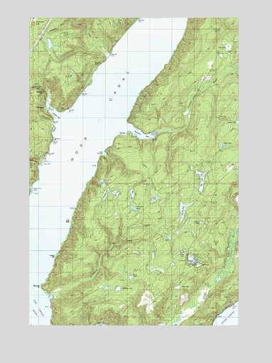
Lilliwaup, WA USGS Topographic Map
Click on map above to begin viewing in our Map Viewer.

This topographic map contains these locations and features:
Feature Name Type Latitude Longitude GNIS ID View Map
Aldrich LakeLakeN47.4326°W123.0823°1515796View Map
Cady LakeLakeN47.4262°W123.0514°1517206View Map
Cougar SpitBarN47.4081°W123.1072°1518192View Map
DewattoPopulated PlaceN47.4523°W123.0715°1518732View Map
Dewatto BayBayN47.4537°W123.0610°1518733View Map
Dewatto RiverStreamN47.4540°W123.0485°1518735View Map
Don LakeLakeN47.4280°W123.0648°1518860View Map
Dry PondLakeN47.3993°W123.0250°1518977View Map
Eagle CreekStreamN47.4851°W123.0760°1519040View Map
Grass LakeLakeN47.4046°W123.0353°1523607View Map
Jiggs LakeLakeN47.3903°W123.0374°1521365View Map
Larson LakeSwampN47.4566°W123.0008°1521914View Map
LilliwaupPopulated PlaceN47.4634°W123.1143°1522086View Map
Lilliwaup BayBayN47.4626°W123.1090°1522087View Map
Lilliwaup CreekStreamN47.4631°W123.1121°1522088View Map
Lilliwaup FallsFallsN47.4702°W123.1176°1522089View Map
Lilliwaup Post OfficePost OfficeN47.4609°W123.1141°2769189View Map
Little DewattoBayN47.4445°W123.0804°1529010View Map
Lone Duck PondLakeN47.4225°W123.0647°1522363View Map
Long PointCapeN47.4434°W123.0832°1530164View Map
Maggie LakeLakeN47.4014°W123.0291°1522635View Map
Mason County Fire District 2BuildingN47.4376°W123.0552°2643850View Map
Melbourne CreekStreamN47.4990°W123.1013°1529002View Map
Melbourne Lake DamDamN47.4981°W123.1229°1532249View Map
Miller CreekStreamN47.4304°W123.1218°1523180View Map
Musqueti PointCapeN47.3920°W123.1168°1523533View Map
North Mason Regional Fire Authority Station 28BuildingN47.4713°W123.0243°2767941View Map
North Mason Regional Fire Authority Station 82BuildingN47.4015°W123.0334°2643523View Map
North Mason Regional Fire Authority Station 83BuildingN47.3847°W123.0110°2643465View Map
Oak LakeLakeN47.4880°W123.0078°1523953View Map
Pickers PondLakeN47.4165°W123.0235°1529001View Map
Red BluffCliffN47.4173°W123.1002°1524920View Map
Rendsland CreekStreamN47.3873°W123.1113°1524999View Map
Rest - A - While MarinaLocaleN47.4397°W123.1191°2610379View Map
Rest - A - While Mobile Home ParkPopulated PlaceN47.4419°W123.1185°2607278View Map
Rest - A - While Recreational Vehicle ParkLocaleN47.4416°W123.1189°2605473View Map
Robbins LakeLakeN47.4282°W123.0807°1525091View Map
Shoe LakeLakeN47.4476°W123.0102°1525693View Map
Sund CreekStreamN47.4406°W123.1160°1526736View Map
Tahuya SchoolSchoolN47.3787°W123.0399°1526904View Map
Tee LakeLakeN47.4338°W123.0234°1526971View Map
The Peat BogSwampN47.4224°W123.0338°1529009View Map
U LakeLakeN47.4284°W123.0745°1527592View Map
Wildberry LakeSwampN47.3896°W123.0731°1528123View Map
Wood LakeLakeN47.3951°W123.0653°1528292View Map

Note: Coordinates in the location and feature list above are referenced to NAD83 datum.


Copyright (C) 2008-2024 Ryan Niemi / Sunset Dynamics ... All Rights Reserved