TopoQuest Logo
Do you find TopoQuest useful?
Help keep TopoQuest running and adding new maps/features by donating!
Bitcoin:  19c7KJd3qBynnjoSw5npx9KScwjBe4ifkT
Litecoin:  LXs6TkuXGGXo1vDsWCkWVdjQX94eUKd6ui
Home View Maps Find Maps Find Places Resources & Links


Union, Washington Topographic Map

USGS Map Title: Union, WA
USGS Map MRC: 47123C1
DRG (GeoTIFF) Download: o47123c1.tif


Neighboring USGS Topographic Map Quads:


  Hoodsport, WA  
47123D2
 

  Lilliwaup, WA  
47123D1
 

  Lake Wooten, WA  
47122D8
 

  Skokomish Valley, WA  
47123C2
 

  Union, WA  
47123C1
 

  Mason Lake, WA  
47122C8
 

  Shelton Valley, WA  
47123B2
 

  Shelton, WA  
47123B1
 

  Squaxin Island, WA  
47122B8


Map MRC Location:

N48°
W124°
N48°
W123°
H8 H7 H6 H5 H4 H3 H2 H1
G8 G7 G6 G5 G4 G3 G2 G1
F8 F7 F6 F5 F4 F3 F2 F1
E8 E7 E6 E5 E4 E3 E2 E1
D8 D7 D6 D5 D4 D3 D2 D1
C8 C7 C6 C5 C4 C3 C2 C1
B8 B7 B6 B5 B4 B3 B2 B1
A8 A7 A6 A5 A4 A3 A2 A1
N47°
W124°
N47°
W123°

Union, WA USGS 1:24K Topographic Map Preview:
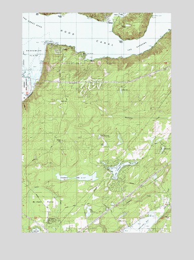
Union, WA USGS Topographic Map
Click on map above to begin viewing in our Map Viewer.

This topographic map contains these locations and features:
Feature Name Type Latitude Longitude GNIS ID View Map
AmeliaLocaleN47.3043°W123.0979°1530540View Map
Ayres PointCapeN47.3748°W123.1124°1515999View Map
Bathtub LakeLakeN47.3017°W123.0932°1516187View Map
Carson LakeLakeN47.3305°W123.0433°1517427View Map
Cranberry CreekStreamN47.2620°W123.0163°1518270View Map
Cranberry LakeLakeN47.2814°W123.0786°1518273View Map
Deepwater LakeLakeN47.3018°W123.0812°1530541View Map
Deer CreekStreamN47.2587°W123.0113°1518618View Map
Emerald LakeLakeN47.2973°W123.0087°1528993View Map
FernwoodLocaleN47.3306°W123.1165°1530127View Map
Keene LakeSwampN47.3245°W123.0947°1521590View Map
Lake LeprechaunReservoirN47.2881°W123.0529°1532082View Map
Lake LeprechaunLakeN47.2894°W123.0576°1530325View Map
Lake Leprechaun DamDamN47.2881°W123.0529°1532081View Map
Lake LimerickLakeN47.2861°W123.0455°1528992View Map
Lake Limerick DamDamN47.2815°W123.0496°1532104View Map
Lily PondLakeN47.3000°W123.0566°1528994View Map
Little Island LakeLakeN47.3046°W123.0616°1528995View Map
Malaney CreekStreamN47.2518°W123.0207°1522656View Map
Mason County Fire District 5 Station 4 - Lake LimerickBuildingN47.2750°W123.0530°2643481View Map
Mason County Fire District 5 Station 6 - Deer CreekBuildingN47.2647°W123.0019°2643519View Map
Mason County Fire District 6BuildingN47.3469°W123.0261°2643521View Map
Mason County Fire Protection District 6 Union Fire Department Station 1BuildingN47.3551°W123.0994°2619378View Map
McEwen PrairieFlatN47.2654°W123.1099°1522893View Map
New Community Church of UnionChurchN47.3465°W123.0776°2609152View Map
North Mason Regional Fire Authority Station 81BuildingN47.3726°W123.0541°2643522View Map
Pioneer Intermediate - Middle SchoolSchoolN47.2583°W123.0043°1531070View Map
Rainbow LakeLakeN47.2634°W123.0548°1530236View Map
Rex LakeLakeN47.2593°W123.0708°1525013View Map
Rosand DamDamN47.2515°W123.0996°1532587View Map
Saint Nicholas Community Episcopal ChurchChurchN47.3731°W123.0532°2609879View Map
Sisters PointCapeN47.3587°W123.0413°1525827View Map
Skokomish FlatsFlatN47.3512°W123.1213°1528973View Map
Skokomish RiverStreamN47.3401°W123.1177°1525867View Map
Skokomish ValleyValleyN47.3404°W123.1179°1525868View Map
TahuyaPopulated PlaceN47.3712°W123.0557°1526901View Map
Tahuya Post OfficePost OfficeN47.3732°W123.0529°2607031View Map
Tahuya RiverStreamN47.3704°W123.0513°1526903View Map
The Great BendBendN47.3662°W123.1193°1527035View Map
The NarrowsGutN47.3554°W123.0290°1528753View Map
UnionPopulated PlaceN47.3551°W123.1010°1527608View Map
Union Census Designated PlaceCensusN47.3475°W123.0952°2586749View Map
Union Post OfficePost OfficeN47.3464°W123.0777°2607035View Map
Webb HillRidgeN47.3190°W123.1238°1528996View Map
Wheeler LakeLakeN47.3677°W123.0377°1528021View Map

Note: Coordinates in the location and feature list above are referenced to NAD83 datum.


Copyright (C) 2008-2024 Ryan Niemi / Sunset Dynamics ... All Rights Reserved