TopoQuest Logo
Do you find TopoQuest useful?
Help keep TopoQuest running and adding new maps/features by donating!
Bitcoin:  19c7KJd3qBynnjoSw5npx9KScwjBe4ifkT
Litecoin:  LXs6TkuXGGXo1vDsWCkWVdjQX94eUKd6ui
Home View Maps Find Maps Find Places Resources & Links


Mason Lake, Washington Topographic Map

USGS Map Title: Mason Lake, WA
USGS Map MRC: 47122C8
DRG (GeoTIFF) Download: o47122c8.tif


Neighboring USGS Topographic Map Quads:


  Lilliwaup, WA  
47123D1
 

  Lake Wooten, WA  
47122D8
 

  Belfair, WA  
47122D7
 

  Union, WA  
47123C1
 

  Mason Lake, WA  
47122C8
 

  Vaughn, WA  
47122C7
 

  Shelton, WA  
47123B1
 

  Squaxin Island, WA  
47122B8
 

  Longbranch, WA  
47122B7


Map MRC Location:

N48°
W123°
N48°
W122°
H8 H7 H6 H5 H4 H3 H2 H1
G8 G7 G6 G5 G4 G3 G2 G1
F8 F7 F6 F5 F4 F3 F2 F1
E8 E7 E6 E5 E4 E3 E2 E1
D8 D7 D6 D5 D4 D3 D2 D1
C8 C7 C6 C5 C4 C3 C2 C1
B8 B7 B6 B5 B4 B3 B2 B1
A8 A7 A6 A5 A4 A3 A2 A1
N47°
W123°
N47°
W122°

Mason Lake, WA USGS 1:24K Topographic Map Preview:
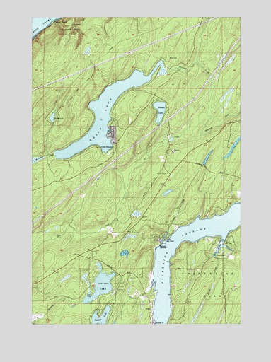
Mason Lake, WA USGS Topographic Map
Click on map above to begin viewing in our Map Viewer.

This topographic map contains these locations and features:
Feature Name Type Latitude Longitude GNIS ID View Map
AllynLocaleN47.3537°W122.8885°1511811View Map
Benson LakeLakeN47.3368°W122.9246°1503309View Map
Buck Lake DamDamN47.2515°W122.9513°1532921View Map
Courner DamDamN47.3165°W122.9246°1532588View Map
Graham PointCapeN47.2501°W122.9279°1505208View Map
GrantPopulated PlaceN47.2554°W122.9290°1511009View Map
Grapeview SchoolSchoolN47.3200°W122.9167°2605440View Map
HartstenePopulated PlaceN47.2765°W122.8871°1511026View Map
Hiawata CreekStreamN47.2837°W122.9229°1505485View Map
Hoke CreekStreamN47.2943°W122.9010°2710672View Map
Jarrell CoveBayN47.2830°W122.8875°1533045View Map
Jarrell Cove State ParkParkN47.2832°W122.8832°1531639View Map
Jarrell CreekStreamN47.2776°W122.8913°1505794View Map
Jarrell's Cove MarinaLocaleN47.2839°W122.8878°2610284View Map
Jones CreekStreamN47.2662°W122.9290°1505860View Map
Little HoquiamPopulated PlaceN47.3218°W122.9604°1512393View Map
Mason County Fire District 3 Station 2BuildingN47.2875°W122.9411°2643517View Map
Mason County Fire District 5 Station 3 Headquarters Mason - BensonBuildingN47.3433°W122.9272°2643457View Map
Mason County Fire District 5 Station 7 PickeringBuildingN47.2705°W122.9401°2643843View Map
Mason County Fire District 5 Station 9 - North Harstine IslandBuildingN47.2762°W122.8881°2643520View Map
Mason LakeLakeN47.3350°W122.9575°1506501View Map
Mason Lake LookoutLocaleN47.3470°W122.9140°1506503View Map
Phillips LakeLakeN47.2521°W122.9601°1507404View Map
Pickering PassageChannelN47.2645°W122.9232°1507407View Map
Schumacher CreekStreamN47.3187°W122.9874°1525728View Map
Shady BeachLocaleN47.3737°W122.9871°1525606View Map
South Shore Division (historical)CensusN47.2823°W122.9779°1939635View Map
Spencer LakeLakeN47.2656°W122.9601°1513213View Map
Sun PointCapeN47.2845°W122.9196°1508818View Map
Trask LakeLakeN47.3340°W122.9889°1510415View Map
Twanoh State ParkParkN47.3729°W122.9740°1527491View Map
Union-Grapeview DivisionCivilN47.3385°W122.9692°2628220View Map
Walkers LandingPopulated PlaceN47.2826°W122.9254°1511406View Map

Note: Coordinates in the location and feature list above are referenced to NAD83 datum.


Copyright (C) 2008-2024 Ryan Niemi / Sunset Dynamics ... All Rights Reserved