TopoQuest Logo
Do you find TopoQuest useful?
Help keep TopoQuest running and adding new maps/features by donating!
Bitcoin:  19c7KJd3qBynnjoSw5npx9KScwjBe4ifkT
Litecoin:  LXs6TkuXGGXo1vDsWCkWVdjQX94eUKd6ui
Home View Maps Find Maps Find Places Resources & Links


Le Sueur, Minnesota Topographic Map

USGS Map Title: Le Sueur, MN
USGS Map MRC: 44093D8
DRG (GeoTIFF) Download: o44093d8.tif


Neighboring USGS Topographic Map Quads:


  Arlington, MN  
44094E1
 

  Henderson, MN  
44093E8
 

  Belle Plaine South, MN  
44093E7
 

  Norseland, MN  
44094D1
 

  Le Sueur, MN  
44093D8
 

  Saint Thomas, MN  
44093D7
 

  North Star, MN  
44094C1
 

  Saint Peter, MN  
44093C8
 

  Cleveland, MN  
44093C7


Map MRC Location:

N45°
W94°
N45°
W93°
H8 H7 H6 H5 H4 H3 H2 H1
G8 G7 G6 G5 G4 G3 G2 G1
F8 F7 F6 F5 F4 F3 F2 F1
E8 E7 E6 E5 E4 E3 E2 E1
D8 D7 D6 D5 D4 D3 D2 D1
C8 C7 C6 C5 C4 C3 C2 C1
B8 B7 B6 B5 B4 B3 B2 B1
A8 A7 A6 A5 A4 A3 A2 A1
N44°
W94°
N44°
W93°

Le Sueur, MN USGS 1:24K Topographic Map Preview:
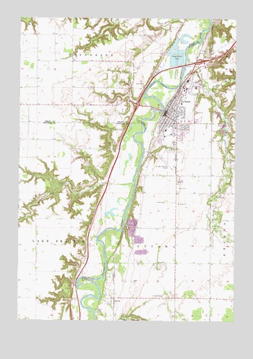
Le Sueur, MN USGS Topographic Map
Click on map above to begin viewing in our Map Viewer.

This topographic map contains these locations and features:
Feature Name Type Latitude Longitude GNIS ID View Map
Allina Medical ClinicHospitalN44.4542°W93.9150°2063498View Map
American Legion ParkParkN44.4583°W93.9078°2063513View Map
Barney Fry CreekStreamN44.4319°W93.9339°639639View Map
Calvary CemeteryCemeteryN44.4688°W93.9008°640762View Map
City of Le SueurCivilN44.4697°W93.9022°2395659View Map
Doctor William W Mayo House Historical MarkerParkN44.4617°W93.9153°2063495View Map
Evangelical Church CemeteryCemeteryN44.4061°W93.8778°2063566View Map
First Lutheran ChurchChurchN44.4550°W93.9097°2063502View Map
Forest Prairie CreekStreamN44.4711°W93.8905°643810View Map
Grace Evangelical Lutheran ChurchChurchN44.4569°W93.9100°2063499View Map
Jolly Green Giant Historical MarkerParkN44.4725°W93.9061°2063487View Map
Kingsway EstatesPopulated PlaceN44.4731°W93.8967°2063488View Map
Le SueurLocaleN44.4639°W93.9131°2063490View Map
Le SueurPopulated PlaceN44.4614°W93.9152°654787View Map
Le Sueur - Henderson High SchoolSchoolN44.4575°W93.9029°2063511View Map
Le Sueur - Henderson Middle SchoolSchoolN44.4576°W93.9016°2433079View Map
Le Sueur Country ClubLocaleN44.4269°W93.8858°659876View Map
Le Sueur CreekStreamN44.4814°W93.9039°646548View Map
Le Sueur Erosion Project DamDamN44.4700°W93.9002°1776438View Map
Le Sueur Fire DepartmentBuildingN44.4679°W93.8999°2666701View Map
Le Sueur Historical MarkerParkN44.4806°W93.8986°2063486View Map
Le Sueur Medical ClinicHospitalN44.4658°W93.9119°2063508View Map
Le Sueur Municipal AirportAirportN44.4404°W93.9130°660247View Map
Le Sueur MuseumBuildingN44.4667°W93.9086°2063590View Map
Le Sueur Police DepartmentBuildingN44.4636°W93.9142°2063492View Map
Le Sueur Post OfficePost OfficeN44.4627°W93.9147°2063491View Map
Le Sueur Public LibraryBuildingN44.4608°W93.9147°2063489View Map
Le Sueur Volunteer AmbulanceBuildingN44.4593°W93.9150°2721305View Map
Louise ParkParkN44.4619°W93.9153°2063512View Map
Mayo ParkParkN44.4808°W93.8944°2063515View Map
Mayoview History CenterBuildingN44.4617°W93.9153°2063493View Map
Minnesota River Valley Historical MarkerParkN44.4906°W93.8769°2063587View Map
Minnesota Valley Health CenterHospitalN44.4539°W93.9156°2063497View Map
Minnesota Valley Rest AreaLocaleN44.4906°W93.8769°2063589View Map
Mound CemeteryCemeteryN44.4486°W93.9102°648144View Map
OttawaPopulated PlaceN44.3822°W93.9458°649040View Map
Ottawa CemeteryCemeteryN44.3911°W93.9336°649041View Map
Ottawa Post OfficePost OfficeN44.3822°W93.9456°2063524View Map
OttowaLocaleN44.3825°W93.9447°2063523View Map
Park Elementary SchoolSchoolN44.4598°W93.9095°2063509View Map
Presbyterian ChurchChurchN44.4514°W93.9158°2063503View Map
River Hills Christian ChurchChurchN44.4642°W93.9111°2063506View Map
River ParkParkN44.4625°W93.9178°2063514View Map
Saint Anne's Catholic SchoolSchoolN44.4649°W93.9064°2063510View Map
Saint Anne's ChurchChurchN44.4619°W93.9103°2063505View Map
Saint Annes CemeteryCemeteryN44.4853°W93.8924°650503View Map
Township of OttawaCivilN44.4051°W93.9179°665238View Map
United Methodist ChurchChurchN44.4522°W93.9122°2063501View Map
Valleygreen Square MallLocaleN44.4611°W93.9153°2063496View Map
W W Mayo HouseBuildingN44.4617°W93.9153°2063494View Map
Word of Life Lutheran ChurchChurchN44.4614°W93.9150°2063504View Map
Ziebarth Alternative Learning CenterSchoolN44.4522°W93.9124°2432947View Map
Zion United Church of ChristChurchN44.4550°W93.9097°2063500View Map

Note: Coordinates in the location and feature list above are referenced to NAD83 datum.


Copyright (C) 2008-2024 Ryan Niemi / Sunset Dynamics ... All Rights Reserved