TopoQuest Logo
Do you find TopoQuest useful?
Help keep TopoQuest running and adding new maps/features by donating!
Bitcoin:  19c7KJd3qBynnjoSw5npx9KScwjBe4ifkT
Litecoin:  LXs6TkuXGGXo1vDsWCkWVdjQX94eUKd6ui
Home View Maps Find Maps Find Places Resources & Links


Kamas, Utah Topographic Map

USGS Map Title: Kamas, UT
USGS Map MRC: 40111F3
DRG (GeoTIFF) Download: o40111f3.tif


Neighboring USGS Topographic Map Quads:


  Wanship, UT  
40111G4
 

  Crandall Canyon, UT  
40111G3
 

  Hidden Lake, UT  
40111G2
 

  Park City East, UT  
40111F4
 

  Kamas, UT  
40111F3
 

  Hoyt Peak, UT  
40111F2
 

  Heber City, UT  
40111E4
 

  Francis, UT  
40111E3
 

  Woodland, UT  
40111E2


Map MRC Location:

N41°
W112°
N41°
W111°
H8 H7 H6 H5 H4 H3 H2 H1
G8 G7 G6 G5 G4 G3 G2 G1
F8 F7 F6 F5 F4 F3 F2 F1
E8 E7 E6 E5 E4 E3 E2 E1
D8 D7 D6 D5 D4 D3 D2 D1
C8 C7 C6 C5 C4 C3 C2 C1
B8 B7 B6 B5 B4 B3 B2 B1
A8 A7 A6 A5 A4 A3 A2 A1
N40°
W112°
N40°
W111°

Kamas, UT USGS 1:24K Topographic Map Preview:
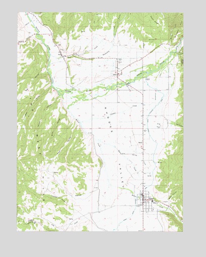
Kamas, UT USGS Topographic Map
Click on map above to begin viewing in our Map Viewer.

This topographic map contains these locations and features:
Feature Name Type Latitude Longitude GNIS ID View Map
Baptist Community Bible ChurchChurchN40.6480°W111.2827°1449223View Map
Beaver CreekStreamN40.7025°W111.3421°1438526View Map
Big HollowValleyN40.7155°W111.3530°1438687View Map
Boulderville DitchCanalN40.7088°W111.2702°1439029View Map
Browns CanyonValleyN40.7369°W111.3641°1439172View Map
City CreekStreamN40.6547°W111.3074°1439753View Map
City of KamasCivilN40.6499°W111.2722°2410162View Map
City of OakleyCivilN40.7259°W111.2770°2411296View Map
Crooked CreekStreamN40.6872°W111.3285°1440167View Map
Elder HollowValleyN40.6408°W111.2646°1440885View Map
Fort CreekStreamN40.7258°W111.3510°1441185View Map
Hoyt CanyonValleyN40.6869°W111.2624°1441932View Map
Indian HollowValleyN40.6497°W111.3149°1442011View Map
Jensen HollowValleyN40.7022°W111.3441°1442124View Map
KamasPopulated PlaceN40.6430°W111.2807°1442266View Map
Kamas Bible Church CemeteryCemeteryN40.6480°W111.2824°2769283View Map
Kamas Police DepartmentBuildingN40.6457°W111.2803°2730456View Map
Kamas Post OfficePost OfficeN40.6443°W111.2820°1455349View Map
Kamas ValleyValleyN40.7277°W111.3477°1455903View Map
Log HollowValleyN40.7372°W111.3038°1442848View Map
Maple RidgeRidgeN40.7486°W111.2771°1443176View Map
MarionPopulated PlaceN40.6775°W111.2810°1443196View Map
Marion CemeteryCemeteryN40.6844°W111.2677°1443197View Map
Marion Census Designated PlaceCensusN40.6813°W111.2829°2584771View Map
Miles HollowValleyN40.6922°W111.3369°1443388View Map
Neel HollowValleyN40.7074°W111.3505°1443781View Map
North Bench CemeteryCemeteryN40.7244°W111.2994°2769281View Map
OakleyPopulated PlaceN40.7147°W111.3007°1444043View Map
Oakley CemeteryCemeteryN40.7234°W111.2998°1444044View Map
Oakley Post OfficePost OfficeN40.7146°W111.3000°2767354View Map
PeoaPopulated PlaceN40.7247°W111.3419°1444282View Map
Peoa CemeteryCemeteryN40.7311°W111.3457°1444283View Map
Peoa Census Designated PlaceCensusN40.7256°W111.3380°2584774View Map
Pinon CanyonValleyN40.7269°W111.2557°1444426View Map
Rasmussen CreekStreamN40.7249°W111.3305°1444725View Map
Rock HollowValleyN40.6863°W111.3302°1445074View Map
Seymour CanyonValleyN40.7177°W111.2569°1445455View Map
South Summit Emergency Medical Service AmbulanceBuildingN40.6363°W111.2762°2665444View Map
South Summit Fire DistrictBuildingN40.7169°W111.3007°2627258View Map
South Summit Fire District - KamasBuildingN40.6428°W111.2810°2627415View Map
South Summit High SchoolSchoolN40.6420°W111.2736°1445925View Map
Spring CreekStreamN40.6688°W111.2969°1446004View Map
Stevens CemeteryCemeteryN40.7219°W111.3000°1446139View Map
The Church of Jesus Christ of Latter Day SaintsChurchN40.7255°W111.3430°1449587View Map
The Church of Jesus Christ of Latter Day SaintsChurchN40.6869°W111.2805°1455658View Map
The Church of Jesus Christ of Latter Day SaintsChurchN40.6433°W111.2824°1449496View Map
The West HillsRangeN40.6766°W111.3574°1446516View Map
Thorn CreekStreamN40.6769°W111.3144°1446549View Map
United States Forest Service Kamas Ranger DistrictBuildingN40.6429°W111.2796°2627249View Map
Weber Provo Diversion CanalCanalN40.6730°W111.2710°1447093View Map
Whites CreekStreamN40.7272°W111.2607°1447293View Map

Note: Coordinates in the location and feature list above are referenced to NAD83 datum.


Copyright (C) 2008-2024 Ryan Niemi / Sunset Dynamics ... All Rights Reserved