TopoQuest Logo
Do you find TopoQuest useful?
Help keep TopoQuest running and adding new maps/features by donating!
Bitcoin:  19c7KJd3qBynnjoSw5npx9KScwjBe4ifkT
Litecoin:  LXs6TkuXGGXo1vDsWCkWVdjQX94eUKd6ui
Home View Maps Find Maps Find Places Resources & Links


Park City East, Utah Topographic Map

USGS Map Title: Park City East, UT
USGS Map MRC: 40111F4
DRG (GeoTIFF) Download: o40111f4.tif


Neighboring USGS Topographic Map Quads:


  Big Dutch Hollow, UT  
40111G5
 

  Wanship, UT  
40111G4
 

  Crandall Canyon, UT  
40111G3
 

  Park City West, UT  
40111F5
 

  Park City East, UT  
40111F4
 

  Kamas, UT  
40111F3
 

  Brighton, UT  
40111E5
 

  Heber City, UT  
40111E4
 

  Francis, UT  
40111E3


Map MRC Location:

N41°
W112°
N41°
W111°
H8 H7 H6 H5 H4 H3 H2 H1
G8 G7 G6 G5 G4 G3 G2 G1
F8 F7 F6 F5 F4 F3 F2 F1
E8 E7 E6 E5 E4 E3 E2 E1
D8 D7 D6 D5 D4 D3 D2 D1
C8 C7 C6 C5 C4 C3 C2 C1
B8 B7 B6 B5 B4 B3 B2 B1
A8 A7 A6 A5 A4 A3 A2 A1
N40°
W112°
N40°
W111°

Park City East, UT USGS 1:24K Topographic Map Preview:
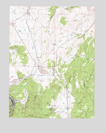
Park City East, UT USGS Topographic Map
Click on map above to begin viewing in our Map Viewer.

This topographic map contains these locations and features:
Feature Name Type Latitude Longitude GNIS ID View Map
Armstrong SpringSpringN40.7080°W111.4330°1425171View Map
AtkinsonPopulated PlaceN40.7405°W111.4749°1437491View Map
Clark RanchLocaleN40.6666°W111.4549°1426662View Map
Constellation ShaftMineN40.6344°W111.4860°1426830View Map
Curley Sage FlatFlatN40.6947°W111.3927°1427159View Map
Deer ValleyValleyN40.6475°W111.4769°1427324View Map
Deer Valley MeadowFlatN40.6441°W111.4788°1427325View Map
Deer Valley ResortLocaleN40.6313°W111.4794°1435399View Map
Dority SpringSpringN40.6708°W111.4974°1427453View Map
Drain Tunnel Number 1CanalN40.6336°W111.4932°1454424View Map
East OntarioMineN40.6361°W111.4638°1427714View Map
East Utah ShaftMineN40.6283°W111.4438°1427733View Map
Empire CanyonValleyN40.6355°W111.4963°1440935View Map
Frog ValleyValleyN40.6422°W111.4780°1428105View Map
Health South Surgery Center of Park CityHospitalN40.6638°W111.4977°2432254View Map
HideoutPopulated PlaceN40.6380°W111.4108°2519169View Map
Hogs BackRidgeN40.7205°W111.3905°1428756View Map
Homer SpringSpringN40.6923°W111.4591°1428791View Map
Jordanelle Fire StationBuildingN40.6391°W111.4482°1901349View Map
KeetleyPopulated PlaceN40.6355°W111.4146°1437600View Map
Keetley JunctionPopulated PlaceN40.6825°W111.4577°1437601View Map
Keetley StationLocaleN40.6358°W111.4374°1429295View Map
KPCW-FM (Park City)TowerN40.6436°W111.4963°1455801View Map
Marsac School (historical)SchoolN40.6441°W111.4946°1430113View Map
Masonic HillSummitN40.6547°W111.4952°1430135View Map
McCune HollowValleyN40.6327°W111.4202°1430169View Map
McCune TunnelMineN40.6283°W111.4455°1430171View Map
McPolin Elementary SchoolSchoolN40.6696°W111.4930°1901348View Map
Mountain MeadowsFlatN40.7063°W111.4307°1430531View Map
Mud SpringsSpringN40.6911°W111.3838°1430583View Map
National Ability CenterSchoolN40.6805°W111.4755°1901347View Map
Ontario CanyonValleyN40.6458°W111.4966°1431009View Map
Ontario Drain TunnelTunnelN40.6294°W111.4613°1431010View Map
Ontario RidgeRidgeN40.6327°W111.4960°1431011View Map
Park CityPopulated PlaceN40.6461°W111.4980°1444206View Map
Park City City HallBuildingN40.6441°W111.4946°1901344View Map
Park City ConsolidatedMineN40.6375°W111.4766°1431104View Map
Park City Fire District Station 37BuildingN40.7233°W111.4709°2627209View Map
Park City Fire District Station 38BuildingN40.6457°W111.4784°2627411View Map
Park City High SchoolSchoolN40.6670°W111.4972°1436099View Map
Park City Medical CenterHospitalN40.6877°W111.4694°2722358View Map
Park City Post Office Old Town StationPost OfficeN40.6441°W111.4958°1455448View Map
Park KingMineN40.6252°W111.4571°1431106View Map
Park KonoldMineN40.6252°W111.3913°1431107View Map
Queen Esther ShaftMineN40.6480°W111.4732°1431524View Map
Richardson FlatFlatN40.6711°W111.4496°1431776View Map
Ross CreekStreamN40.6344°W111.4185°1432010View Map
Rossi HillSummitN40.6422°W111.4913°1432011View Map
Round ValleyValleyN40.7013°W111.4908°1432027View Map
Sage Hen HollowValleyN40.6405°W111.4230°1432095View Map
Saint Lukes Episcopal ChurchChurchN40.6441°W111.4971°1450640View Map
Saint Marys Catholic ChurchChurchN40.6400°W111.4949°1450643View Map
Silver Creek JunctionPopulated PlaceN40.7313°W111.4980°1445593View Map
Silver Creek Wastewater Treatment PlantBuildingN40.7338°W111.4802°1901345View Map
Silver King ExtensionMineN40.6680°W111.4788°1432462View Map
Silver Summit Census Designated PlaceCensusN40.7434°W111.4905°2584775View Map
Snow Park Ski LiftsLocaleN40.6325°W111.4819°1454524View Map
Snow ShedBuildingN40.6380°W111.4999°1432598View Map
Summit County JailBuildingN40.7204°W111.4782°2730323View Map
Summit County Justice CenterBuildingN40.7205°W111.4783°1901346View Map
Summit County Sheriff's OfficeBuildingN40.7205°W111.4784°2730373View Map
Todd HollowValleyN40.6833°W111.3991°1433559View Map
Town of HideoutCivilN40.6429°W111.4006°2519168View Map
Treasure Mountain Junior High SchoolSchoolN40.6695°W111.4904°1436520View Map
United Methodist Christian Science Society Park City Community ChurchChurchN40.6458°W111.4960°1450627View Map
Utah Highway Patrol Section 7 Heber OfficeBuildingN40.6336°W111.4470°2730471View Map
Wasatch County Fire District JordanelleBuildingN40.6335°W111.4472°2627353View Map
Woodside GulchValleyN40.6397°W111.4960°1447525View Map

Note: Coordinates in the location and feature list above are referenced to NAD83 datum.


Copyright (C) 2008-2024 Ryan Niemi / Sunset Dynamics ... All Rights Reserved