TopoQuest Logo
Do you find TopoQuest useful?
Help keep TopoQuest running and adding new maps/features by donating!
Bitcoin:  19c7KJd3qBynnjoSw5npx9KScwjBe4ifkT
Litecoin:  LXs6TkuXGGXo1vDsWCkWVdjQX94eUKd6ui
Home View Maps Find Maps Find Places Resources & Links


Illinois City, Illinois Topographic Map

USGS Map Title: Illinois City, IL
USGS Map MRC: 41090D8
DRG (GeoTIFF) Download: o41090d8.tif


Neighboring USGS Topographic Map Quads:


  Wilton, IA  
41091E1
 

  Durant, IA  
41090E8
 

  Walcott, IA  
41090E7
 

  Muscatine, IA  
41091D1
 

  Illinois City, IL  
41090D8
 

  Montpelier, IA  
41090D7
 

  Blanchard Island, IL  
41091C1
 

  Eliza, IL  
41090C8
 

  Buffalo Prairie, IL  
41090C7


Map MRC Location:

N42°
W91°
N42°
W90°
H8 H7 H6 H5 H4 H3 H2 H1
G8 G7 G6 G5 G4 G3 G2 G1
F8 F7 F6 F5 F4 F3 F2 F1
E8 E7 E6 E5 E4 E3 E2 E1
D8 D7 D6 D5 D4 D3 D2 D1
C8 C7 C6 C5 C4 C3 C2 C1
B8 B7 B6 B5 B4 B3 B2 B1
A8 A7 A6 A5 A4 A3 A2 A1
N41°
W91°
N41°
W90°

Illinois City, IL USGS 1:24K Topographic Map Preview:
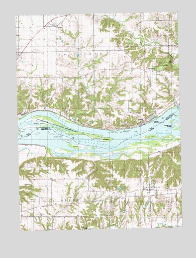
Illinois City, IL USGS Topographic Map
Click on map above to begin viewing in our Map Viewer.

This topographic map contains these locations and features:
Feature Name Type Latitude Longitude GNIS ID View Map
Andalusia SloughStreamN41.4309°W90.8918°403499View Map
Dead SloughLakeN41.4176°W90.9264°2747112View Map
Donnelly PondReservoirN41.3954°W90.9409°1691651View Map
Donnelly Pond DamDamN41.3950°W90.9435°1691650View Map
Drury SloughStreamN41.4234°W90.9621°407407View Map
FairportLocaleN41.4359°W90.9046°2000471View Map
FairportPopulated PlaceN41.4359°W90.9046°456474View Map
Fairport CemeteryCemeteryN41.4417°W90.9054°456475View Map
Fairport Post Office (historical)Post OfficeN41.4359°W90.9046°2000470View Map
Fairport Recreation AreaParkN41.4323°W90.9251°2000540View Map
Fairport State Fish HatcheryLocaleN41.4389°W90.8974°2000541View Map
Geneva IslandIslandN41.4350°W90.9663°456869View Map
Geneva Post Office (historical)Post OfficeN41.4459°W90.9793°2000450View Map
Geneva SchoolSchoolN41.4439°W90.9946°456870View Map
Goose IslandIslandN41.4314°W90.9193°456969View Map
Harker CemeteryCemeteryN41.4791°W90.9599°457258View Map
Hershey Chute Post LightBuildingN41.4312°W90.9101°2680975View Map
Hershey IslandIslandN41.4273°W90.9638°410111View Map
Hershey SloughStreamN41.4303°W90.9968°457404View Map
Highland SchoolSchoolN41.4589°W90.9590°457483View Map
Illinois CityPopulated PlaceN41.3975°W90.8996°410764View Map
Illinois City CemeteryCemeteryN41.4014°W90.8974°1967509View Map
Illinois City Community Fire Protection DistrictBuildingN41.3977°W90.9007°2640649View Map
Illinois City Elementary SchoolSchoolN41.3989°W90.9018°2042121View Map
Illinois City Post OfficePost OfficeN41.3970°W90.9006°2788623View Map
Illinois City United Methodist ChurchChurchN41.3959°W90.8993°2042562View Map
Island Number 328IslandN41.4284°W90.8954°425048View Map
Island Number 330IslandN41.4231°W90.9529°425049View Map
Jimtown School (historical)SchoolN41.4173°W90.9804°411119View Map
Krell CemeteryCemeteryN41.4663°W90.9326°458145View Map
Martin IslandIslandN41.4274°W90.8836°2747110View Map
McLaughlin PondReservoirN41.3984°W90.9223°1691965View Map
McLaughlin Pond DamDamN41.4000°W90.9235°1691964View Map
New EraPopulated PlaceN41.4661°W90.8921°464666View Map
New Era Ziegler Memorial ChurchChurchN41.4664°W90.8940°459472View Map
Pine Bluff ChurchChurchN41.4045°W90.9749°415693View Map
Pine Bluff SchoolSchoolN41.4681°W90.9115°460158View Map
Pine Bluff School (historical)SchoolN41.4045°W90.9849°415695View Map
Providence ChurchChurchN41.3836°W90.9846°416258View Map
Reynolds School (historical)SchoolN41.3834°W90.9888°416571View Map
Scisco ChuteGutN41.4262°W90.8986°2747111View Map
Sweetland (historical)LocaleN41.4934°W90.9685°2000468View Map
Sweetland CenterPopulated PlaceN41.4934°W90.9696°464769View Map
Sweetland Centre Post Office (historical)Post OfficeN41.4931°W90.9707°466618View Map
Sweetland CreekStreamN41.4370°W90.9568°462151View Map
Sweetland Post Office (historical)Post OfficeN41.4934°W90.9685°2000469View Map
Sweetland United Methodist ChurchChurchN41.4925°W90.9685°2000534View Map
Thudwhomp Airport (historical)AirportN41.4003°W90.9907°427392View Map
Township of DruryCivilN41.3779°W90.9784°428912View Map
Township of SweetlandCivilN41.4733°W90.9562°468774View Map
Union SchoolSchoolN41.4750°W90.9993°462469View Map
White Oak School (historical)SchoolN41.3973°W90.9282°421060View Map
Wildcat Den State ParkParkN41.4678°W90.8813°463037View Map
Wyoming SloughStreamN41.4400°W90.9940°463227View Map
Ziegler Memorial Lutheran ChurchChurchN41.4664°W90.8938°2000539View Map

Note: Coordinates in the location and feature list above are referenced to NAD83 datum.


Copyright (C) 2008-2024 Ryan Niemi / Sunset Dynamics ... All Rights Reserved