TopoQuest Logo
Do you find TopoQuest useful?
Help keep TopoQuest running and adding new maps/features by donating!
Bitcoin:  19c7KJd3qBynnjoSw5npx9KScwjBe4ifkT
Litecoin:  LXs6TkuXGGXo1vDsWCkWVdjQX94eUKd6ui
Home View Maps Find Maps Find Places Resources & Links


Hutchinson East, Minnesota Topographic Map

USGS Map Title: Hutchinson East, MN
USGS Map MRC: 44094H3
DRG (GeoTIFF) Download: o44094h3.tif


Neighboring USGS Topographic Map Quads:


  Darwin, MN  
45094A4
 

  Dassel, MN  
45094A3
 

  Cokato, MN  
45094A2
 

  Hutchinson West, MN  
44094H4
 

  Hutchinson East, MN  
44094H3
 

  Silver Lake, MN  
44094H2
 

  Heatwole, MN  
44094G4
 

  Biscay, MN  
44094G3
 

  Glencoe, MN  
44094G2


Map MRC Location:

N45°
W95°
N45°
W94°
H8 H7 H6 H5 H4 H3 H2 H1
G8 G7 G6 G5 G4 G3 G2 G1
F8 F7 F6 F5 F4 F3 F2 F1
E8 E7 E6 E5 E4 E3 E2 E1
D8 D7 D6 D5 D4 D3 D2 D1
C8 C7 C6 C5 C4 C3 C2 C1
B8 B7 B6 B5 B4 B3 B2 B1
A8 A7 A6 A5 A4 A3 A2 A1
N44°
W95°
N44°
W94°

Hutchinson East, MN USGS 1:24K Topographic Map Preview:
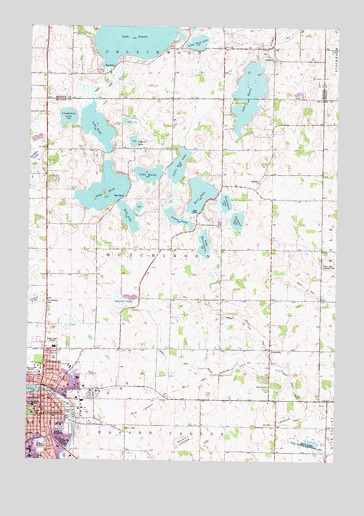
Hutchinson East, MN USGS Topographic Map
Click on map above to begin viewing in our Map Viewer.

This topographic map contains these locations and features:
Feature Name Type Latitude Longitude GNIS ID View Map
Apostolic Lighthouse ChurchChurchN44.8861°W94.3650°2065311View Map
Austin SchoolSchoolN44.9302°W94.3469°639534View Map
Bear LakeLakeN44.9519°W94.3057°639766View Map
Bear Lake SchoolSchoolN44.9558°W94.2819°639780View Map
Belden LakeSwampN44.9619°W94.3736°639877View Map
Benjamin LakebedFlatN44.8805°W94.3114°1815312View Map
Boy Scout ParkParkN44.8950°W94.3619°2065348View Map
Calvary Wesleyan ChurchChurchN44.8986°W94.3722°2065309View Map
Cedar Hill OrchardLocaleN44.9564°W94.2842°2647720View Map
Cloverdale SchoolSchoolN44.8991°W94.3230°641356View Map
Congergational United Church of ChristChurchN44.8881°W94.3689°2065305View Map
County Ditch Number SixteenCanalN44.8958°W94.2664°1815316View Map
County Ditch Number Sixteen ACanalN44.9022°W94.3080°1815315View Map
Crow River Recreational AreaParkN44.8956°W94.3661°2065341View Map
Echo LakeLakeN44.9454°W94.3350°643150View Map
Eheim ParkParkN44.8961°W94.3692°2065342View Map
Faith Lutheran ChurchChurchN44.8878°W94.3683°2065296View Map
Fireman's ParkParkN44.8950°W94.3686°2065344View Map
Girl Scout ParkParkN44.8953°W94.3692°2065343View Map
Grace Lutheran ChurchChurchN44.8864°W94.3747°2065307View Map
Halva Marsh State Wildlife Management AreaParkN44.8800°W94.2600°1815314View Map
HutchinsonPopulated PlaceN44.8877°W94.3697°645316View Map
HutchinsonLocaleN44.8953°W94.3653°2065281View Map
Hutchinson City HallBuildingN44.8908°W94.3675°2065314View Map
Hutchinson City LibraryBuildingN44.8919°W94.3678°2065315View Map
Hutchinson Community HospitalHospitalN44.8758°W94.3733°2065327View Map
Hutchinson DamDamN44.8950°W94.3686°1776161View Map
Hutchinson Fire DepartmentBuildingN44.8892°W94.3660°2065316View Map
Hutchinson Foot ClinicHospitalN44.8908°W94.3681°2065324View Map
Hutchinson Health ClinicHospitalN44.8753°W94.3721°2065325View Map
Hutchinson Health HospitalHospitalN44.8759°W94.3734°2065326View Map
Hutchinson Park Elementary SchoolSchoolN44.8907°W94.3727°2065338View Map
Hutchinson Police DepartmentBuildingN44.8917°W94.3710°2065318View Map
Hutchinson Post OfficePost OfficeN44.8892°W94.3689°2066842View Map
Hutchinson Post OfficePost OfficeN44.8891°W94.3690°2066205View Map
Hutchinson Stockade Historical MarkerParkN44.8908°W94.3667°2065383View Map
J W FieldAirportN44.9474°W94.2611°2770419View Map
Jehovah's WitnessesChurchN44.8975°W94.3722°2065308View Map
Judicial Ditch Number NineCanalN44.9161°W94.2897°1815317View Map
Judicial Ditch Number ThirteenCanalN44.9822°W94.3436°1815321View Map
KDUZ-AM (Hutchinson)TowerN44.9066°W94.3667°663213View Map
Kimberly ParkParkN44.8925°W94.3472°2065346View Map
KKJR-FM (Hutchinson)TowerN44.9066°W94.3667°663296View Map
KomenskyPopulated PlaceN44.9072°W94.2769°654780View Map
Lake ByronLakeN44.9808°W94.2865°640722View Map
Lake EmilyLakeN44.9576°W94.3265°643342View Map
Lake HarringtonLakeN44.9375°W94.3037°644684View Map
Lake HookLakeN44.9530°W94.3444°645157View Map
Lake Hook SchoolSchoolN44.9644°W94.3475°646363View Map
Lake JennieLakeN44.9995°W94.3332°645623View Map
Lake ToddLakeN44.9709°W94.3478°653222View Map
LamsonPopulated PlaceN44.9902°W94.2747°654783View Map
Lamson Post Office (historical)Post OfficeN44.9903°W94.2744°2065961View Map
Lamson Post Office (historical)Post OfficeN44.9903°W94.2744°2066598View Map
Lamson SchoolSchoolN44.9980°W94.2972°646462View Map
Legion ParkParkN44.8811°W94.3689°2065353View Map
Lions Park EastParkN44.8956°W94.3606°2065347View Map
Little Bear LakeLakeN44.9598°W94.3147°646758View Map
Little Wolf LakeLakeN44.9955°W94.3074°646968View Map
Loughman LakeLakeN44.9738°W94.3597°1815320View Map
Maplewood AcademySchoolN44.9012°W94.3696°647504View Map
McLeod County Veterans Memorial ParkParkN44.8944°W94.3639°2065345View Map
Mud LakebedFlatN44.8889°W94.3280°1815311View Map
Mud LakebedFlatN44.8861°W94.2725°1815313View Map
New Century AcademySchoolN44.8863°W94.3526°2065330View Map
North ParkParkN44.8916°W94.3683°1815308View Map
North Woods ParkParkN44.9044°W94.3639°2065340View Map
Northwoods Elementary SchoolSchoolN44.9027°W94.3730°2065329View Map
O'Mera LakeLakeN44.9667°W94.3333°1815319View Map
Oak Heights Covenant ChurchChurchN44.8906°W94.3694°2065295View Map
Oakland CemeteryCemeteryN44.8791°W94.3696°1815305View Map
Old Bass Pond ParkParkN44.8922°W94.3583°2065351View Map
Otter LakeReservoirN44.8950°W94.3686°1776162View Map
Our Savior's Lutheran ChurchChurchN44.9017°W94.3572°2065299View Map
Our Saviors SchoolSchoolN44.9016°W94.3578°1815310View Map
Peace Lutheran ChurchChurchN44.8875°W94.3711°2065306View Map
Piker LakeLakeN44.9450°W94.3161°1815318View Map
Saint Anastasia CemeteryCemeteryN44.9205°W94.3682°650492View Map
Sarr ParkParkN44.8983°W94.3703°1815309View Map
Seventh Day Adventist ChurchChurchN44.9022°W94.3689°2065294View Map
Silver Lake Landing Field (historical)AirportN44.9305°W94.2511°1815304View Map
South ParkParkN44.8889°W94.3733°1815307View Map
Sustacek LakeLakeN44.9442°W94.2907°652864View Map
Tartan ParkParkN44.8889°W94.3583°1815306View Map
Tomlinson LakeLakeN44.9494°W94.2954°653228View Map
Township of HutchinsonCivilN44.9377°W94.3154°664537View Map
VFW ParkParkN44.8778°W94.3669°2065352View Map
Walker LakeSwampN44.9208°W94.3364°653734View Map

Note: Coordinates in the location and feature list above are referenced to NAD83 datum.


Copyright (C) 2008-2024 Ryan Niemi / Sunset Dynamics ... All Rights Reserved