TopoQuest Logo
Do you find TopoQuest useful?
Help keep TopoQuest running and adding new maps/features by donating!
Bitcoin:  19c7KJd3qBynnjoSw5npx9KScwjBe4ifkT
Litecoin:  LXs6TkuXGGXo1vDsWCkWVdjQX94eUKd6ui
Home View Maps Find Maps Find Places Resources & Links


Henry, South Carolina Topographic Map

USGS Map Title: Henry, SC
USGS Map MRC: 33079F4
DRG (GeoTIFF) Download: o33079f4.tif


Neighboring USGS Topographic Map Quads:


  Prospect Crossroads, SC  
33079G5
 

  Johnsonville, SC  
33079G4
 

  Snow Island, SC  
33079G3
 

  Indiantown, SC  
33079F5
 

  Henry, SC  
33079F4
 

  Outland, SC  
33079F3
 

  Warsaw, SC  
33079E5
 

  Rhems, SC  
33079E4
 

  Carvers Bay, SC  
33079E3


Map MRC Location:

N34°
W80°
N34°
W79°
H8 H7 H6 H5 H4 H3 H2 H1
G8 G7 G6 G5 G4 G3 G2 G1
F8 F7 F6 F5 F4 F3 F2 F1
E8 E7 E6 E5 E4 E3 E2 E1
D8 D7 D6 D5 D4 D3 D2 D1
C8 C7 C6 C5 C4 C3 C2 C1
B8 B7 B6 B5 B4 B3 B2 B1
A8 A7 A6 A5 A4 A3 A2 A1
N33°
W80°
N33°
W79°

Henry, SC USGS 1:24K Topographic Map Preview:
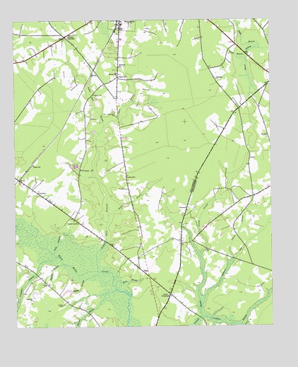
Henry, SC USGS Topographic Map
Click on map above to begin viewing in our Map Viewer.

This topographic map contains these locations and features:
Feature Name Type Latitude Longitude GNIS ID View Map
BarnhillPopulated PlaceN33.7024°W79.3756°1231029View Map
Bethel SchoolSchoolN33.6910°W79.4906°1246806View Map
Brockington PondReservoirN33.6401°W79.4746°1239703View Map
Brockington Pond Dam D-3100DamN33.6402°W79.4731°1239702View Map
Brunson CrossroadsPopulated PlaceN33.7435°W79.4745°1247032View Map
Burnett SwampStreamN33.6402°W79.4503°1247067View Map
Campbell SwampStreamN33.6535°W79.4781°1247130View Map
Caney BranchStreamN33.7068°W79.4559°1221318View Map
Cedar BranchStreamN33.7382°W79.3795°1221425View Map
ChandlersPopulated PlaceN33.6802°W79.4887°1231154View Map
Chavis ChurchChurchN33.7274°W79.4498°1241401View Map
Chavis Elementary SchoolSchoolN33.7286°W79.4498°2486512View Map
Chavis School (historical)SchoolN33.7118°W79.4503°1241402View Map
Church BranchStreamN33.6527°W79.3931°1221590View Map
CookPopulated PlaceN33.6424°W79.4842°1227885View Map
Cook Fire TowerTowerN33.6338°W79.4773°1241403View Map
GordonvillePopulated PlaceN33.6868°W79.4453°1245788View Map
Harmon CemeteryCemeteryN33.7196°W79.4609°1223041View Map
Headless CreekStreamN33.6657°W79.4998°1245932View Map
Hemingway DivisionCivilN33.7310°W79.4382°1938295View Map
Hemingway High SchoolSchoolN33.7480°W79.4468°2486510View Map
HenryPopulated PlaceN33.6854°W79.4976°1231374View Map
Henry ChurchChurchN33.6913°W79.4906°1241426View Map
HopewellPopulated PlaceN33.6741°W79.4159°1227919View Map
Hopewell ChurchChurchN33.6702°W79.4170°1232356View Map
Hopewell School (historical)SchoolN33.6724°W79.4162°1232357View Map
Hughs BranchStreamN33.6707°W79.4542°1223387View Map
Island BranchStreamN33.7357°W79.3870°1223465View Map
Johnson BranchStreamN33.6510°W79.4764°1223600View Map
Johnson HospitalHospitalN33.7499°W79.4478°1247894View Map
Manbess ChurchChurchN33.7285°W79.4612°1224287View Map
Matthews ChurchChurchN33.7313°W79.4481°1224368View Map
OwensPopulated PlaceN33.6935°W79.3851°1227955View Map
Pentecostal ChurchChurchN33.6660°W79.4062°1232428View Map
Pittman BranchStreamN33.6291°W79.4098°1250148View Map
Poplar HillPopulated PlaceN33.7268°W79.4492°1231678View Map
Poplar Hill BranchStreamN33.6479°W79.4595°1250213View Map
Poplar Hill CemeteryCemeteryN33.7107°W79.4495°1241490View Map
Poplar Hill ChurchChurchN33.7116°W79.4503°1250215View Map
RomePopulated PlaceN33.6479°W79.4384°1250461View Map
Rome BranchStreamN33.6402°W79.4503°1226003View Map
Sand Hill ChurchChurchN33.6363°W79.4917°1226326View Map
Shavers SchoolSchoolN33.7277°W79.4495°1250852View Map
Snow BranchStreamN33.6549°W79.4812°1226726View Map
Snow JunctionPopulated PlaceN33.6691°W79.4714°1227982View Map
Squirrel RunStreamN33.6335°W79.4092°1251022View Map
Thompson ChurchChurchN33.7263°W79.4009°1227104View Map
Union CemeteryCemeteryN33.6382°W79.4239°1232487View Map
Union ChurchChurchN33.6377°W79.4242°1232488View Map
Union CrossroadsPopulated PlaceN33.6382°W79.4245°1251263View Map
Union Public School (historical)SchoolN33.6354°W79.4253°1232489View Map
Union School (historical)SchoolN33.6374°W79.4237°1232490View Map
Walden BranchStreamN33.6479°W79.4581°1227371View Map
Waterman BranchStreamN33.6885°W79.4609°1227429View Map
WKYB-AM (Hemingway)TowerN33.6988°W79.4587°1252369View Map

Note: Coordinates in the location and feature list above are referenced to NAD83 datum.


Copyright (C) 2008-2024 Ryan Niemi / Sunset Dynamics ... All Rights Reserved