TopoQuest Logo
Do you find TopoQuest useful?
Help keep TopoQuest running and adding new maps/features by donating!
Bitcoin:  19c7KJd3qBynnjoSw5npx9KScwjBe4ifkT
Litecoin:  LXs6TkuXGGXo1vDsWCkWVdjQX94eUKd6ui
Home View Maps Find Maps Find Places Resources & Links


Carvers Bay, South Carolina Topographic Map

USGS Map Title: Carvers Bay, SC
USGS Map MRC: 33079E3
DRG (GeoTIFF) Download: o33079e3.tif


Neighboring USGS Topographic Map Quads:


  Henry, SC  
33079F4
 

  Outland, SC  
33079F3
 

  Yauhannah, SC  
33079F2
 

  Rhems, SC  
33079E4
 

  Carvers Bay, SC  
33079E3
 

  Plantersville, SC  
33079E2
 

  Olin, SC  
33079D4
 

  Georgetown North, SC  
33079D3
 

  Waverly Mills, SC  
33079D2


Map MRC Location:

N34°
W80°
N34°
W79°
H8 H7 H6 H5 H4 H3 H2 H1
G8 G7 G6 G5 G4 G3 G2 G1
F8 F7 F6 F5 F4 F3 F2 F1
E8 E7 E6 E5 E4 E3 E2 E1
D8 D7 D6 D5 D4 D3 D2 D1
C8 C7 C6 C5 C4 C3 C2 C1
B8 B7 B6 B5 B4 B3 B2 B1
A8 A7 A6 A5 A4 A3 A2 A1
N33°
W80°
N33°
W79°

Carvers Bay, SC USGS 1:24K Topographic Map Preview:
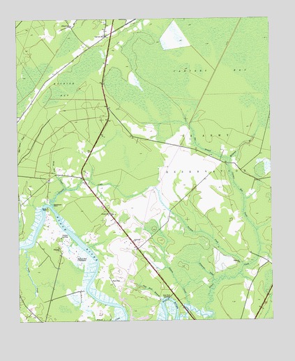
Carvers Bay, SC USGS Topographic Map
Click on map above to begin viewing in our Map Viewer.

This topographic map contains these locations and features:
Feature Name Type Latitude Longitude GNIS ID View Map
Annie Village ChurchChurchN33.5446°W79.3289°1232246View Map
Annie Village School (historical)SchoolN33.5446°W79.3289°1232247View Map
AnnievillePopulated PlaceN33.5449°W79.3298°1244889View Map
Belleflower PointCapeN33.5488°W79.3581°1220483View Map
Big BranchStreamN33.5668°W79.2695°1246871View Map
Black River House One Pond Dam D-3591DamN33.5102°W79.3048°1240134View Map
Black River House Two Pond Dam D-3590DamN33.5018°W79.3114°1240135View Map
Black SwampStreamN33.5018°W79.2851°1220779View Map
Carvers BayLocaleN33.6179°W79.3306°1221376View Map
Carvers BaySwampN33.6038°W79.2739°1221377View Map
Carvers Bay CreekStreamN33.5368°W79.2575°1221378View Map
Carvers Bay High SchoolSchoolN33.5473°W79.3326°2486466View Map
Carvers Bay Middle SchoolSchoolN33.5481°W79.3334°2486526View Map
Choppee CreekStreamN33.5479°W79.3584°1247290View Map
Choppee High SchoolSchoolN33.5471°W79.3328°1232290View Map
Choppee Middle SchoolSchoolN33.5477°W79.3334°1232291View Map
DunbarPopulated PlaceN33.5299°W79.3548°1231244View Map
Dunbar LandingPopulated PlaceN33.5357°W79.3501°1231246View Map
Dunbar School (historical)SchoolN33.5268°W79.3542°1232309View Map
Fardick CreekStreamN33.5224°W79.2642°1222359View Map
Georgetown Fire Department Station 12BuildingN33.5274°W79.3234°2368241View Map
Georgetown Fire Department Station 3BuildingN33.5094°W79.3591°2368219View Map
Guinea CreekStreamN33.5066°W79.2912°1222932View Map
Hopewell ChurchChurchN33.5335°W79.3184°1223287View Map
Lanes CreekStreamN33.5307°W79.3717°1246291View Map
Machine BaySwampN33.6045°W79.3421°1224253View Map
Millpond BranchStreamN33.5671°W79.2695°1224575View Map
New Zion ChurchChurchN33.6221°W79.3481°1252080View Map
Peters CreekStreamN33.5004°W79.2962°1225388View Map
Post FootLocaleN33.5179°W79.3248°1225646View Map
Post Foot BranchStreamN33.5091°W79.3042°1225647View Map
Post Foot LandingPopulated PlaceN33.5099°W79.3009°1231684View Map
Rock Point ParkParkN33.5454°W79.3551°1232447View Map
Rocky PointCapeN33.5477°W79.3606°1225982View Map
Roland Hall PlantationLocaleN33.5257°W79.3462°1226001View Map
Saint Luke Senior CenterBuildingN33.5497°W79.3331°2489980View Map
Saint Marys ChurchChurchN33.5241°W79.2659°1250609View Map
Simmons CreekStreamN33.5168°W79.2787°1226629View Map
Stony Run CreekStreamN33.5552°W79.3514°1226917View Map

Note: Coordinates in the location and feature list above are referenced to NAD83 datum.


Copyright (C) 2008-2024 Ryan Niemi / Sunset Dynamics ... All Rights Reserved