TopoQuest Logo
Do you find TopoQuest useful?
Help keep TopoQuest running and adding new maps/features by donating!
Bitcoin:  19c7KJd3qBynnjoSw5npx9KScwjBe4ifkT
Litecoin:  LXs6TkuXGGXo1vDsWCkWVdjQX94eUKd6ui
Home View Maps Find Maps Find Places Resources & Links


Hawick, Minnesota Topographic Map

USGS Map Title: Hawick, MN
USGS Map MRC: 45094C7
DRG (GeoTIFF) Download: o45094c7.tif


Neighboring USGS Topographic Map Quads:


  Georgeville, MN  
45094D8
 

  Lake Henry, MN  
45094D7
 

  Paynesville, MN  
45094D6
 

  New London, MN  
45094C8
 

  Hawick, MN  
45094C7
 

  Lake Koronis, MN  
45094C6
 

  Spicer, MN  
45094B8
 

  Atwater, MN  
45094B7
 

  Grove City, MN  
45094B6


Map MRC Location:

N46°
W95°
N46°
W94°
H8 H7 H6 H5 H4 H3 H2 H1
G8 G7 G6 G5 G4 G3 G2 G1
F8 F7 F6 F5 F4 F3 F2 F1
E8 E7 E6 E5 E4 E3 E2 E1
D8 D7 D6 D5 D4 D3 D2 D1
C8 C7 C6 C5 C4 C3 C2 C1
B8 B7 B6 B5 B4 B3 B2 B1
A8 A7 A6 A5 A4 A3 A2 A1
N45°
W95°
N45°
W94°

Hawick, MN USGS 1:24K Topographic Map Preview:
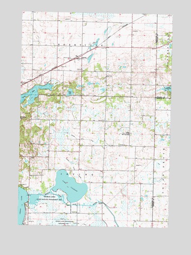
Hawick, MN USGS Topographic Map
Click on map above to begin viewing in our Map Viewer.

This topographic map contains these locations and features:
Feature Name Type Latitude Longitude GNIS ID View Map
Calhoun Lake DamDamN45.2633°W94.8320°1775994View Map
Calhoun Lake Diversion DamDamN45.2633°W94.8353°1775996View Map
Calhoun Lake West DamDamN45.2683°W94.8470°1776012View Map
County Ditch Number NineCanalN45.2514°W94.8211°642367View Map
County Ditch Number TwentysixCanalN45.3022°W94.8400°641872View Map
Crow River ReservoirReservoirN45.2633°W94.8353°1775997View Map
Dietrich Lange State Wildlife Management AreParkN45.2658°W94.8467°642814View Map
East Irving MissionChurchN45.3044°W94.7842°643083View Map
Evangelical Free Church CemeteryCemeteryN45.3050°W94.7894°2067766View Map
Green LakeReservoirN45.2666°W94.8670°1776516View Map
Green Lake DamDamN45.2666°W94.8670°1776515View Map
HawickPopulated PlaceN45.3477°W94.8272°644735View Map
Hawick (historical)LocaleN45.3486°W94.8278°2067776View Map
Hawick Post OfficePost OfficeN45.3478°W94.8269°2067777View Map
Lake CalhounReservoirN45.2732°W94.8324°640737View Map
Long LakeLakeN45.3263°W94.8668°647113View Map
Nordland CemeteryCemeteryN45.2983°W94.7925°2067767View Map
Nordland ChurchChurchN45.2977°W94.7919°648589View Map
Old Wagon CampgroundLocaleN45.3278°W94.8694°2067778View Map
Otter LakeLakeN45.3281°W94.8338°649050View Map
Paynesville Evangelical ChurchChurchN45.3569°W94.7625°2067996View Map
Powers FarmsLocaleN45.3072°W94.8306°2664403View Map
Roseville CemeteryCemeteryN45.3484°W94.8348°650299View Map
School Number 769SchoolN45.3050°W94.7842°651731View Map
School Number 783SchoolN45.2577°W94.8261°651738View Map
School Number 812SchoolN45.3375°W94.8039°651746View Map
Township of IrvingCivilN45.2826°W94.8248°664558View Map
Township of RosevilleCivilN45.3691°W94.8245°665469View Map
Zion ChurchChurchN45.3119°W94.8067°654477View Map
Zion Irving Lutheran CemeteryCemeteryN45.3124°W94.8069°2067768View Map

Note: Coordinates in the location and feature list above are referenced to NAD83 datum.


Copyright (C) 2008-2024 Ryan Niemi / Sunset Dynamics ... All Rights Reserved