TopoQuest Logo
Do you find TopoQuest useful?
Help keep TopoQuest running and adding new maps/features by donating!
Bitcoin:  19c7KJd3qBynnjoSw5npx9KScwjBe4ifkT
Litecoin:  LXs6TkuXGGXo1vDsWCkWVdjQX94eUKd6ui
Home View Maps Find Maps Find Places Resources & Links


Gin Branch, Mississippi Topographic Map

USGS Map Title: Gin Branch, MS
USGS Map MRC: 31090F8
DRG (GeoTIFF) Download: o31090f8.tif


Neighboring USGS Topographic Map Quads:


  Lorman, MS  
31091G1
 

  Red Lick, MS  
31090G8
 

  McBride, MS  
31090G7
 

  Fayette, MS  
31091F1
 

  Gin Branch, MS  
31090F8
 

  Union Church, MS  
31090F7
 

  Roxie, MS  
31091E1
 

  Kirby, MS  
31090E8
 

  Eddiceton, MS  
31090E7


Map MRC Location:

N32°
W91°
N32°
W90°
H8 H7 H6 H5 H4 H3 H2 H1
G8 G7 G6 G5 G4 G3 G2 G1
F8 F7 F6 F5 F4 F3 F2 F1
E8 E7 E6 E5 E4 E3 E2 E1
D8 D7 D6 D5 D4 D3 D2 D1
C8 C7 C6 C5 C4 C3 C2 C1
B8 B7 B6 B5 B4 B3 B2 B1
A8 A7 A6 A5 A4 A3 A2 A1
N31°
W91°
N31°
W90°

Gin Branch, MS USGS 1:24K Topographic Map Preview:
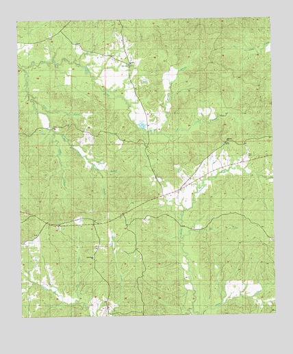
Gin Branch, MS USGS Topographic Map
Click on map above to begin viewing in our Map Viewer.

This topographic map contains these locations and features:
Feature Name Type Latitude Longitude GNIS ID View Map
Bethesda ChurchChurchN31.6982°W90.8973°666970View Map
Charlie Humphreys Catfish Ponds DamDamN31.7118°W90.9584°680843View Map
Crown Point ChurchChurchN31.6496°W90.9648°668991View Map
Dillon CemeteryCemeteryN31.7302°W90.9454°669268View Map
Ebenezer ChurchChurchN31.6635°W90.9595°669643View Map
Ephesus ChurchChurchN31.7313°W90.9454°669796View Map
Frog BranchStreamN31.6913°W90.9670°670258View Map
Gin BranchStreamN31.6568°W90.9198°670406View Map
JeffersonPopulated PlaceN31.6632°W90.9834°689813View Map
McDonald BranchStreamN31.7027°W90.9826°673331View Map
Mill CreekStreamN31.6313°W90.9726°673599View Map
Neigh BranchStreamN31.7168°W90.9929°674546View Map
Puffer BranchStreamN31.7027°W90.9829°676412View Map
Ross BranchStreamN31.7018°W90.9304°676885View Map
Shady Grove ChurchChurchN31.7196°W90.9423°677559View Map
Supervisor District 2CivilN31.7338°W90.9733°711910View Map
Tanyard BranchStreamN31.6913°W90.9670°678562View Map
Terry CreekStreamN31.7296°W90.9993°678649View Map

Note: Coordinates in the location and feature list above are referenced to NAD83 datum.


Copyright (C) 2008-2024 Ryan Niemi / Sunset Dynamics ... All Rights Reserved