TopoQuest Logo
Do you find TopoQuest useful?
Help keep TopoQuest running and adding new maps/features by donating!
Bitcoin:  19c7KJd3qBynnjoSw5npx9KScwjBe4ifkT
Litecoin:  LXs6TkuXGGXo1vDsWCkWVdjQX94eUKd6ui
Home View Maps Find Maps Find Places Resources & Links


Gate City, Virginia Topographic Map

USGS Map Title: Gate City, VA
USGS Map MRC: 36082F5
DRG (GeoTIFF) Download: o36082f5.tif


Neighboring USGS Topographic Map Quads:


  East Stone Gap, VA  
36082G6
 

  Fort Blackmore, VA  
36082G5
 

  Dungannon, VA  
36082G4
 

  Clinchport, VA  
36082F6
 

  Gate City, VA  
36082F5
 

  Hiltons, VA  
36082F4
 

  Church Hill, TN  
36082E6
 

  Kingsport, TN  
36082E5
 

  Indian Springs, TN  
36082E4


Map MRC Location:

N37°
W83°
N37°
W82°
H8 H7 H6 H5 H4 H3 H2 H1
G8 G7 G6 G5 G4 G3 G2 G1
F8 F7 F6 F5 F4 F3 F2 F1
E8 E7 E6 E5 E4 E3 E2 E1
D8 D7 D6 D5 D4 D3 D2 D1
C8 C7 C6 C5 C4 C3 C2 C1
B8 B7 B6 B5 B4 B3 B2 B1
A8 A7 A6 A5 A4 A3 A2 A1
N36°
W83°
N36°
W82°

Gate City, VA USGS 1:24K Topographic Map Preview:
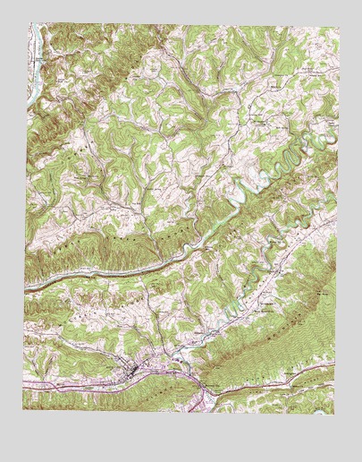
Gate City, VA USGS Topographic Map
Click on map above to begin viewing in our Map Viewer.

This topographic map contains these locations and features:
Feature Name Type Latitude Longitude GNIS ID View Map
Abijah Alley CemeteryCemeteryN36.6887°W82.5768°1498022View Map
Addington StoreLocaleN36.7012°W82.5507°1462368View Map
Alley ValleyLocaleN36.6918°W82.5921°1462418View Map
Alley ValleyValleyN36.6732°W82.5694°1462419View Map
Alley Valley CemeteryCemeteryN36.6882°W82.6018°2774725View Map
Antioch ChurchChurchN36.6704°W82.5240°1462493View Map
Big KnobSummitN36.6623°W82.5060°1463369View Map
Big SpringSpringN36.7007°W82.6006°1463412View Map
Blair CemeteryCemeteryN36.6709°W82.5981°1463543View Map
Blue Water PondLakeN36.7355°W82.5133°1463597View Map
Buck SpringSpringN36.7001°W82.6006°1463998View Map
Burnt Cabin BranchStreamN36.6359°W82.5813°1464127View Map
Carrico MillPopulated PlaceN36.7212°W82.5357°1494864View Map
Carter CemeteryCemeteryN36.6706°W82.5918°1464471View Map
Carter CemeteryCemeteryN36.7492°W82.6190°1464472View Map
Chapman BranchStreamN36.6840°W82.5224°1464746View Map
Church of ChristChurchN36.6420°W82.5863°1498052View Map
Copper Creek BluffCliffN36.6682°W82.6046°1482701View Map
Cove CreekStreamN36.7495°W82.6227°1482738View Map
Cox MillPopulated PlaceN36.6920°W82.5793°1494891View Map
Culbutson CemeteryCemeteryN36.6945°W82.5213°1465515View Map
Davidson CemeteryCemeteryN36.6898°W82.6107°1465629View Map
Davidson CemeteryCemeteryN36.7339°W82.6030°1465630View Map
Davidson HollowValleyN36.6910°W82.6162°1465631View Map
Dingus CemeteryCemeteryN36.7441°W82.5362°2766666View Map
District 4CivilN36.6465°W82.6181°1927253View Map
Dougherty CemeteryCemeteryN36.7187°W82.5079°2766668View Map
Dry HollowValleyN36.7406°W82.5620°1483123View Map
Egan CemeteryCemeteryN36.6900°W82.6192°1466195View Map
Elam CemeteryCemeteryN36.7229°W82.5009°2766671View Map
Elliott CemeteryCemeteryN36.7047°W82.5011°2766672View Map
Estill CemeteryCemeteryN36.6379°W82.5829°1498064View Map
Farley ChapelChurchN36.7198°W82.5027°1466486View Map
Flower BranchStreamN36.6690°W82.5938°1466734View Map
Franklin BranchStreamN36.6504°W82.5524°1466848View Map
Frazier CemeteryCemeteryN36.7300°W82.5822°1466859View Map
Frederick Starnes CemeteryCemeteryN36.7257°W82.6122°1475083View Map
Gate CityPopulated PlaceN36.6379°W82.5810°1498481View Map
Gate City Baptist ChurchChurchN36.6368°W82.5818°1498079View Map
Gate City High SchoolSchoolN36.6397°W82.5687°1498080View Map
Gate City Middle SchoolSchoolN36.6391°W82.5700°1498081View Map
Gate City Police DepartmentBuildingN36.6396°W82.5789°2767095View Map
Gate City Post OfficePost OfficeN36.6425°W82.5705°1499030View Map
Gate City Town HallBuildingN36.6393°W82.5793°1498082View Map
Gate City United Methodist ChurchChurchN36.6387°W82.5813°1498083View Map
Gate City Volunteer Fire DepartmentBuildingN36.6393°W82.5727°2085982View Map
Gibson Family CemeteryCemeteryN36.6992°W82.5028°2766701View Map
Gillenwater BranchStreamN36.7215°W82.5521°1487047View Map
Gillenwater CemeteryCemeteryN36.7269°W82.5522°2766702View Map
Gillenwaters CemeteryCemeteryN36.7415°W82.5612°2766703View Map
Gilmore HollowValleyN36.7290°W82.5464°1467107View Map
Hale SpringSpringN36.7172°W82.5201°1467649View Map
Irvington ChurchChurchN36.7340°W82.5260°1468522View Map
Jayne MillPopulated PlaceN36.6387°W82.5643°1495004View Map
Lark CreekStreamN36.6659°W82.6165°1469138View Map
Little Moccasin CreekStreamN36.6370°W82.5582°1484931View Map
Little Poor ValleyBasinN36.6340°W82.5077°1469620View Map
Lydia ChurchChurchN36.6309°W82.5185°1469941View Map
MarcemPopulated PlaceN36.6304°W82.6085°1495052View Map
McConnell CemeteryCemeteryN36.7003°W82.5342°2766669View Map
McConnell ChurchChurchN36.7051°W82.5460°1470235View Map
McDowell BranchStreamN36.7443°W82.6207°1470250View Map
Midway ChurchChurchN36.7298°W82.5271°1470432View Map
Midway SchoolSchoolN36.7340°W82.5132°1470441View Map
Mineral Hill ChurchChurchN36.6798°W82.5274°1470600View Map
Moccasin GapLocaleN36.6332°W82.5521°1470650View Map
Moccasin SidingLocaleN36.6309°W82.5463°1470651View Map
Moccasin ValleyValleyN36.6420°W82.5628°1470652View Map
Moore Memorial ChurchChurchN36.6584°W82.5332°1470712View Map
Mount Pleasant ChurchChurchN36.7184°W82.5299°1471029View Map
Mount View SchoolSchoolN36.6607°W82.5302°1471107View Map
Newton HollowValleyN36.6352°W82.6163°1471525View Map
NottinghamPopulated PlaceN36.6354°W82.5149°1495076View Map
Obeys CreekStreamN36.6807°W82.5535°1485949View Map
Obies Creek Mill (historical)LocaleN36.7157°W82.5574°1498134View Map
Peters BranchStreamN36.7132°W82.5571°1472223View Map
Peters CemeteryCemeteryN36.7170°W82.5479°1498145View Map
Peters HollowValleyN36.6354°W82.6165°1472231View Map
PikeStreamN36.6443°W82.5679°1472300View Map
Pine BranchStreamN36.7365°W82.5282°1472326View Map
Plank Camp CreekStreamN36.6729°W82.5693°1472460View Map
Prospect School (historical)SchoolN36.6429°W82.5871°1498154View Map
Quillin CemeteryCemeteryN36.6737°W82.5290°1472906View Map
Quillin CemeteryCemeteryN36.6951°W82.6204°1472907View Map
Quillin SpringSpringN36.6971°W82.5772°1472908View Map
R P Kane Athletic FieldParkN36.6412°W82.5754°1498157View Map
Red Hill BranchStreamN36.6429°W82.5654°1473048View Map
Red Hill ChurchChurchN36.6559°W82.5915°1473049View Map
Red Hill School (historical)SchoolN36.6557°W82.5915°1498160View Map
Salling CemeteryCemeteryN36.7498°W82.6249°1486896View Map
Sanders CemeteryCemeteryN36.7406°W82.6161°1473999View Map
Scott CountyCivilN36.7143°W82.6029°1498172View Map
Scott County Career and Technical CenterSchoolN36.6417°W82.5626°2498469View Map
Scott County CourthouseBuildingN36.6382°W82.5807°1498173View Map
Scott County JailBuildingN36.6386°W82.5808°2767134View Map
Scott County LibraryBuildingN36.6384°W82.5804°1498174View Map
Scott County Life Saving CrewBuildingN36.6360°W82.5828°2721028View Map
Scott County Sheriff's OfficeBuildingN36.6383°W82.5810°2766941View Map
Shoemaker Elementary SchoolSchoolN36.6401°W82.5753°1498178View Map
SlabtownPopulated PlaceN36.6501°W82.5504°1474662View Map
Slant ChurchChurchN36.7368°W82.6249°1487295View Map
Slant Post OfficePost OfficeN36.7348°W82.6235°1721375View Map
Smith CemeteryCemeteryN36.6476°W82.5576°1474724View Map
Solon Addington CemeteryCemeteryN36.6976°W82.5552°1498183View Map
Spencer Alley CemeteryCemeteryN36.6898°W82.5796°1498187View Map
Starnes Bluff ChurchChurchN36.7284°W82.6129°1475082View Map
Strong BranchStreamN36.7165°W82.5532°1475253View Map
Strong CemeteryCemeteryN36.6568°W82.5668°1475254View Map
Strong CemeteryCemeteryN36.7349°W82.5735°1475255View Map
Strong School (historical)SchoolN36.7301°W82.5704°1498195View Map
Town of Gate CityCivilN36.6402°W82.5783°2390201View Map
Union Church (historical)ChurchN36.7107°W82.6054°1498200View Map
Valley CreekStreamN36.7154°W82.5118°1488089View Map
Walnut Grove Church (historical)ChurchN36.7015°W82.6040°1498206View Map
Webber ChurchChurchN36.6340°W82.5177°1476427View Map
Weber City Police DepartmentBuildingN36.6279°W82.5540°2766990View Map
Weber City Post OfficePost OfficeN36.6276°W82.5540°1499031View Map
Weber City Town HallBuildingN36.6273°W82.5546°1498209View Map
WGAT-AM (Gate City)TowerN36.6332°W82.5821°1498936View Map
Widow BranchStreamN36.7262°W82.6213°1488356View Map
Williams HollowValleyN36.6610°W82.5415°1476766View Map
Williams MillPopulated PlaceN36.6770°W82.5518°1495171View Map
Wood CemeteryCemeteryN36.6459°W82.6249°1488470View Map

Note: Coordinates in the location and feature list above are referenced to NAD83 datum.


Copyright (C) 2008-2024 Ryan Niemi / Sunset Dynamics ... All Rights Reserved