TopoQuest Logo
Do you find TopoQuest useful?
Help keep TopoQuest running and adding new maps/features by donating!
Bitcoin:  19c7KJd3qBynnjoSw5npx9KScwjBe4ifkT
Litecoin:  LXs6TkuXGGXo1vDsWCkWVdjQX94eUKd6ui
Home View Maps Find Maps Find Places Resources & Links


Dungannon, Virginia Topographic Map

USGS Map Title: Dungannon, VA
USGS Map MRC: 36082G4
DRG (GeoTIFF) Download: o36082g4.tif


Neighboring USGS Topographic Map Quads:


  Wise, VA  
36082H5
 

  Coeburn, VA  
36082H4
 

  Saint Paul, VA  
36082H3
 

  Fort Blackmore, VA  
36082G5
 

  Dungannon, VA  
36082G4
 

  Moll Creek, VA  
36082G3
 

  Gate City, VA  
36082F5
 

  Hiltons, VA  
36082F4
 

  Mendota, VA  
36082F3


Map MRC Location:

N37°
W83°
N37°
W82°
H8 H7 H6 H5 H4 H3 H2 H1
G8 G7 G6 G5 G4 G3 G2 G1
F8 F7 F6 F5 F4 F3 F2 F1
E8 E7 E6 E5 E4 E3 E2 E1
D8 D7 D6 D5 D4 D3 D2 D1
C8 C7 C6 C5 C4 C3 C2 C1
B8 B7 B6 B5 B4 B3 B2 B1
A8 A7 A6 A5 A4 A3 A2 A1
N36°
W83°
N36°
W82°

Dungannon, VA USGS 1:24K Topographic Map Preview:
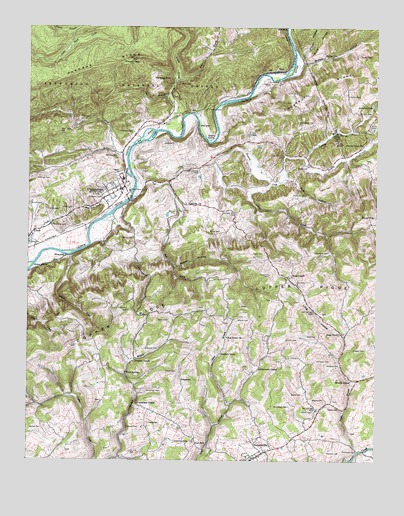
Dungannon, VA USGS Topographic Map
Click on map above to begin viewing in our Map Viewer.

This topographic map contains these locations and features:
Feature Name Type Latitude Longitude GNIS ID View Map
Baker BranchStreamN36.8593°W82.4474°1481402View Map
Bald RockSummitN36.8668°W82.4160°1498026View Map
Banner - Finch CemeteryCemeteryN36.8211°W82.4471°1481446View Map
Barb HollowValleyN36.8314°W82.4076°1481451View Map
Beaver HollowValleyN36.8059°W82.4475°1481565View Map
Benges CreekStreamN36.8090°W82.4857°1481623View Map
Bickley CemeteryCemeteryN36.8132°W82.4990°1481690View Map
Big Spring BranchStreamN36.7857°W82.3865°1498032View Map
Bill Osborne CemeteryCemeteryN36.8406°W82.4718°1498033View Map
Buffalo CemeteryCemeteryN36.8673°W82.3813°1482144View Map
Buffalo ChurchChurchN36.8665°W82.3932°1482145View Map
Buffalo HollowValleyN36.8650°W82.4023°1482151View Map
Bush MillPopulated PlaceN36.7557°W82.4354°1492684View Map
Castle CemeteryCemeteryN36.7693°W82.4013°1482369View Map
Castle CemeteryCemeteryN36.7906°W82.4493°1482370View Map
Chesnut RidgeRidgeN36.8609°W82.3913°1487039View Map
Childress CemeteryCemeteryN36.8454°W82.4626°1482514View Map
ClinchPopulated PlaceN36.8165°W82.4977°1492782View Map
Compton CemeteryCemeteryN36.7823°W82.4576°1482677View Map
Corder CemeteryCemeteryN36.8243°W82.4993°1482707View Map
Cowan CreekStreamN36.8295°W82.4132°1482755View Map
Cox CemeteryCemeteryN36.7968°W82.4288°1482768View Map
Cox CemeteryCemeteryN36.8012°W82.4021°1482769View Map
Crackers NeckPopulated PlaceN36.7807°W82.4307°1492815View Map
Culbertson CemeteryCemeteryN36.7554°W82.4471°1482873View Map
Culbertson CemeteryCemeteryN36.8104°W82.3976°1482874View Map
Culbertson CemeteryCemeteryN36.7774°W82.4208°2766700View Map
Culbertson ChapelChurchN36.7662°W82.4602°1482876View Map
Dingus CemeteryCemeteryN36.8082°W82.3916°2766663View Map
Dingus CemeteryCemeteryN36.7846°W82.4400°2766665View Map
Dockery ChapelChurchN36.7793°W82.4613°1483044View Map
Dougherty CemeteryCemeteryN36.7536°W82.4700°1498060View Map
Dry CreekStreamN36.8387°W82.4646°1483113View Map
DungannonPopulated PlaceN36.8284°W82.4724°1483171View Map
Dungannon Intermediate SchoolSchoolN36.8313°W82.4661°1498062View Map
Dungannon Post OfficePost OfficeN36.8272°W82.4683°2766454View Map
Dungannon Volunteer Fire DepartmentBuildingN36.8266°W82.4716°2085981View Map
Elam CemeteryCemeteryN36.8342°W82.4951°1483256View Map
Fall CreekStreamN36.8257°W82.4629°1483347View Map
Family CemeteryCemeteryN36.8582°W82.4082°2766678View Map
Fields CemeteryCemeteryN36.8245°W82.4839°2766681View Map
Fincastle ChurchChurchN36.8243°W82.4432°1483415View Map
Fincastle Church CemeteryCemeteryN36.8244°W82.4433°2766684View Map
Garfield School (historical)SchoolN36.7570°W82.4560°1498078View Map
Gillenwater ChapelChurchN36.7768°W82.4163°1483628View Map
Gillespie CemeteryCemeteryN36.7593°W82.4552°2766704View Map
Gillespie CemeteryCemeteryN36.7593°W82.4601°1483629View Map
Grigbys StorePopulated PlaceN36.7857°W82.3863°1498092View Map
Grigsby CemeteryCemeteryN36.7823°W82.3788°1483839View Map
Hanging RockPillarN36.8595°W82.4540°1483925View Map
Hanging Rock Recreation SiteLocaleN36.8579°W82.4485°1498570View Map
Hartsock CemeteryCemeteryN36.7773°W82.3879°1495661View Map
Hartsock CemeteryCemeteryN36.7793°W82.3910°1495662View Map
Hartsock CemeteryCemeteryN36.7526°W82.3874°1483962View Map
Hartsock CemeteryCemeteryN36.8265°W82.4001°1483963View Map
Hillman CemeteryCemeteryN36.7645°W82.3971°1484114View Map
Hillman CemeteryCemeteryN36.8312°W82.4965°1484115View Map
Jack BranchStreamN36.8551°W82.4499°1484377View Map
Jessee BranchStreamN36.7529°W82.3813°1484440View Map
Jessee CemeteryCemeteryN36.7657°W82.3915°1484441View Map
Kerns Chapel (historical)ChurchN36.7520°W82.4904°1498104View Map
Kilgore CemeteryCemeteryN36.7859°W82.4146°1498105View Map
Kilgore CemeteryCemeteryN36.7682°W82.3932°1484588View Map
Kilgore CemeteryCemeteryN36.7912°W82.4204°1484589View Map
Little Stony CreekStreamN36.8454°W82.4527°1484985View Map
Long HollowValleyN36.7856°W82.3861°1485054View Map
Lucas CemeteryCemeteryN36.8195°W82.4910°1498108View Map
Lucas CemeteryCemeteryN36.8231°W82.4840°1485124View Map
McConnell CemeteryCemeteryN36.7659°W82.4060°1485270View Map
McConnell CemeteryCemeteryN36.7701°W82.4574°1485271View Map
Meade CemeteryCemeteryN36.7609°W82.4563°1485319View Map
Meades ChapelChurchN36.7732°W82.3838°1485324View Map
Mighty BranchStreamN36.7780°W82.4634°2786137View Map
Mill IslandIslandN36.8434°W82.4579°1485446View Map
Miller YardLocaleN36.8623°W82.4149°1485472View Map
Mountain LakeReservoirN36.8526°W82.3765°1485679View Map
Mountain View School (historical)SchoolN36.8593°W82.4107°1498122View Map
Muttonhead HollowValleyN36.7692°W82.4741°1498124View Map
New Bethel ChurchChurchN36.7857°W82.4282°1485834View Map
New Bethel School (historical)SchoolN36.7854°W82.4285°1498127View Map
NickelsvillePopulated PlaceN36.7529°W82.4146°1493348View Map
Nickelsville Baptist Church CemeteryCemeteryN36.7506°W82.4191°2766685View Map
Nickelsville Elementary SchoolSchoolN36.7502°W82.4222°1498132View Map
Nickelsville Post OfficePost OfficeN36.7531°W82.4156°2767242View Map
Nickelsville Rescue SquadBuildingN36.7515°W82.4155°2085973View Map
Nickelsville Volunteer Fire DepartmentBuildingN36.7519°W82.4159°2085972View Map
Odell CemeteryCemeteryN36.7865°W82.3960°1485950View Map
Old Rocklands School (historical)SchoolN36.7537°W82.4882°1498135View Map
Osborne CemeteryCemeteryN36.8229°W82.4935°1485999View Map
Osborne CemeteryCemeteryN36.8384°W82.4682°1486001View Map
Osborne RidgeRidgeN36.8651°W82.4729°1486004View Map
Osborne-Taylor CemeteryCemeteryN36.8568°W82.4493°1498137View Map
Patrick Hogan Osborne CemeteryCemeteryN36.8318°W82.4679°1498197View Map
Pendleton CemeteryCemeteryN36.8179°W82.4913°1486127View Map
Pentecostal ChurchChurchN36.7501°W82.4854°1472194View Map
Phillips CemeteryCemeteryN36.8501°W82.3815°1486178View Map
Pippin CemeteryCemeteryN36.8098°W82.4151°1472435View Map
Point Truth ChurchChurchN36.7870°W82.3865°1486311View Map
Poplar HollowValleyN36.8662°W82.4028°1486356View Map
Porter CemeteryCemeteryN36.8351°W82.3999°1486363View Map
Porter CemeteryCemeteryN36.8465°W82.3765°1486364View Map
Porter CemeteryCemeteryN36.8557°W82.3851°1486365View Map
Pound GapGapN36.8645°W82.4663°1486394View Map
Powers CemeteryCemeteryN36.8443°W82.4204°1498150View Map
Powers CemeteryCemeteryN36.8595°W82.4138°1486413View Map
Price CemeteryCemeteryN36.8237°W82.3896°1498151View Map
Ramey CemeteryCemeteryN36.8159°W82.4307°1486494View Map
Ramey CemeteryCemeteryN36.8512°W82.4429°1498158View Map
Ramsey CemeteryCemeteryN36.8551°W82.4493°1498159View Map
Roaring BranchStreamN36.8376°W82.4007°1486654View Map
Salyer CemeteryCemeteryN36.7965°W82.4124°1498170View Map
Scott County Life Saving CrewBuildingN36.8295°W82.4660°2768992View Map
Sergent CemeteryCemeteryN36.8479°W82.4021°1487000View Map
Sinking CreekStreamN36.8254°W82.4307°1487259View Map
Sinking Creek ChurchChurchN36.8412°W82.3799°1487262View Map
Sinking SpringSpringN36.8426°W82.4346°1487264View Map
Sluss CemeteryCemeteryN36.8479°W82.4732°1498181View Map
Stallard CemeteryCemeteryN36.8120°W82.4621°1498189View Map
Stallard CemeteryCemeteryN36.7590°W82.4940°1487506View Map
Stapleton CemeteryCemeteryN36.8265°W82.4735°1487523View Map
StonyPopulated PlaceN36.8468°W82.4538°1498194View Map
StringtownPopulated PlaceN36.7734°W82.4449°1493664View Map
Sunny PointPopulated PlaceN36.8201°W82.3760°1493674View Map
Thompson FordCrossingN36.7523°W82.3818°1493702View Map
Titan RunStreamN36.7790°W82.4615°2786138View Map
Town of DungannonCivilN36.8284°W82.4681°2390153View Map
Town of NickelsvilleCivilN36.7516°W82.4160°2391331View Map
Townes TunnelTunnelN36.8523°W82.4349°1487970View Map
Turner CemeteryCemeteryN36.7851°W82.4071°1488038View Map
Twin SpringsPopulated PlaceN36.7748°W82.4643°1493727View Map
Twin Springs High SchoolSchoolN36.7797°W82.4633°2498435View Map
Twin Springs School (historical)SchoolN36.7745°W82.4649°1498199View Map
Vicars CemeteryCemeteryN36.7762°W82.4463°1488129View Map
Virginia State Prison CampLocaleN36.8276°W82.4632°1493868View Map
Wells ChapelChurchN36.8037°W82.4049°1488230View Map
Williams-Kilgore CemeteryCemeteryN36.7898°W82.4299°1498393View Map
Wolf Run CreekStreamN36.8212°W82.4718°1488456View Map
Wolfe CemeteryCemeteryN36.8143°W82.4621°1488458View Map
Wolfe CemeteryCemeteryN36.8604°W82.4471°1498216View Map

Note: Coordinates in the location and feature list above are referenced to NAD83 datum.


Copyright (C) 2008-2024 Ryan Niemi / Sunset Dynamics ... All Rights Reserved