TopoQuest Logo
Do you find TopoQuest useful?
Help keep TopoQuest running and adding new maps/features by donating!
Bitcoin:  19c7KJd3qBynnjoSw5npx9KScwjBe4ifkT
Litecoin:  LXs6TkuXGGXo1vDsWCkWVdjQX94eUKd6ui
Home View Maps Find Maps Find Places Resources & Links


Fulshear, Texas Topographic Map

USGS Map Title: Fulshear, TX
USGS Map MRC: 29095F8
DRG (GeoTIFF) Download: o29095f8.tif


Neighboring USGS Topographic Map Quads:


  San Felipe, TX  
29096G1
 

  Brookshire, TX  
29095G8
 

  Katy, TX  
29095G7
 

  Wallis, TX  
29096F1
 

  Fulshear, TX  
29095F8
 

  Richmond NE, TX  
29095F7
 

  East Bernard, TX  
29096E1
 

  Orchard, TX  
29095E8
 

  Richmond, TX  
29095E7


Map MRC Location:

N30°
W96°
N30°
W95°
H8 H7 H6 H5 H4 H3 H2 H1
G8 G7 G6 G5 G4 G3 G2 G1
F8 F7 F6 F5 F4 F3 F2 F1
E8 E7 E6 E5 E4 E3 E2 E1
D8 D7 D6 D5 D4 D3 D2 D1
C8 C7 C6 C5 C4 C3 C2 C1
B8 B7 B6 B5 B4 B3 B2 B1
A8 A7 A6 A5 A4 A3 A2 A1
N29°
W96°
N29°
W95°

Fulshear, TX USGS 1:24K Topographic Map Preview:
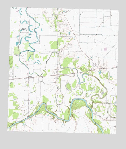
Fulshear, TX USGS Topographic Map
Click on map above to begin viewing in our Map Viewer.

This topographic map contains these locations and features:
Feature Name Type Latitude Longitude GNIS ID View Map
Baytown Medical Center HeliportAirportN29.7475°W95.9463°1386211View Map
Bessies CreekStreamN29.6494°W95.9036°1372511View Map
Bob Lutts Fulshear/Simonton Branch LibraryBuildingN29.6944°W95.9011°2015332View Map
Brookshire CreekStreamN29.7050°W95.9430°1331327View Map
City of FulshearCivilN29.6482°W95.8961°2410557View Map
City of SimontonCivilN29.6771°W95.9764°2411905View Map
City of Weston LakesCivilN29.6628°W95.9352°2518808View Map
Cottonwood CreekStreamN29.6566°W95.9022°1333440View Map
Fendley Airport (historical)AirportN29.6880°W95.9397°1386702View Map
FulshearPopulated PlaceN29.6900°W95.8997°1336299View Map
Fulshear City HallBuildingN29.6884°W95.9010°2753689View Map
Fulshear LakeLakeN29.6864°W95.8956°1336300View Map
Fulshear Police DepartmentBuildingN29.6884°W95.9010°2375835View Map
Fulshear Post OfficePost OfficeN29.6954°W95.9004°2731482View Map
Fulshear Simonton Fire Department Station 1BuildingN29.6952°W95.9026°2334343View Map
Fulshear Simonton Fire Department Station 2BuildingN29.6795°W95.9725°2655608View Map
Jerusalem Starlight ChurchChurchN29.6808°W95.9444°1338719View Map
Little Prayer CemeteryCemeteryN29.6800°W95.9438°1340154View Map
Pittsville (historical)Populated PlaceN29.7230°W95.9252°2747936View Map
Pleasant HillPopulated PlaceN29.6550°W95.8913°1378882View Map
Pleasant Hill ChurchChurchN29.6555°W95.8825°1344211View Map
Pool HillSummitN29.6838°W95.9455°1344351View Map
Saint Johns ChurchChurchN29.6455°W95.9375°1345942View Map
Saint Mathews ChurchChurchN29.6805°W95.9613°1346044View Map
Saint Pauls ChurchChurchN29.6611°W95.9625°1346087View Map
SimontonPopulated PlaceN29.6794°W95.9772°1347151View Map
Simonton Post OfficePost OfficeN29.6801°W95.9788°2731355View Map
Weston LakesPopulated PlaceN29.6832°W95.9357°2518811View Map
Weston Lakes Country ClubLocaleN29.6817°W95.9365°2518813View Map
White Wing Ranch AirportAirportN29.6400°W95.9678°1387269View Map
Zion ChapelChurchN29.7072°W95.9400°1350742View Map

Note: Coordinates in the location and feature list above are referenced to NAD83 datum.


Copyright (C) 2008-2024 Ryan Niemi / Sunset Dynamics ... All Rights Reserved