TopoQuest Logo
Do you find TopoQuest useful?
Help keep TopoQuest running and adding new maps/features by donating!
Bitcoin:  19c7KJd3qBynnjoSw5npx9KScwjBe4ifkT
Litecoin:  LXs6TkuXGGXo1vDsWCkWVdjQX94eUKd6ui
Home View Maps Find Maps Find Places Resources & Links


Richmond NE, Texas Topographic Map

USGS Map Title: Richmond NE, TX
USGS Map MRC: 29095F7
DRG (GeoTIFF) Download: o29095f7.tif


Neighboring USGS Topographic Map Quads:


  Brookshire, TX  
29095G8
 

  Katy, TX  
29095G7
 

  Addicks, TX  
29095G6
 

  Fulshear, TX  
29095F8
 

  Richmond NE, TX  
29095F7
 

  Clodine, TX  
29095F6
 

  Orchard, TX  
29095E8
 

  Richmond, TX  
29095E7
 

  Sugar Land, TX  
29095E6


Map MRC Location:

N30°
W96°
N30°
W95°
H8 H7 H6 H5 H4 H3 H2 H1
G8 G7 G6 G5 G4 G3 G2 G1
F8 F7 F6 F5 F4 F3 F2 F1
E8 E7 E6 E5 E4 E3 E2 E1
D8 D7 D6 D5 D4 D3 D2 D1
C8 C7 C6 C5 C4 C3 C2 C1
B8 B7 B6 B5 B4 B3 B2 B1
A8 A7 A6 A5 A4 A3 A2 A1
N29°
W96°
N29°
W95°

Richmond NE, TX USGS 1:24K Topographic Map Preview:
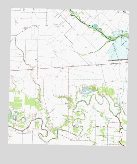
Richmond NE, TX USGS Topographic Map
Click on map above to begin viewing in our Map Viewer.

This topographic map contains these locations and features:
Feature Name Type Latitude Longitude GNIS ID View Map
Briscoe CemeteryCemeteryN29.6488°W95.8138°1331274View Map
Cardiff Brothers Airport (historical)AirportN29.7294°W95.8497°1386982View Map
Cinco RanchPopulated PlaceN29.7388°W95.7580°1852694View Map
Cinco Ranch Census Designated PlaceCensusN29.7395°W95.7608°2407623View Map
Cinco Ranch High SchoolSchoolN29.7437°W95.7725°2472534View Map
Covey Trails AirportAirportN29.6900°W95.8397°1386701View Map
Dewberry HeliportAirportN29.7333°W95.8638°1386986View Map
Flewellen CreekStreamN29.6475°W95.8491°1335954View Map
Fort Bend County Constable's Office Precinct 3BuildingN29.7036°W95.7718°2751467View Map
Fort Bend County Emergency Service District 2 Medic 9BuildingN29.7407°W95.7881°2720927View Map
Fort Bend WCID 1 Old Second Lift DamDamN29.6600°W95.7567°1857323View Map
FosterPopulated PlaceN29.6505°W95.8322°1378315View Map
Fulshear Oil FieldOilfieldN29.7397°W95.8188°1336301View Map
Fulshear-Simonton DivisionCivilN29.6851°W95.8629°1938760View Map
George Ranch Historical Park MuseumBuildingN29.6363°W95.8125°2014155View Map
Goss CemeteryCemeteryN29.6380°W95.8663°1336747View Map
Grace Community Bible ChurchChurchN29.6325°W95.8138°2018781View Map
Grace Fellowship United Methdist ChurchChurchN29.7448°W95.7515°2471609View Map
Heritage Ranch Airport (historical)AirportN29.6534°W95.8309°1387395View Map
Huntington MoundSummitN29.6308°W95.8747°1338314View Map
KMIA-FM (Rosenberg)TowerN29.6713°W95.7572°1388072View Map
Little ProngStreamN29.7225°W95.7688°1340155View Map
Living Word Lutheran ChurchChurchN29.7336°W95.7547°2018812View Map
McCrary LakeLakeN29.6502°W95.7709°1341170View Map
Oak HillSummitN29.6641°W95.7527°1342986View Map
Oak Hill ChurchChurchN29.6658°W95.7558°1342989View Map
Pageville ChurchChurchN29.6347°W95.7750°1343423View Map
Rodger and Ellen Beck Junior High SchoolSchoolN29.7205°W95.7524°2006822View Map
Roosevelt Alexander Elementary SchoolSchoolN29.7111°W95.7637°2472606View Map
Roosevelt Alexander Elementary SchoolSchoolN29.7125°W95.7654°2006823View Map
Saint John Old South Anglican Catholic ChurchChurchN29.6670°W95.7585°2471123View Map
Spring Green ChurchChurchN29.6633°W95.8161°1347733View Map
Swinging Door HeliportAirportN29.6275°W95.7694°1387394View Map
The Church Fellowship - Cinco RanchChurchN29.7497°W95.7691°2018777View Map
The Museum of Southern HistoryBuildingN29.6269°W95.7683°2014157View Map
West Cinco Ranch LakeReservoirN29.7369°W95.7886°1857325View Map
West Cinco Ranch Lake DamDamN29.7369°W95.7886°1857324View Map
Westheimer Air ParkAirportN29.6958°W95.7965°1386876View Map
Wilderness ChurchChurchN29.6297°W95.8072°1350080View Map

Note: Coordinates in the location and feature list above are referenced to NAD83 datum.


Copyright (C) 2008-2024 Ryan Niemi / Sunset Dynamics ... All Rights Reserved