TopoQuest Logo
Do you find TopoQuest useful?
Help keep TopoQuest running and adding new maps/features by donating!
Bitcoin:  19c7KJd3qBynnjoSw5npx9KScwjBe4ifkT
Litecoin:  LXs6TkuXGGXo1vDsWCkWVdjQX94eUKd6ui
Home View Maps Find Maps Find Places Resources & Links


Ashland, Georgia Topographic Map

USGS Map Title: Ashland, GA
USGS Map MRC: 34083C3
DRG (GeoTIFF) Download: o34083c3.tif


Neighboring USGS Topographic Map Quads:


  Lake Russell, GA  
34083D4
 

  Red Hill, GA  
34083D3
 

  Martin, GA  
34083D2
 

  Homer, GA  
34083C4
 

  Ashland, GA  
34083C3
 

  Carnesville, GA  
34083C2
 

  Commerce, GA  
34083B4
 

  Ila, GA  
34083B3
 

  Danielsville North, GA  
34083B2


Map MRC Location:

N35°
W84°
N35°
W83°
H8 H7 H6 H5 H4 H3 H2 H1
G8 G7 G6 G5 G4 G3 G2 G1
F8 F7 F6 F5 F4 F3 F2 F1
E8 E7 E6 E5 E4 E3 E2 E1
D8 D7 D6 D5 D4 D3 D2 D1
C8 C7 C6 C5 C4 C3 C2 C1
B8 B7 B6 B5 B4 B3 B2 B1
A8 A7 A6 A5 A4 A3 A2 A1
N34°
W84°
N34°
W83°

Ashland, GA USGS 1:24K Topographic Map Preview:
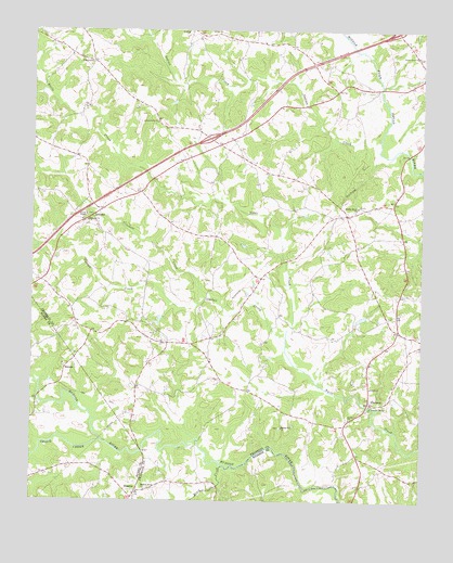
Ashland, GA USGS Topographic Map
Click on map above to begin viewing in our Map Viewer.

This topographic map contains these locations and features:
Feature Name Type Latitude Longitude GNIS ID View Map
Alston DamDamN34.2918°W83.2749°338742View Map
Alston LakeReservoirN34.2988°W83.2690°339205View Map
Alston LakeReservoirN34.2923°W83.2742°338743View Map
Alston Lake DamDamN34.2984°W83.2699°339204View Map
Arnold ChapelChurchN34.3259°W83.3574°310630View Map
AshlandPopulated PlaceN34.3257°W83.3557°331057View Map
Bald Springs ChurchChurchN34.2948°W83.3349°349308View Map
Black CreekStreamN34.2593°W83.3132°311474View Map
Bold Springs Fire DepartmentBuildingN34.2927°W83.3308°2604412View Map
Carlan CreekStreamN34.2901°W83.2932°354993View Map
Crockett CreekStreamN34.3043°W83.3190°313124View Map
CromersPopulated PlaceN34.2759°W83.2654°355378View Map
Cromers Mill Covered BridgeBridgeN34.2751°W83.2660°349315View Map
Ebenezer CemeteryCemeteryN34.3237°W83.3571°349319View Map
Ebenezer ChurchChurchN34.3243°W83.3571°313843View Map
ErastusPopulated PlaceN34.2526°W83.3410°326270View Map
Exit 55CrossingN34.3465°W83.3182°1704998View Map
Exit 56CrossingN34.3748°W83.2579°1704999View Map
Gordon ChurchChurchN34.2721°W83.2727°314713View Map
Grove CreekStreamN34.2657°W83.3521°356118View Map
HebronPopulated PlaceN34.2848°W83.3643°331945View Map
Hebron Academy (historical)SchoolN34.2868°W83.3652°349263View Map
Hebron CemeteryCemeteryN34.2857°W83.3643°349264View Map
Hebron ChurchChurchN34.2862°W83.3649°349265View Map
Hudson River ChurchChurchN34.2529°W83.3379°315793View Map
Hudson River LandingAirportN34.2604°W83.2865°2625391View Map
Indian CreekStreamN34.3437°W83.2640°328273View Map
Indian Creek ChurchChurchN34.3507°W83.3349°315902View Map
McIntires BridgeBridgeN34.2634°W83.3393°349276View Map
Melvin Hill ChurchChurchN34.2698°W83.2943°318012View Map
Middle River ChurchChurchN34.3282°W83.2702°318090View Map
Nails Creek Church (historical)ChurchN34.2843°W83.2665°349340View Map
PlainviewPopulated PlaceN34.3668°W83.3560°332703View Map
Ragsdale CreekStreamN34.3618°W83.3732°329355View Map
Sandy Cross DivisionCivilN34.2930°W83.2715°1936527View Map
Trinity ChurchChurchN34.2801°W83.2663°324317View Map
Union Grove ChurchChurchN34.3684°W83.2515°324557View Map
Walnut Hill (historical)Populated PlaceN34.3537°W83.3365°349357View Map
Wrights BridgeBridgeN34.2776°W83.3727°349306View Map

Note: Coordinates in the location and feature list above are referenced to NAD83 datum.


Copyright (C) 2008-2024 Ryan Niemi / Sunset Dynamics ... All Rights Reserved