TopoQuest Logo
Do you find TopoQuest useful?
Help keep TopoQuest running and adding new maps/features by donating!
Bitcoin:  19c7KJd3qBynnjoSw5npx9KScwjBe4ifkT
Litecoin:  LXs6TkuXGGXo1vDsWCkWVdjQX94eUKd6ui
Home View Maps Find Maps Find Places Resources & Links


Homer, Georgia Topographic Map

USGS Map Title: Homer, GA
USGS Map MRC: 34083C4
DRG (GeoTIFF) Download: o34083c4.tif


Neighboring USGS Topographic Map Quads:


  Baldwin, GA  
34083D5
 

  Lake Russell, GA  
34083D4
 

  Red Hill, GA  
34083D3
 

  Maysville, GA  
34083C5
 

  Homer, GA  
34083C4
 

  Ashland, GA  
34083C3
 

  Apple Valley, GA  
34083B5
 

  Commerce, GA  
34083B4
 

  Ila, GA  
34083B3


Map MRC Location:

N35°
W84°
N35°
W83°
H8 H7 H6 H5 H4 H3 H2 H1
G8 G7 G6 G5 G4 G3 G2 G1
F8 F7 F6 F5 F4 F3 F2 F1
E8 E7 E6 E5 E4 E3 E2 E1
D8 D7 D6 D5 D4 D3 D2 D1
C8 C7 C6 C5 C4 C3 C2 C1
B8 B7 B6 B5 B4 B3 B2 B1
A8 A7 A6 A5 A4 A3 A2 A1
N34°
W84°
N34°
W83°

Homer, GA USGS 1:24K Topographic Map Preview:
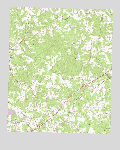
Homer, GA USGS Topographic Map
Click on map above to begin viewing in our Map Viewer.

This topographic map contains these locations and features:
Feature Name Type Latitude Longitude GNIS ID View Map
ArpPopulated PlaceN34.3070°W83.4116°347177View Map
Arp School (historical)SchoolN34.3145°W83.4104°349228View Map
Banks CountyCivilN34.3541°W83.4974°349230View Map
Banks County CourthouseBuildingN34.3337°W83.4991°349231View Map
Banks County Elementary SchoolSchoolN34.3240°W83.4980°349232View Map
Banks County Fire and Emergency Medical Services Station 310BuildingN34.2562°W83.4534°2604664View Map
Banks County Fire and Emergency Medical Services Station 420BuildingN34.3723°W83.4031°2604658View Map
Banks County Fire Station 320BuildingN34.2794°W83.4142°2604018View Map
Banks County High SchoolSchoolN34.3088°W83.4986°349233View Map
Banks County JailBuildingN34.3139°W83.4715°2734101View Map
Banks County Middle SchoolSchoolN34.3125°W83.4783°2545713View Map
Banks County Sheriff's OfficeBuildingN34.3138°W83.4715°2733485View Map
Banks CrossingPopulated PlaceN34.2568°W83.4641°1705264View Map
Beaverdam CemeteryCemeteryN34.2704°W83.4227°349235View Map
Beaverdam ChurchChurchN34.2701°W83.4224°354513View Map
Beaverdam CreekStreamN34.2582°W83.3990°354516View Map
Bethany ChurchChurchN34.3595°W83.4782°354583View Map
Black CreekStreamN34.2690°W83.4693°354744View Map
Black Creek ChurchChurchN34.2621°W83.4829°311476View Map
Black Creek ChurchChurchN34.2618°W83.4832°349237View Map
Bush River ChurchChurchN34.3154°W83.4113°354920View Map
Bush River School (historical)SchoolN34.3118°W83.4368°349241View Map
Bushville School (historical)SchoolN34.2904°W83.4629°349242View Map
CarlanPopulated PlaceN34.3343°W83.4004°326207View Map
Crooked CreekStreamN34.2632°W83.4546°313145View Map
Davis AcademySchoolN34.2807°W83.4177°313329View Map
Exit 53CrossingN34.2548°W83.4632°1704974View Map
Exit 54CrossingN34.2982°W83.4065°1704975View Map
Flat Creek School (historical)SchoolN34.2659°W83.4860°349252View Map
Garrison CreekStreamN34.3504°W83.4749°327922View Map
Grove LevelPopulated PlaceN34.2573°W83.4904°331878View Map
Grove River Structure Number 44 DamDamN34.2534°W83.4399°338728View Map
Grove River Structure Number 51 DamDamN34.2718°W83.4949°338730View Map
Harden LakeReservoirN34.2726°W83.4486°339215View Map
Harden Lake DamDamN34.2718°W83.4482°339214View Map
Hardens BridgeBridgeN34.2632°W83.4466°349261View Map
Hickory Level CreekStreamN34.2771°W83.4929°315369View Map
Holbrook CreekStreamN34.3504°W83.4749°328188View Map
Holland CemeteryCemeteryN34.2607°W83.4874°315540View Map
HomerPopulated PlaceN34.3337°W83.4991°332015View Map
Homer ChurchChurchN34.3259°W83.4979°315601View Map
Homer DivisionCivilN34.3594°W83.4855°1936324View Map
Homer Historic DistrictParkN34.3340°W83.4988°349268View Map
Homer Volunteer Fire DepartmentBuildingN34.3336°W83.4990°2603562View Map
JewelvillePopulated PlaceN34.3720°W83.4038°326343View Map
Martin Bridge (historical)BridgeN34.2937°W83.4054°349273View Map
Mashburn DamDamN34.3168°W83.4499°335995View Map
McDonald CemeteryCemeteryN34.2823°W83.4793°317897View Map
Mount PleasantPopulated PlaceN34.3679°W83.4421°332434View Map
Mount Pleasant ChurchChurchN34.3632°W83.4418°318860View Map
Mount Pleasant School (historical)SchoolN34.3645°W83.4427°349281View Map
Nails Creek CemeteryCemeteryN34.3723°W83.4052°349283View Map
Nails Creek ChurchChurchN34.3723°W83.4060°319193View Map
Nails Creek School (historical)SchoolN34.3573°W83.4054°349284View Map
Neils Grove ChurchChurchN34.2748°W83.3940°319242View Map
New Salem CemeteryCemeteryN34.2829°W83.4168°349286View Map
New Salem ChurchChurchN34.2832°W83.4160°319541View Map
New Salem Covered BridgeBridgeN34.2629°W83.3863°349287View Map
Reservoir 44ReservoirN34.2514°W83.4392°338729View Map
Reservoir 51ReservoirN34.2692°W83.4973°338731View Map
Ridgeway CemeteryCemeteryN34.2579°W83.4902°349291View Map
Ridgeway ChurchChurchN34.2576°W83.4904°321598View Map
Ridgeway School (historical)SchoolN34.2576°W83.4904°349292View Map
Salem School (historical)SchoolN34.2840°W83.4168°349295View Map
Southeast Banks DivisionCivilN34.2678°W83.4110°1936217View Map
Thomas BridgeBridgeN34.2665°W83.4254°349302View Map
Thomas CemeteryCemeteryN34.2679°W83.4235°324076View Map
Town of HomerCivilN34.3350°W83.4987°2405857View Map
Turk LakeReservoirN34.3259°W83.4486°339217View Map
Turk Lake DamDamN34.3251°W83.4482°339216View Map
Webb CreekStreamN34.3104°W83.4488°324958View Map
Webb Creek ChurchChurchN34.3007°W83.4599°324959View Map
Weebs Creek CemeteryCemeteryN34.2998°W83.4607°349304View Map
Wilmot CemeteryCemeteryN34.3709°W83.3943°325418View Map

Note: Coordinates in the location and feature list above are referenced to NAD83 datum.


Copyright (C) 2008-2024 Ryan Niemi / Sunset Dynamics ... All Rights Reserved