TopoQuest Logo
Do you find TopoQuest useful?
Help keep TopoQuest running and adding new maps/features by donating!
Bitcoin:  19c7KJd3qBynnjoSw5npx9KScwjBe4ifkT
Litecoin:  LXs6TkuXGGXo1vDsWCkWVdjQX94eUKd6ui
Home View Maps Find Maps Find Places Resources & Links


Florida, Ohio Topographic Map

USGS Map Title: Florida, OH
USGS Map MRC: 41084C2
DRG (GeoTIFF) Download: o41084c2.tif


Neighboring USGS Topographic Map Quads:


  Ridgeville Corners, OH  
41084D3
 

  Napoleon West, OH  
41084D2
 

  Napoleon East, OH  
41084D1
 

  Defiance East, OH  
41084C3
 

  Florida, OH  
41084C2
 

  Malinta, OH  
41084C1
 

  Ayersville, OH  
41084B3
 

  New Bavaria, OH  
41084B2
 

  Hamler, OH  
41084B1


Map MRC Location:

N42°
W85°
N42°
W84°
H8 H7 H6 H5 H4 H3 H2 H1
G8 G7 G6 G5 G4 G3 G2 G1
F8 F7 F6 F5 F4 F3 F2 F1
E8 E7 E6 E5 E4 E3 E2 E1
D8 D7 D6 D5 D4 D3 D2 D1
C8 C7 C6 C5 C4 C3 C2 C1
B8 B7 B6 B5 B4 B3 B2 B1
A8 A7 A6 A5 A4 A3 A2 A1
N41°
W85°
N41°
W84°

Florida, OH USGS 1:24K Topographic Map Preview:
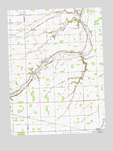
Florida, OH USGS Topographic Map
Click on map above to begin viewing in our Map Viewer.

This topographic map contains these locations and features:
Feature Name Type Latitude Longitude GNIS ID View Map
Barnes CreekStreamN41.3473°W84.2280°1060843View Map
Benien CreekStreamN41.3637°W84.1536°1060862View Map
Bethlehem Evangelical Lutheran ChurchChurchN41.3700°W84.2286°1079937View Map
Brey CemeteryCemeteryN41.3534°W84.1991°1806061View Map
Brinkman CemeteryCemeteryN41.3117°W84.2108°1038323View Map
Brinkman DitchCanalN41.2662°W84.1480°1038324View Map
Brubaker CreekStreamN41.3531°W84.1861°1065940View Map
Christy's AirportAirportN41.3466°W84.1630°1082882View Map
Cole CemeteryCemeteryN41.3264°W84.1522°1039244View Map
FloridaPopulated PlaceN41.3220°W84.2044°1064660View Map
Florida - Flatrock Township Volunteer Fire DepartmentBuildingN41.3230°W84.1991°2549965View Map
Florida CemeteryCemeteryN41.3256°W84.2019°1806062View Map
Florida High School (historical)SchoolN41.3242°W84.2058°1806400View Map
Florida Post Office (historical)Post OfficeN41.3223°W84.2041°1994585View Map
Florida United Methodist ChurchChurchN41.3223°W84.2052°1806401View Map
Girty IslandIslandN41.3289°W84.1538°1061096View Map
Gunn CemeteryCemeteryN41.3306°W84.1516°1041215View Map
Huston CemeteryCemeteryN41.3053°W84.1680°1041900View Map
Huston CreekStreamN41.3045°W84.1555°1041901View Map
Miami and Erie CanalCanalN41.3270°W84.1944°1057843View Map
OkolonaPopulated PlaceN41.3553°W84.2177°1065196View Map
Okolona Post OfficePost OfficeN41.3556°W84.2180°1994576View Map
Parry CemeteryCemeteryN41.3117°W84.2230°1044314View Map
Saint Peter Evangelical Lutheran ChurchChurchN41.2520°W84.1330°1806409View Map
Saint Peters Evangelical Lutheran ChurchChurchN41.3212°W84.2069°1806410View Map
Sand IslandIslandN41.3050°W84.2224°1045933View Map
StandleyPopulated PlaceN41.2675°W84.2274°1065374View Map
Township of FlatrockCivilN41.2971°W84.1710°1086288View Map
Village of FloridaCivilN41.3238°W84.2002°2398887View Map
Wade CreekStreamN41.3270°W84.1536°1047481View Map
WNDH-FM (Napoleon)TowerN41.3000°W84.1561°1085389View Map

Note: Coordinates in the location and feature list above are referenced to NAD83 datum.


Copyright (C) 2008-2024 Ryan Niemi / Sunset Dynamics ... All Rights Reserved