TopoQuest Logo
Do you find TopoQuest useful?
Help keep TopoQuest running and adding new maps/features by donating!
Bitcoin:  19c7KJd3qBynnjoSw5npx9KScwjBe4ifkT
Litecoin:  LXs6TkuXGGXo1vDsWCkWVdjQX94eUKd6ui
Home View Maps Find Maps Find Places Resources & Links


Ridgeville Corners, Ohio Topographic Map

USGS Map Title: Ridgeville Corners, OH
USGS Map MRC: 41084D3
DRG (GeoTIFF) Download: o41084d3.tif


Neighboring USGS Topographic Map Quads:


  West Unity, OH  
41084E4
 

  Archbold, OH  
41084E3
 

  Wauseon, OH  
41084E2
 

  Evansport, OH  
41084D4
 

  Ridgeville Corners, OH  
41084D3
 

  Napoleon West, OH  
41084D2
 

  Defiance West, OH  
41084C4
 

  Defiance East, OH  
41084C3
 

  Florida, OH  
41084C2


Map MRC Location:

N42°
W85°
N42°
W84°
H8 H7 H6 H5 H4 H3 H2 H1
G8 G7 G6 G5 G4 G3 G2 G1
F8 F7 F6 F5 F4 F3 F2 F1
E8 E7 E6 E5 E4 E3 E2 E1
D8 D7 D6 D5 D4 D3 D2 D1
C8 C7 C6 C5 C4 C3 C2 C1
B8 B7 B6 B5 B4 B3 B2 B1
A8 A7 A6 A5 A4 A3 A2 A1
N41°
W85°
N41°
W84°

Ridgeville Corners, OH USGS 1:24K Topographic Map Preview:
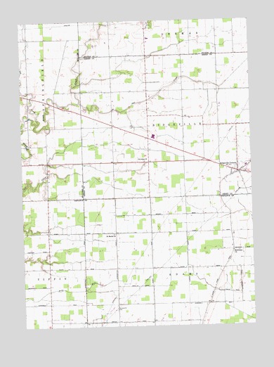
Ridgeville Corners, OH USGS Topographic Map
Click on map above to begin viewing in our Map Viewer.

This topographic map contains these locations and features:
Feature Name Type Latitude Longitude GNIS ID View Map
Adams RidgePopulated PlaceN41.3987°W84.2655°1057287View Map
Adams Ridge Post Office (historical)Post OfficeN41.3987°W84.2652°1983545View Map
Archbold Middle SchoolSchoolN41.4403°W84.2527°1050141View Map
Bethlehem Lutheran CemeteryCemeteryN41.4048°W84.2608°1806046View Map
Bethlehem Lutheran ChurchChurchN41.4053°W84.2608°1056714View Map
Buehrer FarmsLocaleN41.4447°W84.3492°2677550View Map
Corrections Center of Northwest OhioBuildingN41.4590°W84.3581°2722723View Map
Domersville CemeteryCemeteryN41.3823°W84.3244°1039746View Map
Domerville (historical)Populated PlaceN41.3842°W84.3241°1063299View Map
Domerville Post Office (historical)Post OfficeN41.3848°W84.3236°1983561View Map
Four County Joint Vocational SchoolSchoolN41.4531°W84.3049°1050138View Map
Fox ChasePopulated PlaceN41.4942°W84.3117°2678145View Map
Hickory HillsPopulated PlaceN41.4689°W84.3730°1055248View Map
Locust CemeteryCemeteryN41.4389°W84.2606°1806064View Map
Northwest Technical CollegeSchoolN41.4528°W84.3030°1050139View Map
Owl CreekStreamN41.4576°W84.3666°1044253View Map
Owl CreekStreamN41.4667°W84.3433°1044257View Map
Plants Plus NurseryBuildingN41.4828°W84.3067°2651836View Map
Ridgeville CornersPopulated PlaceN41.4378°W84.2574°1061605View Map
Ridgeville Corners Census Designated PlaceCensusN41.4388°W84.2554°2628960View Map
Ridgeville Corners Post OfficePost OfficeN41.4376°W84.2574°1994577View Map
Ridgeville Township Volunteer Fire DepartmentBuildingN41.4382°W84.2596°2549960View Map
Roselawn FarmLocaleN41.4597°W84.3444°2677551View Map
Saint John Lutheran ChurchChurchN41.4425°W84.3081°2677565View Map
Saint Johns CemeteryCemeteryN41.4426°W84.3086°1806067View Map
Saint Johns ChurchChurchN41.4423°W84.3091°1045539View Map
Saint Mark's Lutheran ChurchChurchN41.4128°W84.3258°1056935View Map
Saint Marks Lutheran CemeteryCemeteryN41.4128°W84.3258°1806059View Map
Saint Peter CemeteryCemeteryN41.4389°W84.2549°1050140View Map
Saint Peter ChurchChurchN41.4367°W84.2519°1050143View Map
Township of AdamsCivilN41.3840°W84.2847°1086029View Map
Township of RidgevilleCivilN41.4567°W84.2852°1086297View Map
Zion CemeteryCemeteryN41.4417°W84.3627°1048261View Map
Zion ChurchChurchN41.4398°W84.2519°1050142View Map

Note: Coordinates in the location and feature list above are referenced to NAD83 datum.


Copyright (C) 2008-2024 Ryan Niemi / Sunset Dynamics ... All Rights Reserved