TopoQuest Logo
Do you find TopoQuest useful?
Help keep TopoQuest running and adding new maps/features by donating!
Bitcoin:  19c7KJd3qBynnjoSw5npx9KScwjBe4ifkT
Litecoin:  LXs6TkuXGGXo1vDsWCkWVdjQX94eUKd6ui
Home View Maps Find Maps Find Places Resources & Links


Ayersville, Ohio Topographic Map

USGS Map Title: Ayersville, OH
USGS Map MRC: 41084B3
DRG (GeoTIFF) Download: o41084b3.tif


Neighboring USGS Topographic Map Quads:


  Defiance West, OH  
41084C4
 

  Defiance East, OH  
41084C3
 

  Florida, OH  
41084C2
 

  Junction, OH  
41084B4
 

  Ayersville, OH  
41084B3
 

  New Bavaria, OH  
41084B2
 

  Oakwood, OH  
41084A4
 

  Continental, OH  
41084A3
 

  Miller City, OH  
41084A2


Map MRC Location:

N42°
W85°
N42°
W84°
H8 H7 H6 H5 H4 H3 H2 H1
G8 G7 G6 G5 G4 G3 G2 G1
F8 F7 F6 F5 F4 F3 F2 F1
E8 E7 E6 E5 E4 E3 E2 E1
D8 D7 D6 D5 D4 D3 D2 D1
C8 C7 C6 C5 C4 C3 C2 C1
B8 B7 B6 B5 B4 B3 B2 B1
A8 A7 A6 A5 A4 A3 A2 A1
N41°
W85°
N41°
W84°

Ayersville, OH USGS 1:24K Topographic Map Preview:
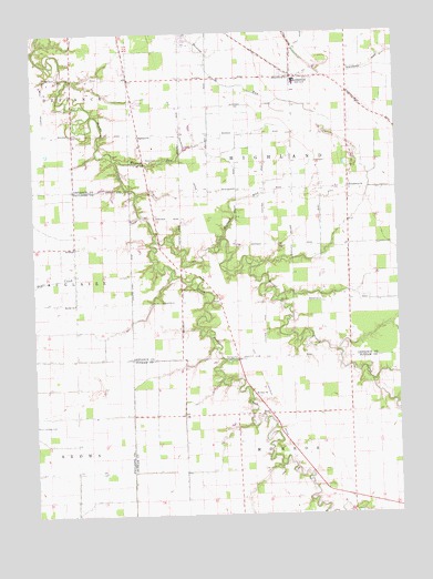
Ayersville, OH USGS Topographic Map
Click on map above to begin viewing in our Map Viewer.

This topographic map contains these locations and features:
Feature Name Type Latitude Longitude GNIS ID View Map
Andrews FarmsLocaleN41.1619°W84.3561°2567331View Map
ArthurPopulated PlaceN41.1948°W84.3608°1037493View Map
Arthur Post Office (historical)Post OfficeN41.1945°W84.3611°2041912View Map
AyersvillePopulated PlaceN41.2387°W84.2855°1064368View Map
Ayersville Elementary SchoolSchoolN41.2367°W84.2847°1055108View Map
Ayersville High SchoolSchoolN41.2375°W84.2847°1055109View Map
Ayersville Post Office (historical)Post OfficeN41.2389°W84.2861°1983556View Map
Ayersville United Methodist ChurchChurchN41.2384°W84.2827°1079629View Map
Bauer Landing Strip (historical)AirportN41.1489°W84.3741°1077515View Map
Beulah ChurchChurchN41.1798°W84.3608°1037977View Map
Blevins AirportAirportN41.2079°W84.2701°1082477View Map
Countryside EstatesPopulated PlaceN41.2453°W84.3147°2680203View Map
Don Mar FarmsLocaleN41.1758°W84.3106°2567343View Map
Evangelical ChurchChurchN41.2098°W84.2661°1040252View Map
Highland Church (historical)ChurchN41.2234°W84.3386°1079952View Map
Highland Township Volunteer Fire Department Station 100BuildingN41.2388°W84.2908°2549726View Map
Hill CemeteryCemeteryN41.2242°W84.2744°1041579View Map
Hogback RunStreamN41.1934°W84.3113°1041656View Map
Ice CemeteryCemeteryN41.1873°W84.3424°1961015View Map
Mansfield CemeteryCemeteryN41.1834°W84.3238°1042927View Map
Mount Zion CemeteryCemeteryN41.1556°W84.2999°1071350View Map
Mount Zion ChurchChurchN41.1562°W84.2997°1043669View Map
Myers CemeteryCemeteryN41.2170°W84.3352°1043757View Map
North Powell CreekStreamN41.1962°W84.3336°1043908View Map
RicePopulated PlaceN41.1509°W84.2944°1061598View Map
Rice Post Office (historical)Post OfficeN41.1514°W84.2944°2056202View Map
South Powell CreekStreamN41.1962°W84.3333°1058033View Map
SouthertonPopulated PlaceN41.1800°W84.3111°1065478View Map
Steffel DitchCanalN41.1728°W84.3658°1961065View Map
Taylor CemeteryCemeteryN41.2309°W84.3630°1046965View Map
Township of HighlandCivilN41.2096°W84.2848°1086034View Map
Trimed Emergency Medical ServicesBuildingN41.2217°W84.3244°2550951View Map
Wagner RunStreamN41.2170°W84.3463°1047486View Map

Note: Coordinates in the location and feature list above are referenced to NAD83 datum.


Copyright (C) 2008-2024 Ryan Niemi / Sunset Dynamics ... All Rights Reserved