TopoQuest Logo
Do you find TopoQuest useful?
Help keep TopoQuest running and adding new maps/features by donating!
Bitcoin:  19c7KJd3qBynnjoSw5npx9KScwjBe4ifkT
Litecoin:  LXs6TkuXGGXo1vDsWCkWVdjQX94eUKd6ui
Home View Maps Find Maps Find Places Resources & Links


Conrad, Pennsylvania Topographic Map

USGS Map Title: Conrad, PA
USGS Map MRC: 41077E8
DRG (GeoTIFF) Download: o41077e8.tif


Neighboring USGS Topographic Map Quads:


  Austin, PA  
41078F1
 

  Ayers Hill, PA  
41077F8
 

  Cherry Springs, PA  
41077F7
 

  Wharton, PA  
41078E1
 

  Conrad, PA  
41077E8
 

  Short Run, PA  
41077E7
 

  First Fork, PA  
41078D1
 

  Hammersley Fork, PA  
41077D8
 

  Tamarack, PA  
41077D7


Map MRC Location:

N42°
W78°
N42°
W77°
H8 H7 H6 H5 H4 H3 H2 H1
G8 G7 G6 G5 G4 G3 G2 G1
F8 F7 F6 F5 F4 F3 F2 F1
E8 E7 E6 E5 E4 E3 E2 E1
D8 D7 D6 D5 D4 D3 D2 D1
C8 C7 C6 C5 C4 C3 C2 C1
B8 B7 B6 B5 B4 B3 B2 B1
A8 A7 A6 A5 A4 A3 A2 A1
N41°
W78°
N41°
W77°

Conrad, PA USGS 1:24K Topographic Map Preview:
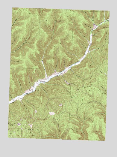
Conrad, PA USGS Topographic Map
Click on map above to begin viewing in our Map Viewer.

This topographic map contains these locations and features:
Feature Name Type Latitude Longitude GNIS ID View Map
Birch RunStreamN41.5576°W77.9494°1192147View Map
Black Stump HollowValleyN41.5430°W77.9820°1169739View Map
Brooks CemeteryCemeteryN41.5460°W77.9738°1170331View Map
Bunnell RidgeRidgeN41.5473°W77.8828°1170689View Map
Bunnell Ridge TrailTrailN41.5523°W77.8947°1170690View Map
Camp RunStreamN41.5770°W77.9078°1171081View Map
ConradPopulated PlaceN41.6101°W77.8906°1172362View Map
Cow Run TrailTrailN41.5195°W77.8936°1172546View Map
Darling RunStreamN41.5378°W77.8911°1172953View Map
Darling Run TrailTrailN41.5315°W77.9081°1172955View Map
Dry RunStreamN41.5895°W77.8861°1173549View Map
Five PointsPopulated PlaceN41.5087°W77.9689°1203592View Map
Five Points HelistopAirportN41.5167°W77.9706°1194248View Map
Gravel Lick RunStreamN41.5695°W77.9228°1176003View Map
Gravel Lick TrailTrailN41.5584°W77.9033°1176006View Map
Graveyard HollowValleyN41.6013°W77.8962°1176017View Map
HammersleyPopulated PlaceN41.5509°W77.9672°1198007View Map
Hi Foster HollowValleyN41.5850°W77.8987°1176931View Map
Horton RunStreamN41.6167°W77.8753°1192636View Map
Hunter HollowValleyN41.5364°W77.9944°1177609View Map
Jackson Lick RunStreamN41.6056°W77.8956°1177922View Map
JamisonPopulated PlaceN41.5867°W77.8947°1198006View Map
Jamison RunStreamN41.5865°W77.9003°1177987View Map
Jordan HollowValleyN41.5518°W77.9625°1178166View Map
Little Joe RunStreamN41.5859°W77.9031°1179571View Map
LoguePopulated PlaceN41.5590°W77.9500°1204051View Map
Long HollowValleyN41.5535°W77.9555°1179856View Map
Long Hollow TrailTrailN41.5476°W77.9261°1179859View Map
Lower Vag HollowValleyN41.5373°W77.9847°1180039View Map
Marvin RunStreamN41.5626°W77.9361°1180512View Map
McConnell HollowValleyN41.5024°W77.9352°1180651View Map
McDonald HollowValleyN41.5010°W77.9313°1180688View Map
McDonald Hollow TrailTrailN41.5078°W77.9131°1180689View Map
McFall CemeteryCemeteryN41.6005°W77.8967°1180710View Map
Mud Lick RunStreamN41.5673°W77.9283°1182008View Map
Nelson HollowValleyN41.5276°W77.9262°1182239View Map
Nelson Hollow TrailTrailN41.5237°W77.9167°1182241View Map
Pine Hill RunStreamN41.5937°W77.8767°1183840View Map
Road BranchStreamN41.6156°W77.8958°1192050View Map
Schoolhouse RunStreamN41.5495°W77.9689°1187117View Map
Shang HollowValleyN41.5180°W77.9034°1187350View Map
Shang Hollow TrailTrailN41.5362°W77.9050°1187351View Map
Stony Lick RunStreamN41.6145°W77.8797°1188778View Map
Stony RunStreamN41.5934°W77.8961°1188800View Map
Stony TrailTrailN41.6070°W77.9164°1188810View Map
Township of WhartonCivilN41.5416°W77.9400°1216990View Map
Upper Vag HollowValleyN41.5385°W77.9823°1190262View Map
Wild Boy RunStreamN41.6095°W77.8892°1191393View Map
Williams RunStreamN41.5628°W77.9372°1191472View Map

Note: Coordinates in the location and feature list above are referenced to NAD83 datum.


Copyright (C) 2008-2024 Ryan Niemi / Sunset Dynamics ... All Rights Reserved