TopoQuest Logo
Do you find TopoQuest useful?
Help keep TopoQuest running and adding new maps/features by donating!
Bitcoin:  19c7KJd3qBynnjoSw5npx9KScwjBe4ifkT
Litecoin:  LXs6TkuXGGXo1vDsWCkWVdjQX94eUKd6ui
Home View Maps Find Maps Find Places Resources & Links


Concord, Illinois Topographic Map

USGS Map Title: Concord, IL
USGS Map MRC: 39090G3
DRG (GeoTIFF) Download: o39090g3.tif


Neighboring USGS Topographic Map Quads:


  Arenzville West, IL  
39090H4
 

  Arenzville East, IL  
39090H3
 

  Virginia, IL  
39090H2
 

  Chapin, IL  
39090G4
 

  Concord, IL  
39090G3
 

  Literberry, IL  
39090G2
 

  Winchester, IL  
39090F4
 

  Lynnville, IL  
39090F3
 

  Jacksonville, IL  
39090F2


Map MRC Location:

N40°
W91°
N40°
W90°
H8 H7 H6 H5 H4 H3 H2 H1
G8 G7 G6 G5 G4 G3 G2 G1
F8 F7 F6 F5 F4 F3 F2 F1
E8 E7 E6 E5 E4 E3 E2 E1
D8 D7 D6 D5 D4 D3 D2 D1
C8 C7 C6 C5 C4 C3 C2 C1
B8 B7 B6 B5 B4 B3 B2 B1
A8 A7 A6 A5 A4 A3 A2 A1
N39°
W91°
N39°
W90°

Concord, IL USGS 1:24K Topographic Map Preview:
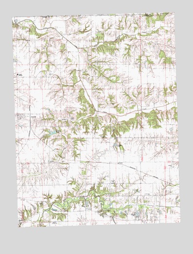
Concord, IL USGS Topographic Map
Click on map above to begin viewing in our Map Viewer.

This topographic map contains these locations and features:
Feature Name Type Latitude Longitude GNIS ID View Map
Angel CemeteryCemeteryN39.8307°W90.3142°1720906View Map
Applebee PondReservoirN39.7648°W90.2526°1691713View Map
Applebee Pond DamDamN39.7650°W90.2518°1691712View Map
Arcadia Election PrecinctCivilN39.8110°W90.2676°1928437View Map
Caldwell CemeteryCemeteryN39.7752°W90.3010°1720911View Map
Chapin CemeteryCemeteryN39.7642°W90.3554°1720912View Map
ConcordPopulated PlaceN39.8167°W90.3729°406437View Map
Concord Christian ChurchChurchN39.8148°W90.3707°2041811View Map
Concord Election PrecinctCivilN39.8341°W90.3710°1928467View Map
Concord Post OfficePost OfficeN39.8168°W90.3729°2788701View Map
Concord ReservoirReservoirN39.8057°W90.3467°406450View Map
Concord Reservoir DamDamN39.8064°W90.3437°1691840View Map
Concord United Methodist ChurchChurchN39.8167°W90.3696°2041812View Map
Concord Volunteer Fire DepartmentBuildingN39.8161°W90.3725°2640926View Map
Crum CemeteryCemeteryN39.8734°W90.2818°1822101View Map
Duncan SpringSpringN39.8137°W90.3327°1720916View Map
Duncan Springs School (historical)SchoolN39.8095°W90.3312°407488View Map
Ebenezer CemeteryCemeteryN39.7856°W90.2551°1822102View Map
Ebenezer ChurchChurchN39.7845°W90.2543°407741View Map
Ebenezer School (historical)SchoolN39.7942°W90.2535°407747View Map
Grace Chapel (historical)ChurchN39.8223°W90.2885°409225View Map
Harmony School (historical)SchoolN39.7878°W90.3698°409814View Map
Jersey College School (historical)SchoolN39.8339°W90.2771°411102View Map
Joy PrairiePopulated PlaceN39.7867°W90.2982°422853View Map
Kinnan School (historical)SchoolN39.7550°W90.2665°411527View Map
Leland LakeReservoirN39.7559°W90.2832°1720930View Map
Lick BranchStreamN39.8195°W90.3129°412045View Map
Little Indian CreekStreamN39.8553°W90.3254°412359View Map
Morgan County Farm CemeteryCemeteryN39.7671°W90.2729°1720913View Map
Morgan County Poor Farm CemeteryCemeteryN39.7700°W90.2821°1720914View Map
Mount Vernon CemeteryCemeteryN39.8403°W90.3482°1720933View Map
Mount Vernon School (historical)SchoolN39.8395°W90.3415°414099View Map
Mount Zion ChurchChurchN39.7612°W90.3223°1720934View Map
Mount Zion Lutheran CemeteryCemeteryN39.7612°W90.3218°1822123View Map
North Union School (historical)SchoolN39.7742°W90.2882°414684View Map
Pleasant Grove SchoolSchoolN39.8537°W90.3729°415809View Map
Roegge LakeReservoirN39.7971°W90.2988°1720941View Map
Smith CemeteryCemeteryN39.8214°W90.2982°1720947View Map
Sugar HollowValleyN39.8120°W90.2959°419316View Map
Sunnyside School (historical)SchoolN39.7748°W90.3471°419394View Map
Triopia Junior-Senior High SchoolSchoolN39.8409°W90.3718°1720951View Map
Union School (historical)SchoolN39.8748°W90.2760°420111View Map
Village of ConcordCivilN39.8160°W90.3709°2398611View Map
Walnut Grove CemeteryCemeteryN39.8014°W90.3076°1720953View Map
Walnut Grove School (historical)SchoolN39.8006°W90.3021°420468View Map
Werries Airport (historical)AirportN39.8067°W90.3665°427185View Map
Whiteoak Grove School (historical)SchoolN39.8389°W90.3004°421094View Map
Williams AirparkAirportN39.7506°W90.3501°427133View Map
Wood CemeteryCemeteryN39.7591°W90.3058°1720956View Map
Woodward CemeteryCemeteryN39.7878°W90.3493°1720957View Map

Note: Coordinates in the location and feature list above are referenced to NAD83 datum.


Copyright (C) 2008-2024 Ryan Niemi / Sunset Dynamics ... All Rights Reserved