TopoQuest Logo
Do you find TopoQuest useful?
Help keep TopoQuest running and adding new maps/features by donating!
Bitcoin:  19c7KJd3qBynnjoSw5npx9KScwjBe4ifkT
Litecoin:  LXs6TkuXGGXo1vDsWCkWVdjQX94eUKd6ui
Home View Maps Find Maps Find Places Resources & Links


Colliers, South Carolina Topographic Map

USGS Map Title: Colliers, SC
USGS Map MRC: 33082F1
DRG (GeoTIFF) Download: o33082f1.tif


Neighboring USGS Topographic Map Quads:


  Parksville, SC  
33082G2
 

  Red Hill, SC  
33082G1
 

  Edgefield, SC  
33081G8
 

  Clarks Hill, SC  
33082F2
 

  Colliers, SC  
33082F1
 

  Ropers Crossroads, SC  
33081F8
 

  Evans, GA  
33082E2
 

  Martinez, GA  
33082E1
 

  North Augusta, SC  
33081E8


Map MRC Location:

N34°
W83°
N34°
W82°
H8 H7 H6 H5 H4 H3 H2 H1
G8 G7 G6 G5 G4 G3 G2 G1
F8 F7 F6 F5 F4 F3 F2 F1
E8 E7 E6 E5 E4 E3 E2 E1
D8 D7 D6 D5 D4 D3 D2 D1
C8 C7 C6 C5 C4 C3 C2 C1
B8 B7 B6 B5 B4 B3 B2 B1
A8 A7 A6 A5 A4 A3 A2 A1
N33°
W83°
N33°
W82°

Colliers, SC USGS 1:24K Topographic Map Preview:
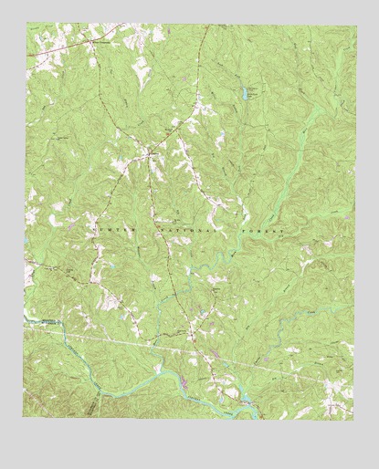
Colliers, SC USGS Topographic Map
Click on map above to begin viewing in our Map Viewer.

This topographic map contains these locations and features:
Feature Name Type Latitude Longitude GNIS ID View Map
Big BranchStreamN33.6993°W82.0460°1229411View Map
Big BranchStreamN33.6360°W82.0385°1229415View Map
Big CreekStreamN33.6729°W82.0612°1229416View Map
Briggs Quarter School (historical)SchoolN33.6346°W82.0196°1228928View Map
Carey HillSummitN33.6712°W82.1093°1247160View Map
Carey Hill ChurchChurchN33.6724°W82.1137°1247162View Map
Carey Hill School (historical)SchoolN33.6676°W82.0998°1228922View Map
Cedar Branch School (historical)SchoolN33.7493°W82.0462°1228927View Map
Cedar Branch School (historical)SchoolN33.6637°W82.0440°1240534View Map
Cedar CreekStreamN33.7251°W82.0071°1229531View Map
Cheves CreekStreamN33.6324°W82.0412°1247281View Map
ColliersPopulated PlaceN33.7087°W82.0776°1229577View Map
Colliers ChurchChurchN33.7076°W82.0776°1228924View Map
Colliers School (historical)SchoolN33.7085°W82.0771°1228925View Map
Dry BranchStreamN33.6365°W82.0426°1229653View Map
Dry CreekStreamN33.6832°W82.0357°1229656View Map
Horn CreekStreamN33.6399°W82.1229°1229818View Map
Horn Creek Hiking TrailTrailN33.7096°W82.0226°1252012View Map
Lick ForkStreamN33.6837°W82.0432°1229904View Map
Lick Fork CampgroundLocaleN33.7285°W82.0401°1230595View Map
Lick Fork LakeReservoirN33.7283°W82.0420°1229905View Map
Lick Fork Lake Dam D-0875DamN33.7262°W82.0410°1238879View Map
Martin CemeteryCemeteryN33.7490°W82.0484°1229972View Map
McKie CemeteryCemeteryN33.6598°W82.0871°1229991View Map
Miller BranchStreamN33.7171°W82.0426°1230016View Map
Millers CrossroadsPopulated PlaceN33.7443°W82.1010°1246676View Map
Mount Olive ChurchChurchN33.7171°W82.0693°1230059View Map
Mount Olive Church (historical)ChurchN33.7162°W82.0032°1228929View Map
Mount Olive School (historical)SchoolN33.7171°W82.0690°1228926View Map
Mount Zion ChurchChurchN33.6874°W82.0687°1230068View Map
Owl BranchStreamN33.7168°W82.0868°1230136View Map
Pine Grove School (historical)SchoolN33.6521°W82.0662°1228923View Map
Piney Grove ChurchChurchN33.6524°W82.0668°1230173View Map
Poplar Spring ChurchChurchN33.7135°W82.1132°1250216View Map
Prescott CemeteryCemeteryN33.7485°W82.1037°1230197View Map
Reedy BranchStreamN33.6257°W82.0457°1230228View Map
Republican ChurchChurchN33.6660°W82.0537°1230236View Map
Rock CreekStreamN33.7201°W82.0171°1230241View Map
Southeast Edgefield DivisionCivilN33.6309°W82.0011°1938430View Map
Wall Pond Dam D-1691DamN33.6851°W82.1082°1238877View Map
Williams BranchStreamN33.6612°W82.0740°1230501View Map

Note: Coordinates in the location and feature list above are referenced to NAD83 datum.


Copyright (C) 2008-2024 Ryan Niemi / Sunset Dynamics ... All Rights Reserved