TopoQuest Logo
Do you find TopoQuest useful?
Help keep TopoQuest running and adding new maps/features by donating!
Bitcoin:  19c7KJd3qBynnjoSw5npx9KScwjBe4ifkT
Litecoin:  LXs6TkuXGGXo1vDsWCkWVdjQX94eUKd6ui
Home View Maps Find Maps Find Places Resources & Links


Parksville, South Carolina Topographic Map

USGS Map Title: Parksville, SC
USGS Map MRC: 33082G2
DRG (GeoTIFF) Download: o33082g2.tif


Neighboring USGS Topographic Map Quads:


  McCormick, SC  
33082H3
 

  Winterseat, SC  
33082H2
 

  Limestone, SC  
33082H1
 

  Plum Branch, SC  
33082G3
 

  Parksville, SC  
33082G2
 

  Red Hill, SC  
33082G1
 

  Leah, GA  
33082F3
 

  Clarks Hill, SC  
33082F2
 

  Colliers, SC  
33082F1


Map MRC Location:

N34°
W83°
N34°
W82°
H8 H7 H6 H5 H4 H3 H2 H1
G8 G7 G6 G5 G4 G3 G2 G1
F8 F7 F6 F5 F4 F3 F2 F1
E8 E7 E6 E5 E4 E3 E2 E1
D8 D7 D6 D5 D4 D3 D2 D1
C8 C7 C6 C5 C4 C3 C2 C1
B8 B7 B6 B5 B4 B3 B2 B1
A8 A7 A6 A5 A4 A3 A2 A1
N33°
W83°
N33°
W82°

Parksville, SC USGS 1:24K Topographic Map Preview:
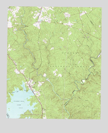
Parksville, SC USGS Topographic Map
Click on map above to begin viewing in our Map Viewer.

This topographic map contains these locations and features:
Feature Name Type Latitude Longitude GNIS ID View Map
Beaverdam CreekStreamN33.8015°W82.1387°1229388View Map
Bethany (historical)Populated PlaceN33.8496°W82.1507°1241317View Map
Blue BranchStreamN33.7760°W82.1607°1229432View Map
Busseys Ferry (historical)CrossingN33.7543°W82.2490°1251644View Map
Busseys Ferry (historical)CrossingN33.7543°W82.2490°335571View Map
Byrd CreekStreamN33.7962°W82.1976°1247078View Map
Byrd Creek Rifle RangeLocaleN33.8573°W82.1846°1252007View Map
Callihams Mill Church (historical)ChurchN33.7857°W82.2176°1229186View Map
Cedar Springs ChurchChurchN33.8104°W82.1579°1247222View Map
Cedar Springs School (historical)SchoolN33.7946°W82.1762°1229187View Map
Church BranchStreamN33.8332°W82.1371°1229556View Map
Coon CreekStreamN33.7926°W82.1590°1229587View Map
Goff BranchStreamN33.8190°W82.1298°1229738View Map
Hamilton Branch CampgroundLocaleN33.7796°W82.2226°1230567View Map
Hamilton Branch State ParkParkN33.7540°W82.2179°1229202View Map
Key BridgeBridgeN33.7949°W82.1443°1246240View Map
Key Bridge Hunt CampLocaleN33.8171°W82.1510°1252009View Map
Mack BranchStreamN33.8274°W82.1393°1229967View Map
Mims School Number 2SchoolN33.7596°W82.2004°1246688View Map
Mount Lebanon ChurchChurchN33.7804°W82.2073°1249594View Map
Mount Lebanon School (historical)SchoolN33.7807°W82.2073°1252054View Map
Mount Moriah ChurchChurchN33.8418°W82.1423°1249602View Map
Mount Moriah School (historical)SchoolN33.8496°W82.1410°1229239View Map
New Hope CemeteryCemeteryN33.8743°W82.2490°1230094View Map
Old Rohoboth CemeteryCemeteryN33.8418°W82.1468°1229312View Map
Parks MillPopulated PlaceN33.8532°W82.2262°1230146View Map
ParksvillePopulated PlaceN33.7862°W82.2196°1230147View Map
Parksville Baptist ChurchChurchN33.7857°W82.2176°1229249View Map
Parksville CemeteryCemeteryN33.7882°W82.2190°1229248View Map
Parksville DivisionCivilN33.7535°W82.2011°1938378View Map
Parksville Methodist ChurchChurchN33.7882°W82.2193°1229251View Map
Parksville Recreation AreaParkN33.7940°W82.2451°1229252View Map
Parksville Volunteer Fire DepartmentBuildingN33.7861°W82.2189°2578313View Map
Parksville Wayside ParkParkN33.7810°W82.2229°1229253View Map
Prices MillLocaleN33.7932°W82.1957°1229263View Map
Rehoboth ChurchChurchN33.8415°W82.1465°1250338View Map
Ritchentown School (historical)SchoolN33.8576°W82.1943°1229211View Map
Rock CreekStreamN33.7826°W82.1532°1250413View Map
Rock Grove School (historical)SchoolN33.7504°W82.2015°1229268View Map
Rohoboth CemeteryCemeteryN33.8412°W82.1468°1229271View Map
Town of ParksvilleCivilN33.7866°W82.2174°2407073View Map
Turkey CreekStreamN33.7718°W82.1662°1230426View Map
Turkey Creek Hiking TrailTrailN33.7990°W82.1418°1252008View Map
Upper Price Mill (historical)LocaleN33.8057°W82.2085°1252059View Map
WhitetownPopulated PlaceN33.8582°W82.2093°1230493View Map
Whitetown School (historical)SchoolN33.8587°W82.2065°1229279View Map
Wine CreekStreamN33.8190°W82.1385°1230513View Map

Note: Coordinates in the location and feature list above are referenced to NAD83 datum.


Copyright (C) 2008-2024 Ryan Niemi / Sunset Dynamics ... All Rights Reserved