TopoQuest Logo
Do you find TopoQuest useful?
Help keep TopoQuest running and adding new maps/features by donating!
Bitcoin:  19c7KJd3qBynnjoSw5npx9KScwjBe4ifkT
Litecoin:  LXs6TkuXGGXo1vDsWCkWVdjQX94eUKd6ui
Home View Maps Find Maps Find Places Resources & Links


Chester, California Topographic Map

USGS Map Title: Chester, CA
USGS Map MRC: 40121C2
DRG (GeoTIFF) Download: o40121c2.tif


Neighboring USGS Topographic Map Quads:


  Mount Harkness, CA  
40121D3
 

  Red Cinder, CA  
40121D2
 

  Swain Mountain, CA  
40121D1
 

  Stover Mountain, CA  
40121C3
 

  Chester, CA  
40121C2
 

  Westwood West, CA  
40121C1
 

  Humbug Valley, CA  
40121B3
 

  Almanor, CA  
40121B2
 

  Canyondam, CA  
40121B1


Map MRC Location:

N41°
W122°
N41°
W121°
H8 H7 H6 H5 H4 H3 H2 H1
G8 G7 G6 G5 G4 G3 G2 G1
F8 F7 F6 F5 F4 F3 F2 F1
E8 E7 E6 E5 E4 E3 E2 E1
D8 D7 D6 D5 D4 D3 D2 D1
C8 C7 C6 C5 C4 C3 C2 C1
B8 B7 B6 B5 B4 B3 B2 B1
A8 A7 A6 A5 A4 A3 A2 A1
N40°
W122°
N40°
W121°

Chester, CA USGS 1:24K Topographic Map Preview:
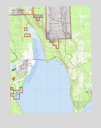
Chester, CA USGS Topographic Map
Click on map above to begin viewing in our Map Viewer.

This topographic map contains these locations and features:
Feature Name Type Latitude Longitude GNIS ID View Map
Almanor Ranger StationLocaleN40.2904°W121.2455°256196View Map
Bailey CreekStreamN40.2863°W121.1586°256430View Map
Benner CreekStreamN40.3249°W121.2086°256827View Map
Catfish BeachBeachN40.3113°W121.1766°258074View Map
ChesterPopulated PlaceN40.3063°W121.2319°277487View Map
Chester Census Designated PlaceCensusN40.3017°W121.2339°2408021View Map
Chester DivisionCivilN40.2724°W121.2357°1935050View Map
Chester Elementary SchoolSchoolN40.3057°W121.2305°1701341View Map
Chester Fire DepartmentBuildingN40.2908°W121.2407°2621805View Map
Chester Fire Protection DistrictBuildingN40.3115°W121.2278°2621799View Map
Chester Junior-Senior High SchoolSchoolN40.3024°W121.2302°1701342View Map
Chester ParkParkN40.3104°W121.2297°1701343View Map
Chester Post OfficePost OfficeN40.3091°W121.2283°1701344View Map
Chester Post Office (historical)Post OfficeN40.3063°W121.2319°2026852View Map
Chester-US Forest Service HeliportAirportN40.2882°W121.2441°1653331View Map
Community United Methodist ChurchChurchN40.3035°W121.2350°1701346View Map
FoxwoodPopulated PlaceN40.2908°W121.1297°2413627View Map
Gould SwampSwampN40.3029°W121.1833°260723View Map
Johnson CreekStreamN40.3221°W121.2072°261970View Map
Johnson FieldsFlatN40.3116°W121.2197°261977View Map
Lake Almanor Country ClubPopulated PlaceN40.2508°W121.1458°2413635View Map
Lake Almanor Country Club Census Designated PlaceCensusN40.2578°W121.1470°2408529View Map
Lake Almanor PeninsulaPopulated PlaceN40.2533°W121.1498°2413636View Map
Lake Almanor Peninsula Census Designated PlaceCensusN40.2812°W121.1345°2408530View Map
Last Chance CampgroundLocaleN40.3538°W121.2241°262328View Map
Last Chance CreekStreamN40.3366°W121.2086°262332View Map
Manzanita MountainSummitN40.3335°W121.1755°1666185View Map
Mud CreekStreamN40.3354°W121.2064°263924View Map
Mud Creek ButteSummitN40.3729°W121.2139°1656183View Map
Mud Creek RimCliffN40.3604°W121.2219°263926View Map
Our Savior Lutheran ChurchChurchN40.3066°W121.2305°1701383View Map
Peninsula Fire Protection District Station 1BuildingN40.2700°W121.1276°2622091View Map
Peninsula VillagePopulated PlaceN40.2732°W121.1305°1656214View Map
Plumas County Sheriff's Office Chester SubstationBuildingN40.3096°W121.2278°2751051View Map
Rogers FieldAirportN40.2902°W121.2399°276233View Map
Seneca Healthcare District HospitalHospitalN40.3058°W121.2347°1701409View Map
Wesleyan ChurchChurchN40.3110°W121.2264°1701418View Map

Note: Coordinates in the location and feature list above are referenced to NAD83 datum.


Copyright (C) 2008-2024 Ryan Niemi / Sunset Dynamics ... All Rights Reserved