TopoQuest Logo
Do you find TopoQuest useful?
Help keep TopoQuest running and adding new maps/features by donating!
Bitcoin:  19c7KJd3qBynnjoSw5npx9KScwjBe4ifkT
Litecoin:  LXs6TkuXGGXo1vDsWCkWVdjQX94eUKd6ui
Home View Maps Find Maps Find Places Resources & Links


Cherry Lake, Florida Topographic Map

USGS Map Title: Cherry Lake, FL
USGS Map MRC: 30083E4
DRG (GeoTIFF) Download: o30083e4.tif


Neighboring USGS Topographic Map Quads:


  Baden, GA  
30083F5
 

  Nankin, GA  
30083F4
 

  Clyattville, GA  
30083F3
 

  Hamburg, FL  
30083E5
 

  Cherry Lake, FL  
30083E4
 

  Pinetta, FL  
30083E3
 

  Greenville NE, FL  
30083D5
 

  Madison, FL  
30083D4
 

  Lee, FL  
30083D3


Map MRC Location:

N31°
W84°
N31°
W83°
H8 H7 H6 H5 H4 H3 H2 H1
G8 G7 G6 G5 G4 G3 G2 G1
F8 F7 F6 F5 F4 F3 F2 F1
E8 E7 E6 E5 E4 E3 E2 E1
D8 D7 D6 D5 D4 D3 D2 D1
C8 C7 C6 C5 C4 C3 C2 C1
B8 B7 B6 B5 B4 B3 B2 B1
A8 A7 A6 A5 A4 A3 A2 A1
N30°
W84°
N30°
W83°

Cherry Lake, FL USGS 1:24K Topographic Map Preview:
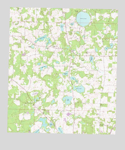
Cherry Lake, FL USGS Topographic Map
Click on map above to begin viewing in our Map Viewer.

This topographic map contains these locations and features:
Feature Name Type Latitude Longitude GNIS ID View Map
Architillery ChurchChurchN30.5400°W83.4289°277940View Map
Armstrong PondLakeN30.5312°W83.4310°277955View Map
Blair PondLakeN30.5859°W83.3867°278972View Map
Bonnet LakeLakeN30.5124°W83.4587°279222View Map
Caulk FlatsFlatN30.5635°W83.3965°280164View Map
Cherry LakePopulated PlaceN30.5833°W83.4271°294712View Map
Cherry LakeLakeN30.6152°W83.4149°280363View Map
Cherry Lake 4 H CampLocaleN30.6216°W83.4213°280365View Map
Cherry Lake ChurchChurchN30.5863°W83.4474°280366View Map
Cherry Lake Volunteer Fire DepartmentBuildingN30.6156°W83.4047°2644457View Map
Cobb PondLakeN30.5352°W83.4301°280597View Map
Devils WoodyardSwampN30.5225°W83.4968°281541View Map
Dobson PondLakeN30.5863°W83.4738°281622View Map
Duval PondLakeN30.5449°W83.4174°281899View Map
Elbow PondLakeN30.6045°W83.4389°282141View Map
Florid PondLakeN30.5547°W83.4241°282597View Map
Garden PondLakeN30.6099°W83.4275°282934View Map
Ginhouse PondLakeN30.5852°W83.4571°283093View Map
Hankins Sink PondLakeN30.5750°W83.4042°283690View Map
Harmony ChurchChurchN30.6244°W83.4907°283743View Map
Jestlamb SchoolSchoolN30.5097°W83.3918°284781View Map
Lime Sink SchoolSchoolN30.5124°W83.4482°285528View Map
Martin PondLakeN30.5033°W83.4383°286474View Map
Mile PondLakeN30.5656°W83.4600°286841View Map
Mount Zion ChurchChurchN30.5747°W83.4132°287357View Map
New Hopeful ChurchChurchN30.5299°W83.4777°287648View Map
Ocean HoleSwampN30.5395°W83.4712°288036View Map
Peddlers LakeLakeN30.5331°W83.4686°288654View Map
Peeler PondLakeN30.5915°W83.4539°288658View Map
Peeler PondLakeN30.5386°W83.4542°2437408View Map
Pine Grove ChurchChurchN30.5288°W83.3926°288847View Map
Pinegrove Baptist ChurchChurchN30.5285°W83.3928°2449665View Map
Plant PondLakeN30.5005°W83.4662°289023View Map
Rock Island PondLakeN30.5944°W83.4625°289830View Map
Rocky Ford Stolport (historical)AirportN30.5010°W83.3899°309635View Map
Rocky Springs ChurchChurchN30.5322°W83.4190°300912View Map
Saint Thomas ChurchChurchN30.5230°W83.4565°290401View Map
Wright PondLakeN30.5034°W83.4531°293544View Map

Note: Coordinates in the location and feature list above are referenced to NAD83 datum.


Copyright (C) 2008-2024 Ryan Niemi / Sunset Dynamics ... All Rights Reserved