TopoQuest Logo
Do you find TopoQuest useful?
Help keep TopoQuest running and adding new maps/features by donating!
Bitcoin:  19c7KJd3qBynnjoSw5npx9KScwjBe4ifkT
Litecoin:  LXs6TkuXGGXo1vDsWCkWVdjQX94eUKd6ui
Home View Maps Find Maps Find Places Resources & Links


Champlain, Virginia Topographic Map

USGS Map Title: Champlain, VA
USGS Map MRC: 38076A8
DRG (GeoTIFF) Download: o38076a8.tif


Neighboring USGS Topographic Map Quads:


  Rollins Fork, VA  
38077B1
 

  Colonial Beach South, VA  
38076B8
 

  Stratford Hall, VA  
38076B7
 

  Loretto, VA  
38077A1
 

  Champlain, VA  
38076A8
 

  Montross, VA  
38076A7
 

  Cauthornville, VA  
37077H1
 

  Mount Landing, VA  
37076H8
 

  Tappahannock, VA  
37076H7


Map MRC Location:

N39°
W77°
N39°
W76°
H8 H7 H6 H5 H4 H3 H2 H1
G8 G7 G6 G5 G4 G3 G2 G1
F8 F7 F6 F5 F4 F3 F2 F1
E8 E7 E6 E5 E4 E3 E2 E1
D8 D7 D6 D5 D4 D3 D2 D1
C8 C7 C6 C5 C4 C3 C2 C1
B8 B7 B6 B5 B4 B3 B2 B1
A8 A7 A6 A5 A4 A3 A2 A1
N38°
W77°
N38°
W76°

Champlain, VA USGS 1:24K Topographic Map Preview:
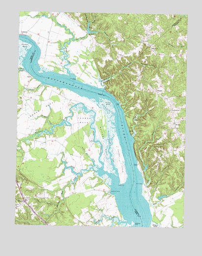
Champlain, VA USGS Topographic Map
Click on map above to begin viewing in our Map Viewer.

This topographic map contains these locations and features:
Feature Name Type Latitude Longitude GNIS ID View Map
Antioch ChurchChurchN38.0104°W76.9989°1462514View Map
Baird LandingLocaleN38.0493°W76.9419°1492503View Map
Bald Eagle HillSummitN38.0407°W76.8925°1492504View Map
Beaverdam CreekStreamN38.0974°W76.9116°1462956View Map
Beverly MarshSwampN38.0721°W76.9319°1463284View Map
Beverly Marsh CreekStreamN38.0662°W76.9280°1463285View Map
Blandfield PointCapeN38.0018°W76.9105°1463555View Map
Bottoms NeckCapeN38.0487°W76.9341°1463696View Map
Brick Hill CreekStreamN38.0337°W76.9377°1463801View Map
Bridge CreekStreamN38.0290°W76.9236°1463809View Map
Brockenbrough CreekStreamN38.0812°W76.9347°1463866View Map
Burnett CreekStreamN38.0137°W76.9008°1464123View Map
Carters WharfLocaleN38.0715°W76.9233°1464493View Map
Carters Wharf LandingLocaleN38.0715°W76.9239°1791296View Map
ChamplainPopulated PlaceN38.0135°W76.9927°1492742View Map
Champlain Post OfficePost OfficeN38.0119°W76.9913°2767204View Map
Chance Post Office (historical)Post OfficeN38.0751°W76.9966°1739420View Map
China HillPopulated PlaceN38.0929°W76.8816°1791299View Map
China HillSummitN38.0921°W76.8819°1791300View Map
China Hill Forks School (historical)SchoolN38.0926°W76.8816°1791301View Map
Clift CreekStreamN38.0721°W76.9239°1791303View Map
Colemans CreekStreamN38.0910°W76.9944°1465092View Map
Daingerfield LandingLocaleN38.0204°W76.9297°1492832View Map
Ephesus ChurchChurchN38.1096°W76.9083°1466330View Map
Farmers Hall CreekStreamN38.0321°W76.9391°1466494View Map
Fones CliffsCliffN38.0782°W76.9291°1466748View Map
FoneswoodPopulated PlaceN38.1049°W76.9011°1492952View Map
Foneswood School (historical)SchoolN38.1076°W76.9094°1791399View Map
Garlands CreekStreamN38.0529°W76.9133°1466998View Map
Handpole CreekStreamN38.0585°W76.9719°1467701View Map
HornersPopulated PlaceN38.1121°W76.9469°1493108View Map
Horners DamDamN38.1137°W76.9480°1491019View Map
Horners PondReservoirN38.1136°W76.9459°1502040View Map
Hundley DamDamN38.0301°W76.9547°1489635View Map
Hundley PondReservoirN38.0301°W76.9547°1489636View Map
Hutchinson SwampSwampN38.0813°W76.9838°1468438View Map
Island PointCapeN38.0249°W76.9233°1468540View Map
Jones CreekStreamN38.0271°W76.9052°1468837View Map
Jones LandingLocaleN38.0257°W76.9055°1493150View Map
Lawson NeckCapeN38.0685°W76.9808°1469215View Map
LaytonPopulated PlaceN38.0876°W76.9908°1493184View Map
Layton ReachChannelN38.0982°W76.9927°1480195View Map
LeedstownPopulated PlaceN38.1115°W76.9986°1493189View Map
Lindsay Hall FarmLocaleN38.0515°W76.9700°1739439View Map
Lukes IslandIslandN38.0562°W76.9141°1469934View Map
Lukes Island (historical)Populated PlaceN38.0568°W76.9025°1791323View Map
Malvale FarmLocaleN38.0746°W76.9714°1739442View Map
Margaret Lee SwampSwampN38.0315°W76.9524°1470089View Map
Marriner RunStreamN38.1243°W76.8772°1470102View Map
Mill SwampStreamN38.1093°W76.9602°1470547View Map
Mud Hole SwampStreamN38.0376°W76.9050°1471216View Map
Oak RowPopulated PlaceN38.0601°W76.8819°1493365View Map
Occupacia CreekStreamN38.0224°W76.9250°1471812View Map
Otterburn MarshSwampN38.0954°W76.9992°1471969View Map
Paynes IslandIslandN38.0393°W76.9219°1472134View Map
Pea RidgeRidgeN38.0490°W76.8983°1472143View Map
Peedee CreekStreamN38.0874°W76.9594°1472173View Map
PeedsPopulated PlaceN38.1007°W76.9225°1493409View Map
Rappahannock CemeteryCemeteryN38.0686°W76.8859°1791345View Map
Rappahannock ChurchChurchN38.0690°W76.8855°1472982View Map
Rouzie SwampStreamN38.0129°W76.9672°1473600View Map
Saint Mathews Church (historical)ChurchN38.0160°W76.9922°1739459View Map
SingerlyPopulated PlaceN38.0804°W76.8964°1474627View Map
Sluice CreekStreamN38.0032°W76.9147°1474703View Map
Smith Mount BranchStreamN38.1199°W76.9475°1474766View Map
Smith Mount HillSummitN38.1232°W76.9391°1791460View Map
Smith Mount LandingLocaleN38.0862°W76.9564°1493616View Map
Smoots LandingLocaleN38.0368°W76.9091°1493618View Map
Smoots Mill (historical)LocaleN38.1151°W76.9308°1791461View Map
Smoots Mill RunStreamN38.1135°W76.9414°1474788View Map
Smoots Pond (historical)ReservoirN38.1151°W76.9308°1791462View Map
Thomas NeckCapeN38.0618°W76.9502°1475648View Map
Waverly BranchStreamN38.1196°W76.9461°1476401View Map
Waverly HillSummitN38.1235°W76.9564°1791474View Map
Wilna CreekStreamN38.0137°W76.9008°1476807View Map

Note: Coordinates in the location and feature list above are referenced to NAD83 datum.


Copyright (C) 2008-2024 Ryan Niemi / Sunset Dynamics ... All Rights Reserved