TopoQuest Logo
Do you find TopoQuest useful?
Help keep TopoQuest running and adding new maps/features by donating!
Bitcoin:  19c7KJd3qBynnjoSw5npx9KScwjBe4ifkT
Litecoin:  LXs6TkuXGGXo1vDsWCkWVdjQX94eUKd6ui
Home View Maps Find Maps Find Places Resources & Links


Stratford Hall, Virginia Topographic Map

USGS Map Title: Stratford Hall, VA
USGS Map MRC: 38076B7
DRG (GeoTIFF) Download: o38076b7.tif


Neighboring USGS Topographic Map Quads:


  Colonial Beach North, VA  
38076C8
 

  Rock Point, MD  
38076C7
 

  Leonardtown, MD  
38076C6
 

  Colonial Beach South, VA  
38076B8
 

  Stratford Hall, VA  
38076B7
 

  Saint Clements Island, MD  
38076B6
 

  Champlain, VA  
38076A8
 

  Montross, VA  
38076A7
 

  Machodoc, VA  
38076A6


Map MRC Location:

N39°
W77°
N39°
W76°
H8 H7 H6 H5 H4 H3 H2 H1
G8 G7 G6 G5 G4 G3 G2 G1
F8 F7 F6 F5 F4 F3 F2 F1
E8 E7 E6 E5 E4 E3 E2 E1
D8 D7 D6 D5 D4 D3 D2 D1
C8 C7 C6 C5 C4 C3 C2 C1
B8 B7 B6 B5 B4 B3 B2 B1
A8 A7 A6 A5 A4 A3 A2 A1
N38°
W77°
N38°
W76°

Stratford Hall, VA USGS 1:24K Topographic Map Preview:
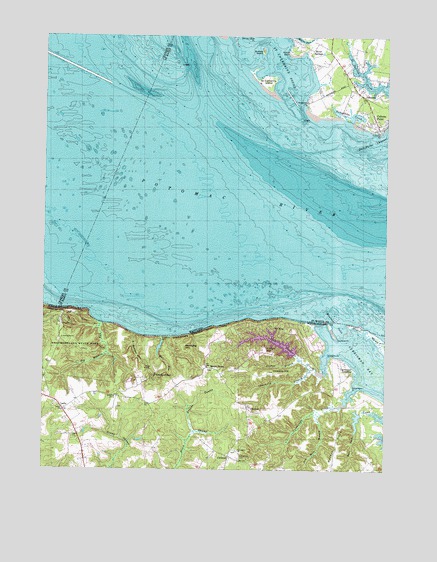
Stratford Hall, VA USGS Topographic Map
Click on map above to begin viewing in our Map Viewer.

This topographic map contains these locations and features:
Feature Name Type Latitude Longitude GNIS ID View Map
Asparagus PointCapeN38.1485°W76.7619°1462597View Map
Bettys NeckCapeN38.1326°W76.7672°1463259View Map
Big Meadow RunStreamN38.1674°W76.8539°1463382View Map
Big Meadow TrailTrailN38.1679°W76.8614°1463383View Map
Broadhurst Plantation (historical)LocaleN38.1410°W76.7580°1791373View Map
Bryant SwampStreamN38.1360°W76.8194°1463964View Map
Bryant TownPopulated PlaceN38.1543°W76.8147°1477152View Map
Bullock IslandIslandN38.2460°W76.7955°594614View Map
Chantilly BranchStreamN38.1540°W76.7769°1464738View Map
Chantilly HillSummitN38.1529°W76.7911°1499239View Map
ChiltonsPopulated PlaceN38.1290°W76.8064°1499256View Map
ChisfordPopulated PlaceN38.1429°W76.8000°1477202View Map
Clifton BranchStreamN38.1574°W76.7814°1464985View Map
Clifton HillSummitN38.1596°W76.7936°1499273View Map
Cobb Point Bar LighthouseLocaleN38.2418°W76.8250°1697500View Map
Cold Harbor CreekStreamN38.1585°W76.7711°1465063View Map
Coltons PointCapeN38.2229°W76.7522°594672View Map
Coltons PointPopulated PlaceN38.2246°W76.7533°594673View Map
Coltons Point Post OfficePost OfficeN38.2247°W76.7532°1697502View Map
Currioman Baptist Church CemeteryCemeteryN38.1283°W76.8029°1465545View Map
Currioman BayBayN38.1512°W76.7519°1465544View Map
Currioman CreekStreamN38.1482°W76.7611°1465546View Map
Currioman LandingPopulated PlaceN38.1543°W76.7614°1502785View Map
District 7, MilestownCivilN38.2422°W76.7823°1929673View Map
Dukeharts CreekBayN38.2276°W76.7633°594698View Map
EnfieldLocaleN38.2404°W76.7639°1697513View Map
Friendly HallLocaleN38.2337°W76.7539°1697710View Map
Gerard Chapel (historical)ChurchN38.2457°W76.7705°1697536View Map
Goodrich FarmLocaleN38.1457°W76.7550°1791401View Map
Grant ChurchChurchN38.1415°W76.8675°1467352View Map
Haulover InletBayN38.1676°W76.7680°594738View Map
Haulover InletGutN38.1674°W76.7677°1501628View Map
Haulover PointCapeN38.1624°W76.7664°1467833View Map
Hill School (historical)SchoolN38.1312°W76.8602°1791411View Map
Hollis MarshSwampN38.1622°W76.7524°1468147View Map
Horsehead CliffsCliffN38.1707°W76.8705°1468275View Map
Hummel VineyardsBuildingN38.1309°W76.8138°2518591View Map
Kentucky HillSummitN38.1604°W76.8239°1499619View Map
Kentucky RunStreamN38.1632°W76.8283°1791415View Map
Lake IndependenceReservoirN38.1619°W76.7905°1491018View Map
Lake Independence DamDamN38.1585°W76.7830°1491017View Map
LertyPopulated PlaceN38.1421°W76.8675°1477485View Map
Little HackleyLocaleN38.2396°W76.7727°1697586View Map
Little Meadow RunStreamN38.1637°W76.8408°1469590View Map
Mill RunStreamN38.1637°W76.8311°1470533View Map
Mount AirySummitN38.1660°W76.7861°1499045View Map
Mount Airy Wharf (historical)LocaleN38.1629°W76.7722°1791428View Map
Nomini CliffsCliffN38.1662°W76.8114°1471560View Map
Old Mill BranchStreamN38.1412°W76.7741°1471852View Map
PalmersPopulated PlaceN38.2337°W76.7575°594863View Map
Providence ChurchChurchN38.1307°W76.8039°1472835View Map
River SpringsPopulated PlaceN38.2462°W76.7775°594899View Map
Saint Agnes Chapel (historical)ChurchN38.2404°W76.7661°1697632View Map
Saint Catherine IslandIslandN38.2365°W76.7936°594911View Map
Saint Catherine SoundBayN38.2410°W76.7861°594912View Map
Saint Clements Island Historic DistrictParkN38.2237°W76.7525°1697637View Map
Shiloh Baptist Church CemeteryCemeteryN38.1457°W76.8486°1791458View Map
Shiloh ChurchChurchN38.1457°W76.8494°1474524View Map
Stratford CliffsCliffN38.1635°W76.8244°1475236View Map
Stratford HallPopulated PlaceN38.1515°W76.8344°1500179View Map
Stratford LandingLocaleN38.1637°W76.8308°1791465View Map
Stratford MillPopulated PlaceN38.1624°W76.8314°1500180View Map
Stratford MillpondReservoirN38.1603°W76.8321°1791466View Map
Turkey Neck TrailTrailN38.1585°W76.8577°1475950View Map
WaterlooPopulated PlaceN38.2312°W76.7791°1697689View Map
Waterloo PointCapeN38.2310°W76.7789°595006View Map
Waterloo Point BarBarN38.2271°W76.7786°1697690View Map
Westmoreland State ParkParkN38.1618°W76.8641°1476530View Map
Williams PointCapeN38.1582°W76.7702°1476767View Map
Yellow BankCapeN38.2460°W76.7850°595022View Map
Yellow Bank Point BarBarN38.2446°W76.7836°1697700View Map

Note: Coordinates in the location and feature list above are referenced to NAD83 datum.


Copyright (C) 2008-2024 Ryan Niemi / Sunset Dynamics ... All Rights Reserved