TopoQuest Logo
Do you find TopoQuest useful?
Help keep TopoQuest running and adding new maps/features by donating!
Bitcoin:  19c7KJd3qBynnjoSw5npx9KScwjBe4ifkT
Litecoin:  LXs6TkuXGGXo1vDsWCkWVdjQX94eUKd6ui
Home View Maps Find Maps Find Places Resources & Links


Hatfield, Missouri Topographic Map

USGS Map Title: Hatfield, MO
USGS Map MRC: 40094E2
DRG (GeoTIFF) Download: o40094e2.tif


Neighboring USGS Topographic Map Quads:


  Benton, IA  
40094F3
 

  Mount Ayr, IA  
40094F2
 

  Kellerton, IA  
40094F1
 

  Blockton SE, MO  
40094E3
 

  Hatfield, MO  
40094E2
 

  Pawnee, MO  
40094E1
 

  Allendale, MO  
40094D3
 

  Washington Center, MO  
40094D2
 

  Brooklyn, MO  
40094D1


Map MRC Location:

N41°
W95°
N41°
W94°
H8 H7 H6 H5 H4 H3 H2 H1
G8 G7 G6 G5 G4 G3 G2 G1
F8 F7 F6 F5 F4 F3 F2 F1
E8 E7 E6 E5 E4 E3 E2 E1
D8 D7 D6 D5 D4 D3 D2 D1
C8 C7 C6 C5 C4 C3 C2 C1
B8 B7 B6 B5 B4 B3 B2 B1
A8 A7 A6 A5 A4 A3 A2 A1
N40°
W95°
N40°
W94°

Hatfield, MO USGS 1:24K Topographic Map Preview:
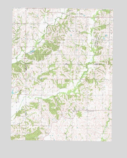
Hatfield, MO USGS Topographic Map
Click on map above to begin viewing in our Map Viewer.

This topographic map contains these locations and features:
Feature Name Type Latitude Longitude GNIS ID View Map
Baptist Church (historical)ChurchN40.6178°W94.1652°2061223View Map
Caledonia (historical)Populated PlaceN40.6244°W94.1619°466362View Map
Caledonia CemeteryCemeteryN40.6228°W94.1807°1822814View Map
Caledonia Post Office (historical)Post OfficeN40.6172°W94.1669°1969383View Map
Cottrel Lake DamDamN40.5433°W94.2486°760552View Map
East Fork Grand RiverStreamN40.5936°W94.2147°456145View Map
Green Hills Planning RegionCivilN40.5003°W94.1255°754101View Map
HatfieldPopulated PlaceN40.5289°W94.1550°719203View Map
Lincoln Center CemeteryCemeteryN40.5278°W94.1736°721078View Map
Long BranchStreamN40.5669°W94.1560°721503View Map
Lotts Grove ChurchChurchN40.5458°W94.2400°721605View Map
Marie LakeReservoirN40.5451°W94.2485°760553View Map
Methodist Episcopal Church (historical)ChurchN40.6175°W94.1647°2061224View Map
Oakdale CemeteryCemeteryN40.5879°W94.2338°1822815View Map
Petry CemeteryCemeteryN40.5225°W94.2380°724264View Map
Poyneer Post Office (historical)Post OfficeN40.6042°W94.2350°1969385View Map
RinggoldLocaleN40.5811°W94.1927°466364View Map
Ringgold (historical)Populated PlaceN40.5839°W94.1919°465445View Map
Ringgold CemeteryCemeteryN40.5880°W94.1928°1969453View Map
Ringgold Post Office (historical)Post OfficeN40.5839°W94.1919°1969384View Map
Ringgold State Wildlife AreaParkN40.5961°W94.1433°1822816View Map
ThomasLocaleN40.6103°W94.2241°466361View Map
Thomas Post Office (historical)Post OfficeN40.6103°W94.2241°1969387View Map
Township of LincolnCivilN40.5215°W94.1749°766724View Map
Township of Lotts CreekCivilN40.6056°W94.1865°468307View Map
Tuckers CreekStreamN40.6233°W94.1419°1822823View Map
Turkey Grove School (historical)SchoolN40.5578°W94.2041°727870View Map
WattersonPopulated PlaceN40.6019°W94.2336°464325View Map
Watterson Post Office (historical)Post OfficeN40.6019°W94.2336°1969386View Map
Watterson QuarryMineN40.5897°W94.2269°2628385View Map

Note: Coordinates in the location and feature list above are referenced to NAD83 datum.


Copyright (C) 2008-2024 Ryan Niemi / Sunset Dynamics ... All Rights Reserved