TopoQuest Logo
Do you find TopoQuest useful?
Help keep TopoQuest running and adding new maps/features by donating!
Bitcoin:  19c7KJd3qBynnjoSw5npx9KScwjBe4ifkT
Litecoin:  LXs6TkuXGGXo1vDsWCkWVdjQX94eUKd6ui
Home View Maps Find Maps Find Places Resources & Links


Whaleyville, Maryland Topographic Map

USGS Map Title: Whaleyville, MD
USGS Map MRC: 38075D3
DRG (GeoTIFF) Download: o38075d3.tif


Neighboring USGS Topographic Map Quads:


  Trap Pond, DE  
38075E4
 

  Millsboro, DE  
38075E3
 

  Frankford, DE  
38075E2
 

  Pittsville, MD  
38075D4
 

  Whaleyville, MD  
38075D3
 

  Selbyville, DE  
38075D2


  Berlin, MD  
38075C2


Map MRC Location:

N39°
W76°
N39°
W75°
H8 H7 H6 H5 H4 H3 H2 H1
G8 G7 G6 G5 G4 G3 G2 G1
F8 F7 F6 F5 F4 F3 F2 F1
E8 E7 E6 E5 E4 E3 E2 E1
D8 D7 D6 D5 D4 D3 D2 D1
C8 C7 C6 C5 C4 C3 C2 C1
B8 B7 B6 B5 B4 B3 B2 B1
A8 A7 A6 A5 A4 A3 A2 A1
N38°
W76°
N38°
W75°

Whaleyville, MD USGS 1:24K Topographic Map Preview:
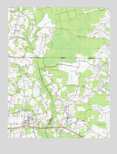
Whaleyville, MD USGS Topographic Map
Click on map above to begin viewing in our Map Viewer.

This topographic map contains these locations and features:
Feature Name Type Latitude Longitude GNIS ID View Map
Asherwood BranchStreamN38.3843°W75.3516°582940View Map
Asherwood Swamp (historical)SwampN38.3821°W75.3496°592468View Map
Bald Cypress BranchStreamN38.4657°W75.3471°213589View Map
Beaver HoleBayN38.4026°W75.3585°583108View Map
Bellfield DitchCanalN38.4276°W75.3146°583147View Map
BethelPopulated PlaceN38.4540°W75.3555°216031View Map
Bethel CemeteryCemeteryN38.4519°W75.3597°589036View Map
Bethel United Methodist ChurchChurchN38.4523°W75.3560°217385View Map
Big Newfound NeckCapeN38.4696°W75.3288°213659View Map
Burnt Mill BranchStreamN38.3818°W75.3282°583490View Map
Calvary Wesleyan ChurchChurchN38.4834°W75.3652°217402View Map
CareytownPopulated PlaceN38.4340°W75.3255°589896View Map
Careytown BranchStreamN38.4412°W75.3355°583590View Map
Cedar Swamp Farm and GreenhousesLocaleN38.4486°W75.2517°2651554View Map
Church of God of ProphecyChurchN38.4079°W75.3032°589029View Map
Costa Ventosa Winery and VineyardBuildingN38.4247°W75.2586°2704600View Map
Cypress SwampSwampN38.4834°W75.2996°213854View Map
Dale CemeteryCemeteryN38.4015°W75.3049°589035View Map
Davis DitchCanalN38.4284°W75.3455°584025View Map
Dennis CemeteryCemeteryN38.3805°W75.3568°589037View Map
District 14, WillardsCivilN38.3949°W75.3550°1929489View Map
Double Bridge BranchStreamN38.3751°W75.2880°582835View Map
Duncan CrossingPopulated PlaceN38.4034°W75.3057°1668739View Map
Eden Presbyterian ChurchChurchN38.3943°W75.3494°589032View Map
Gordys BranchStreamN38.3815°W75.3296°584666View Map
Grays ProngStreamN38.4854°W75.3388°216013View Map
Grays ProngCanalN38.4626°W75.3341°214022View Map
Green Branch School (historical)SchoolN38.4343°W75.3574°1668380View Map
Green RunStreamN38.4284°W75.3324°584749View Map
Gum BranchStreamN38.4657°W75.3471°214043View Map
GumboroPopulated PlaceN38.4776°W75.3652°216106View Map
Gumboro Fellowship ChurchChurchN38.4857°W75.3646°217384View Map
Gumboro United Methodist ChurchChurchN38.4796°W75.3641°217421View Map
Gumboro Volunteer Fire Company IncorporatedBuildingN38.4785°W75.3667°2610806View Map
Lewis NeckCapeN38.4712°W75.2824°214219View Map
Lewis ProngStreamN38.4754°W75.3419°217088View Map
Little Newfound NeckCapeN38.4834°W75.3444°214237View Map
LongridgePopulated PlaceN38.3907°W75.2805°590699View Map
Longridge BranchStreamN38.3865°W75.3016°585605View Map
Longridge SwampSwampN38.3880°W75.2600°585606View Map
Murray BranchStreamN38.4012°W75.3474°586119View Map
New HopePopulated PlaceN38.3909°W75.3352°590880View Map
New Hope CemeteryCemeteryN38.3960°W75.3277°589050View Map
New Hope ChurchChurchN38.3896°W75.3363°589031View Map
New Hope United Methodist ChurchChurchN38.3909°W75.3363°1668467View Map
Newhope Pond (historical)ReservoirN38.3880°W75.3386°1668468View Map
North Fork Green RunStreamN38.4371°W75.3527°214392View Map
Old Line DitchCanalN38.4473°W75.3007°586314View Map
Old Swamp Schoolhouse (historical)SchoolN38.4004°W75.3041°1668772View Map
ParkviewPopulated PlaceN38.3929°W75.3449°1668488View Map
Pine RidgeRidgeN38.4190°W75.3051°586522View Map
Pine Ridge BranchStreamN38.4101°W75.3188°586525View Map
Pine Ridge SwampSwampN38.4240°W75.2985°586526View Map
Pulletts ChapelChurchN38.4048°W75.3032°586721View Map
Pulletts Chapel CemeteryCemeteryN38.4045°W75.3030°1668781View Map
South Fork Green RunStreamN38.4371°W75.3527°587458View Map
Town of WillardsCivilN38.3921°W75.3494°2391486View Map
TwilleyPopulated PlaceN38.4501°W75.3519°1668566View Map
Twilley Family CemeteryCemeteryN38.4518°W75.3593°1668567View Map
Ukrainian Orthodox Trinity ChurchChurchN38.3959°W75.2988°589033View Map
WestwoodsPopulated PlaceN38.4951°W75.3716°216245View Map
WhaleyvillePopulated PlaceN38.3968°W75.3021°591697View Map
Whaleyville CemeteryCemeteryN38.3945°W75.3051°1668798View Map
Whaleyville Census Designated PlaceCensusN38.3911°W75.3000°2390501View Map
Whaleyville ParkParkN38.3998°W75.3049°1668799View Map
Whaleyville Post OfficePost OfficeN38.4001°W75.3042°1668800View Map
Whaleyville United Methodist ChurchChurchN38.3982°W75.3030°589030View Map
WillardsPopulated PlaceN38.3912°W75.3485°591557View Map
Willards Elementary SchoolSchoolN38.3940°W75.3565°2131866View Map
Willards Park and Recreation AreaParkN38.3940°W75.3432°589028View Map
Willards Post OfficePost OfficeN38.3954°W75.3522°1668611View Map
Willards SchoolSchoolN38.3901°W75.3524°589034View Map
Willards Town HallBuildingN38.3909°W75.3521°1668612View Map
Willards Volunteer Fire Department Station 8BuildingN38.3921°W75.3508°2087105View Map
WOCQ-FM (Berlin)TowerN38.3829°W75.3157°598463View Map
WQHQ-FM (Ocean City-Salisbury)TowerN38.3876°W75.2913°598494View Map

Note: Coordinates in the location and feature list above are referenced to NAD83 datum.


Copyright (C) 2008-2024 Ryan Niemi / Sunset Dynamics ... All Rights Reserved