TopoQuest Logo
Do you find TopoQuest useful?
Help keep TopoQuest running and adding new maps/features by donating!
Bitcoin:  19c7KJd3qBynnjoSw5npx9KScwjBe4ifkT
Litecoin:  LXs6TkuXGGXo1vDsWCkWVdjQX94eUKd6ui
Home View Maps Find Maps Find Places Resources & Links


Millsboro, Delaware Topographic Map

USGS Map Title: Millsboro, DE
USGS Map MRC: 38075E3
DRG (GeoTIFF) Download: o38075e3.tif


Neighboring USGS Topographic Map Quads:


  Georgetown, DE  
38075F4
 

  Harbeson, DE  
38075F3
 

  Fairmount, DE  
38075F2
 

  Trap Pond, DE  
38075E4
 

  Millsboro, DE  
38075E3
 

  Frankford, DE  
38075E2
 

  Pittsville, MD  
38075D4
 

  Whaleyville, MD  
38075D3
 

  Selbyville, DE  
38075D2


Map MRC Location:

N39°
W76°
N39°
W75°
H8 H7 H6 H5 H4 H3 H2 H1
G8 G7 G6 G5 G4 G3 G2 G1
F8 F7 F6 F5 F4 F3 F2 F1
E8 E7 E6 E5 E4 E3 E2 E1
D8 D7 D6 D5 D4 D3 D2 D1
C8 C7 C6 C5 C4 C3 C2 C1
B8 B7 B6 B5 B4 B3 B2 B1
A8 A7 A6 A5 A4 A3 A2 A1
N38°
W76°
N38°
W75°

Millsboro, DE USGS 1:24K Topographic Map Preview:
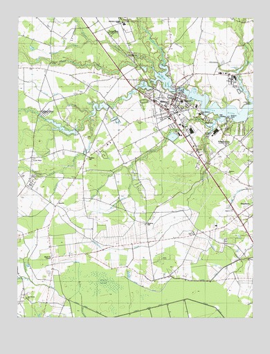
Millsboro, DE USGS Topographic Map
Click on map above to begin viewing in our Map Viewer.

This topographic map contains these locations and features:
Feature Name Type Latitude Longitude GNIS ID View Map
Askecksy (historical)AreaN38.5751°W75.3580°217191View Map
Bark PondReservoirN38.6043°W75.3119°213601View Map
Betts PondReservoirN38.5963°W75.3079°213650View Map
Burnt SwampSwampN38.5140°W75.3295°213730View Map
Burton AcresPopulated PlaceN38.5765°W75.2624°215412View Map
Carey CampLocaleN38.5584°W75.3669°213756View Map
Carey CemeteryCemeteryN38.5584°W75.3741°213758View Map
Carey ChurchChurchN38.5587°W75.3682°217357View Map
Careys Estate Mobile Home ParkPopulated PlaceN38.5534°W75.3680°216572View Map
Country Living Mobile Home ParkPopulated PlaceN38.5865°W75.3449°216616View Map
Cow BridgeLocaleN38.6065°W75.2988°216741View Map
Cow Bridge BranchStreamN38.6059°W75.2982°213544View Map
Cowhouse BranchStreamN38.5157°W75.3685°213840View Map
Cross KeysPopulated PlaceN38.5659°W75.3680°216076View Map
Cupola ParkParkN38.5943°W75.2894°217369View Map
Cypress Farms DitchCanalN38.5029°W75.3088°213852View Map
Dagsboro ChurchChurchN38.5454°W75.2596°215353View Map
Dagsboro Church of ChristChurchN38.5607°W75.2635°217362View Map
Dagsboro Church of GodChurchN38.5423°W75.2607°217361View Map
Dagsboro HundredCivilN38.5501°W75.2996°217207View Map
Delaware Colony State Training SchoolSchoolN38.6229°W75.3194°213874View Map
Delaware Veterans Memorial CemeteryCemeteryN38.6151°W75.3144°2773511View Map
Dickerson Chapel American Methodist Episcopal ChurchChurchN38.5693°W75.2807°217360View Map
East Millsboro Elementary SchoolSchoolN38.5855°W75.2793°214942View Map
Evans Park Mobile Home ParkPopulated PlaceN38.5346°W75.2816°216571View Map
Fishing PointCapeN38.5890°W75.2510°216740View Map
Forest Park Mobile Home ParkPopulated PlaceN38.6184°W75.3277°216617View Map
Grace United Methodist ChurchChurchN38.5901°W75.2910°217365View Map
Gumboro HundredCivilN38.5084°W75.3580°217261View Map
Hickory HillPopulated PlaceN38.5387°W75.3066°216111View Map
Hickory Hill ChurchChurchN38.5407°W75.3046°215354View Map
Holiday AcresPopulated PlaceN38.5723°W75.2655°216738View Map
Holiday EstatesPopulated PlaceN38.5312°W75.2652°215352View Map
Houston-Thorogood DitchStreamN38.5615°W75.3160°214129View Map
Ingram PondReservoirN38.5872°W75.3321°217371View Map
Ingram Pond (historical)SwampN38.5876°W75.3330°217414View Map
Iron BranchStreamN38.5798°W75.2716°214149View Map
Kerseys Evergreen AcresPopulated PlaceN38.5643°W75.2771°215356View Map
Lakeview EstatesPopulated PlaceN38.5765°W75.3430°215410View Map
Laurel DitchCanalN38.5154°W75.2841°214204View Map
Logwood PondLakeN38.6031°W75.2575°214245View Map
Long Drain DitchStreamN38.5912°W75.3185°214251View Map
Mid Sussex Shopping CenterLocaleN38.5778°W75.2830°2378973View Map
MillsboroPopulated PlaceN38.5915°W75.2913°214319View Map
Millsboro DivisionCivilN38.6118°W75.2820°1935618View Map
Millsboro Fire CompanyBuildingN38.5918°W75.2903°2610771View Map
Millsboro Police DepartmentBuildingN38.5921°W75.2914°2131087View Map
Millsboro PondReservoirN38.5994°W75.2974°214322View Map
Millsboro Post OfficePost OfficeN38.5890°W75.2923°2378970View Map
Millsboro Public LibraryBuildingN38.5941°W75.2961°2378968View Map
Millsboro Town HallBuildingN38.5864°W75.2909°2378971View Map
Millsboro Town Square Shopping CenterLocaleN38.5823°W75.2939°2378969View Map
Mirey BranchStreamN38.6046°W75.3032°217401View Map
MissionPopulated PlaceN38.5465°W75.3544°216158View Map
Narrow DrainStreamN38.6151°W75.3371°216735View Map
Nentego ManorPopulated PlaceN38.5154°W75.3605°215357View Map
New Holy Trinity Church of God in ChristChurchN38.5826°W75.2766°217358View Map
Oak DrivePopulated PlaceN38.5904°W75.3052°215413View Map
Old Field CemeteryCemeteryN38.5819°W75.3105°217367View Map
Old Field ChurchChurchN38.5818°W75.3102°214411View Map
Old LandingPopulated PlaceN38.5843°W75.2691°216168View Map
Order United American Men CemeteryCemeteryN38.5887°W75.2853°217368View Map
Pentecostal Church of GodChurchN38.6096°W75.3171°217363View Map
Pentecostal Holiness ChurchChurchN38.5871°W75.2849°217364View Map
Phillips DitchStreamN38.5848°W75.3349°214447View Map
Phillips HillPopulated PlaceN38.5690°W75.3330°216181View Map
Pine Lodge AdditionPopulated PlaceN38.5940°W75.3107°215414View Map
Pole Dam BridgeBridgeN38.6059°W75.3577°214471View Map
Possum PointCapeN38.5840°W75.2627°214480View Map
RiverviewPopulated PlaceN38.5826°W75.2746°216739View Map
Saint Luke Baptist ChurchChurchN38.5840°W75.2827°217359View Map
Saint Marks ChurchChurchN38.5918°W75.2932°215049View Map
Sandy BeachPopulated PlaceN38.5754°W75.2599°215411View Map
Shaft Ox CornerPopulated PlaceN38.5248°W75.3569°216211View Map
Sheep Pen DitchStreamN38.6040°W75.3035°214633View Map
Shoals BranchStreamN38.5843°W75.3366°217459View Map
Sunset BranchStreamN38.5604°W75.3513°216736View Map
Sussex Central Junior High SchoolSchoolN38.5887°W75.2874°214941View Map
Swan CreekStreamN38.5896°W75.2505°214712View Map
Tenfoot DitchCanalN38.5126°W75.3427°216737View Map
Town of MillsboroCivilN38.5866°W75.3018°2391304View Map
Town of Millsboro Sewage Treatment PlantLocaleN38.5892°W75.2839°2378376View Map
W B Atkins Memorial ParkParkN38.5926°W75.2960°217370View Map
Waples PondLakeN38.6060°W75.2536°214804View Map
Wesleyan ChurchChurchN38.5884°W75.2902°217366View Map
West Woods ChurchChurchN38.5079°W75.3702°217410View Map
Whartons BranchStreamN38.5826°W75.2688°214829View Map
Whartons DitchCanalN38.5293°W75.3110°214830View Map
Wiley Branch DitchStreamN38.5618°W75.3160°214849View Map

Note: Coordinates in the location and feature list above are referenced to NAD83 datum.


Copyright (C) 2008-2024 Ryan Niemi / Sunset Dynamics ... All Rights Reserved