TopoQuest Logo
Do you find TopoQuest useful?
Help keep TopoQuest running and adding new maps/features by donating!
Bitcoin:  19c7KJd3qBynnjoSw5npx9KScwjBe4ifkT
Litecoin:  LXs6TkuXGGXo1vDsWCkWVdjQX94eUKd6ui
Home View Maps Find Maps Find Places Resources & Links


Spesutie, Maryland Topographic Map

USGS Map Title: Spesutie, MD
USGS Map MRC: 39076D1
DRG (GeoTIFF) Download: o39076d1.tif


Neighboring USGS Topographic Map Quads:


  Aberdeen, MD  
39076E2
 

  Havre De Grace, MD  
39076E1
 

  North East, MD  
39075E8
 

  Perryman, MD  
39076D2
 

  Spesutie, MD  
39076D1
 

  Earleville, MD  
39075D8
 

  Hanesville, MD  
39076C2
 

  Betterton, MD  
39076C1
 

  Galena, MD  
39075C8


Map MRC Location:

N40°
W77°
N40°
W76°
H8 H7 H6 H5 H4 H3 H2 H1
G8 G7 G6 G5 G4 G3 G2 G1
F8 F7 F6 F5 F4 F3 F2 F1
E8 E7 E6 E5 E4 E3 E2 E1
D8 D7 D6 D5 D4 D3 D2 D1
C8 C7 C6 C5 C4 C3 C2 C1
B8 B7 B6 B5 B4 B3 B2 B1
A8 A7 A6 A5 A4 A3 A2 A1
N39°
W77°
N39°
W76°

Spesutie, MD USGS 1:24K Topographic Map Preview:
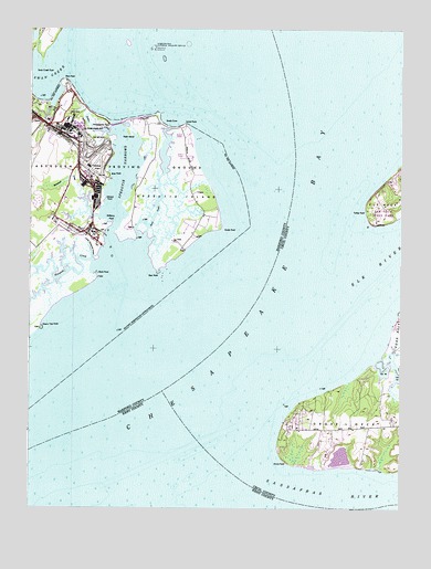
Spesutie, MD USGS Topographic Map
Click on map above to begin viewing in our Map Viewer.

This topographic map contains these locations and features:
Feature Name Type Latitude Longitude GNIS ID View Map
Back CreekStreamN39.4440°W76.0872°582978View Map
Battery IslandIslandN39.4946°W76.0830°595189View Map
Bear PointCapeN39.4371°W76.0816°583093View Map
Black PointCapeN39.4359°W76.1022°583264View Map
Brier PointCapeN39.4618°W76.0977°583389View Map
Cedar PointCapeN39.4934°W76.1250°583668View Map
Cherry Tree PointCapeN39.4223°W76.1211°583724View Map
Chesapeake HavenPopulated PlaceN39.3987°W76.0344°589156View Map
Chesapeake IsleLocaleN39.4612°W76.0024°595102View Map
CheshavenPopulated PlaceN39.3862°W76.0302°589160View Map
Cranberry FisheryLocaleN39.4104°W76.0136°589187View Map
Dipper CreekStreamN39.4726°W76.0977°584107View Map
Elk RiverStreamN39.4223°W76.0369°584276View Map
Fishing Battery LighthouseBuildingN39.4946°W76.0836°1698708View Map
Grove PointCapeN39.3871°W76.0377°584782View Map
Grove Point Disposal Area DamDamN39.3884°W76.0197°594465View Map
Grove Point Disposal Area LakeReservoirN39.3886°W76.0199°594466View Map
Grove Point Fishery (historical)LocaleN39.3859°W76.0330°589281View Map
Grove Point Girl Scout CampLocaleN39.3918°W76.0330°589282View Map
Grove Point Wildlife SanctuaryParkN39.3890°W76.0199°595106View Map
HazelmoorPopulated PlaceN39.4101°W76.0111°589294View Map
Johnson PointCapeN39.4559°W76.1000°585257View Map
Little Mosquito CreekStreamN39.4398°W76.1038°585492View Map
Locust PointCapeN39.4748°W76.0724°585543View Map
Money Land FisheryLocaleN39.4609°W76.0055°589374View Map
Mosquito CreekStreamN39.4379°W76.1016°585971View Map
Mulberry PointCapeN39.4496°W76.0972°586109View Map
Neds IslandIslandN39.4721°W76.0941°586157View Map
Plum PointCapeN39.4862°W76.1136°586608View Map
Pond CreekStreamN39.4140°W76.0074°586638View Map
Sands CoveBayN39.4757°W76.0772°587190View Map
Sandy PointCapeN39.4482°W76.0605°587211View Map
Sassafras RiverStreamN39.3873°W76.0536°214616View Map
Snug Harbor Boy Scout CampLocaleN39.3932°W76.0391°589512View Map
Spesutie IslandIslandN39.4559°W76.0766°587493View Map
Spesutie Island BridgeBridgeN39.4751°W76.0966°1698834View Map
Spesutie NarrowsChannelN39.4623°W76.0922°587494View Map
Susquehanna National Wildlife RefugeParkN39.4947°W76.0833°588933View Map
Swan CreekStreamN39.4943°W76.1052°587649View Map
Swan Creek PointCapeN39.4896°W76.1222°587651View Map
Turkey PointCapeN39.4526°W76.0113°587914View Map
Turkey Point LighthouseLocaleN39.4498°W76.0086°589562View Map
Woodpecker PointCapeN39.4751°W76.0977°588333View Map
Woodrest CreekStreamN39.4534°W76.0991°588334View Map

Note: Coordinates in the location and feature list above are referenced to NAD83 datum.


Copyright (C) 2008-2024 Ryan Niemi / Sunset Dynamics ... All Rights Reserved