TopoQuest Logo
Do you find TopoQuest useful?
Help keep TopoQuest running and adding new maps/features by donating!
Bitcoin:  19c7KJd3qBynnjoSw5npx9KScwjBe4ifkT
Litecoin:  LXs6TkuXGGXo1vDsWCkWVdjQX94eUKd6ui
Home View Maps Find Maps Find Places Resources & Links


Canton, New York Topographic Map

USGS Map Title: Canton, NY
USGS Map MRC: 44075E2
DRG (GeoTIFF) Download: o44075e2.tif


Neighboring USGS Topographic Map Quads:


  Lisbon, NY  
44075F3
 

  Morley, NY  
44075F2
 

  West Potsdam, NY  
44075F1
 

  Rensselaer Falls, NY  
44075E3
 

  Canton, NY  
44075E2
 

  Pierrepont, NY  
44075E1
 

  Bigelow, NY  
44075D3
 

  Hermon, NY  
44075D2
 

  West Pierrepont, NY  
44075D1


Map MRC Location:

N45°
W76°
N45°
W75°
H8 H7 H6 H5 H4 H3 H2 H1
G8 G7 G6 G5 G4 G3 G2 G1
F8 F7 F6 F5 F4 F3 F2 F1
E8 E7 E6 E5 E4 E3 E2 E1
D8 D7 D6 D5 D4 D3 D2 D1
C8 C7 C6 C5 C4 C3 C2 C1
B8 B7 B6 B5 B4 B3 B2 B1
A8 A7 A6 A5 A4 A3 A2 A1
N44°
W76°
N44°
W75°

Canton, NY USGS 1:24K Topographic Map Preview:
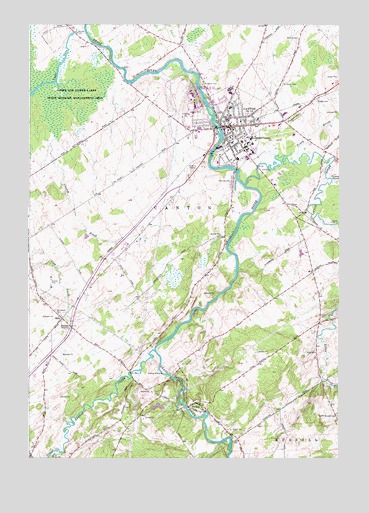
Canton, NY USGS Topographic Map
Click on map above to begin viewing in our Map Viewer.

This topographic map contains these locations and features:
Feature Name Type Latitude Longitude GNIS ID View Map
Abbott-Young Memorial TempleChurchN44.5933°W75.1625°2416797View Map
American TheatreBuildingN44.5953°W75.1694°2416786View Map
Benton Memorial LibraryBuildingN44.5950°W75.1689°2416787View Map
Boyden Brook Mobile Home ParkPopulated PlaceN44.5607°W75.2115°2599020View Map
Bridge CemeteryCemeteryN44.6034°W75.1341°976025View Map
Calvary Baptist ChurchChurchN44.5960°W75.1576°2599058View Map
CantonPopulated PlaceN44.5956°W75.1691°976078View Map
Canton Fire DepartmentBuildingN44.6022°W75.1774°2416783View Map
Canton Free LibraryBuildingN44.5950°W75.1692°2597617View Map
Canton Post OfficePost OfficeN44.5953°W75.1692°2598998View Map
Canton Rescue SquadBuildingN44.6023°W75.1772°2720105View Map
Canton Town HallBuildingN44.5950°W75.1711°2416785View Map
Cascade FallsFallsN44.5959°W75.1752°2788114View Map
Church BrookStreamN44.5920°W75.2391°976137View Map
Clark CemeteryCemeteryN44.5412°W75.1324°976140View Map
Clark's Trailer ParkPopulated PlaceN44.5626°W75.1371°2599021View Map
Country Meadows Trailer ParkPopulated PlaceN44.6133°W75.1820°2599022View Map
Crane Memorial Presbyterian Chapel (historical)ChurchN44.5164°W75.1861°2416798View Map
EddyPopulated PlaceN44.5401°W75.2366°976280View Map
Elm CreekStreamN44.5014°W75.2377°977221View Map
F S Banford Elementary SchoolSchoolN44.6053°W75.1686°2597935View Map
Fairview CemeteryCemeteryN44.5803°W75.1682°976303View Map
First Baptist ChurchChurchN44.5961°W75.1672°2416789View Map
First Methodist Episcopal ChurchChurchN44.5975°W75.1697°2416782View Map
First Presbyterian ChurchChurchN44.5947°W75.1678°2416791View Map
First Universalist ChurchChurchN44.5961°W75.1678°2416788View Map
Fullers FarmLocaleN44.5194°W75.1664°2559380View Map
Grace Episcopal ChurchChurchN44.5961°W75.1664°2416790View Map
Grannis BrookStreamN44.5798°W75.1280°976355View Map
H C Williams Senior High SchoolSchoolN44.6066°W75.1691°2597588View Map
Harrison CreekStreamN44.5312°W75.1997°975871View Map
Harts FallsFallsN44.5026°W75.1689°2788113View Map
Hurlbut FieldAirportN44.5452°W75.1605°977948View Map
Ideal Drive-In (historical)LocaleN44.5825°W75.1858°2557361View Map
J M McKenney Middle SchoolSchoolN44.6071°W75.1682°2597586View Map
Jerusalem CemeteryCemeteryN44.5428°W75.2394°976496View Map
King CemeteryCemeteryN44.5307°W75.1343°976523View Map
Little RiverStreamN44.5787°W75.1630°977234View Map
Little River Community SchoolSchoolN44.5312°W75.1346°2597932View Map
McCollum FarmLocaleN44.6067°W75.1306°2702696View Map
New Life Presbyterian ChurchChurchN44.6078°W75.1571°2597600View Map
North Russell CemeteryCemeteryN44.5125°W75.1258°976739View Map
Norton CemeteryCemeteryN44.6225°W75.2309°976742View Map
Oliver D Appleton Golf CourseLocaleN44.5919°W75.1503°2599055View Map
Partridge Run Golf and Country ClubLocaleN44.6164°W75.1688°2599052View Map
PyritesPopulated PlaceN44.5148°W75.1858°976860View Map
Pyrites Union Free School (historical)SchoolN44.5164°W75.1836°2416799View Map
Pyrites Volunteer Fire DepartmentBuildingN44.5148°W75.1858°2718264View Map
Rb Lawrence AmbulanceBuildingN44.5797°W75.1886°2720112View Map
Rushton FallsFallsN44.5967°W75.1746°975811View Map
Saint Lawrence County Court HouseBuildingN44.5989°W75.1689°2416795View Map
Saint Lawrence County Home (historical)BuildingN44.6100°W75.2083°2416792View Map
Saint Lawrence County JailBuildingN44.5986°W75.1686°2416796View Map
Saint Lawrence UniversitySchoolN44.5920°W75.1608°976940View Map
Saint Mary SchoolSchoolN44.6012°W75.1689°2597933View Map
Saint Mary's Roman Catholic ChurchChurchN44.6008°W75.1692°2416793View Map
Saint Mary's Roman Catholic ChurchChurchN44.5167°W75.1808°2416800View Map
Saint Mary's School (historical)SchoolN44.5967°W75.1697°2416784View Map
Saint Marys CemeteryCemeteryN44.6079°W75.1800°976942View Map
Saint Marys CemeteryCemeteryN44.6080°W75.1477°976943View Map
Second Adventist ChurchChurchN44.5994°W75.1694°2416794View Map
State University of New York College of Technology at CantonSchoolN44.6040°W75.1829°2784348View Map
Tanner CreekStreamN44.5020°W75.2372°975872View Map
Town of CantonCivilN44.5802°W75.1978°978789View Map
Tracy BrookStreamN44.5859°W75.1430°977131View Map
United Helpers Canton Nursing HomeBuildingN44.5953°W75.1816°2599040View Map
Upper LakeLakeN44.6045°W75.2494°977167View Map
Village of CantonCivilN44.6000°W75.1703°2391580View Map

Note: Coordinates in the location and feature list above are referenced to NAD83 datum.


Copyright (C) 2008-2024 Ryan Niemi / Sunset Dynamics ... All Rights Reserved