TopoQuest Logo
Do you find TopoQuest useful?
Help keep TopoQuest running and adding new maps/features by donating!
Bitcoin:  19c7KJd3qBynnjoSw5npx9KScwjBe4ifkT
Litecoin:  LXs6TkuXGGXo1vDsWCkWVdjQX94eUKd6ui
Home View Maps Find Maps Find Places Resources & Links


Melville, Louisiana Topographic Map

USGS Map Title: Melville, LA
USGS Map MRC: 30091F6
DRG (GeoTIFF) Download: o30091f6.tif


Neighboring USGS Topographic Map Quads:


  Bayou Current, LA  
30091G7
 

  Batchelor, LA  
30091G6
 

  Lacour, LA  
30091G5
 

  Swayze Lake, LA  
30091F7
 

  Melville, LA  
30091F6
 

  Morganza, LA  
30091F5
 

  Krotz Springs, LA  
30091E7
 

  Lottie, LA  
30091E6
 

  Fordoche, LA  
30091E5


Map MRC Location:

N31°
W92°
N31°
W91°
H8 H7 H6 H5 H4 H3 H2 H1
G8 G7 G6 G5 G4 G3 G2 G1
F8 F7 F6 F5 F4 F3 F2 F1
E8 E7 E6 E5 E4 E3 E2 E1
D8 D7 D6 D5 D4 D3 D2 D1
C8 C7 C6 C5 C4 C3 C2 C1
B8 B7 B6 B5 B4 B3 B2 B1
A8 A7 A6 A5 A4 A3 A2 A1
N30°
W92°
N30°
W91°

Melville, LA USGS 1:24K Topographic Map Preview:
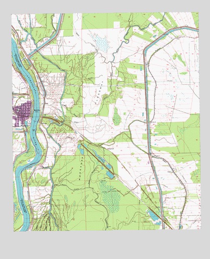
Melville, LA USGS Topographic Map
Click on map above to begin viewing in our Map Viewer.

This topographic map contains these locations and features:
Feature Name Type Latitude Longitude GNIS ID View Map
ArgylePopulated PlaceN30.6585°W91.6440°542935View Map
Argyle PlantationPopulated PlaceN30.6596°W91.6415°542149View Map
Bayou BallahackStreamN30.6496°W91.6990°553410View Map
Bayou Big SandyStreamN30.6332°W91.7259°532443View Map
Bayou BlackStreamN30.7219°W91.6843°553415View Map
Bayou Cross VineStreamN30.7219°W91.6843°553444View Map
Bayou DeepStreamN30.6360°W91.7265°532564View Map
Bayou LatenacheStreamN30.7327°W91.7337°553481View Map
Bayou Latenache Drainage CanalCanalN30.6305°W91.7223°532663View Map
Bayou Little SandyStreamN30.6360°W91.7259°532672View Map
Bayou Pays BasStreamN30.7421°W91.6709°553504View Map
Bayou ShermanStreamN30.6355°W91.7265°553526View Map
Bayou TommyStreamN30.6505°W91.7229°553532View Map
Bayou White VineStreamN30.7496°W91.6479°553538View Map
Cowhead BayouStreamN30.6974°W91.7254°554110View Map
Cross BayouStreamN30.6627°W91.7315°534273View Map
Emma Zion Baptist ChurchChurchN30.6982°W91.7377°2601592View Map
First Baptist ChurchChurchN30.6957°W91.7444°2601747View Map
First Pentecostal ChurchChurchN30.6909°W91.7439°2601970View Map
Flat BayouStreamN30.6941°W91.7115°534980View Map
Johnson BayouStreamN30.6605°W91.7248°554887View Map
Kingdom Hall of Jehovahs WitnessesChurchN30.6916°W91.7399°2602132View Map
MelvillePopulated PlaceN30.6930°W91.7440°1627636View Map
Melville CrevasseBasinN30.6869°W91.7412°1627637View Map
Melville Elementary SchoolSchoolN30.6858°W91.7441°552626View Map
Melville Head Start Center SchoolSchoolN30.6868°W91.7443°2600241View Map
Melville Police DepartmentBuildingN30.6930°W91.7444°2333931View Map
Melville Volunteer Fire DepartmentBuildingN30.6931°W91.7442°2691638View Map
Melville Wastewater Treatment FacilityLocaleN30.7000°W91.7495°2603473View Map
Morganza FloodwayFlatN30.7436°W91.6831°537214View Map
Morganza Gas FieldOilfieldN30.7224°W91.6440°546244View Map
Morris BayouStreamN30.7385°W91.7382°537232View Map
Mount Olive ChurchChurchN30.6874°W91.6582°537353View Map
Mussel BayouStreamN30.6605°W91.7248°555449View Map
Pointe Coupee Drainage StructureDamN30.7288°W91.7332°542161View Map
Prader BayouStreamN30.6982°W91.7179°538380View Map
RavenswoodPopulated PlaceN30.6721°W91.6896°555759View Map
Ravenswood Oil FieldOilfieldN30.6466°W91.6734°538506View Map
Red CrossLocaleN30.6874°W91.7307°555766View Map
Saint Landry Parish Police JuryBuildingN30.6912°W91.7441°2334143View Map
Town of MelvilleCivilN30.6917°W91.7484°2406144View Map
VivaPopulated PlaceN30.7352°W91.6404°543761View Map
Zion Traveler ChurchChurchN30.6674°W91.6568°540607View Map

Note: Coordinates in the location and feature list above are referenced to NAD83 datum.


Copyright (C) 2008-2024 Ryan Niemi / Sunset Dynamics ... All Rights Reserved