TopoQuest Logo
Do you find TopoQuest useful?
Help keep TopoQuest running and adding new maps/features by donating!
Bitcoin:  19c7KJd3qBynnjoSw5npx9KScwjBe4ifkT
Litecoin:  LXs6TkuXGGXo1vDsWCkWVdjQX94eUKd6ui
Home View Maps Find Maps Find Places Resources & Links


Swayze Lake, Louisiana Topographic Map

USGS Map Title: Swayze Lake, LA
USGS Map MRC: 30091F7
DRG (GeoTIFF) Download: o30091f7.tif


Neighboring USGS Topographic Map Quads:


  Bayou Jack, LA  
30091G8
 

  Bayou Current, LA  
30091G7
 

  Batchelor, LA  
30091G6
 

  Palmetto, LA  
30091F8
 

  Swayze Lake, LA  
30091F7
 

  Melville, LA  
30091F6
 

  Port Barre, LA  
30091E8
 

  Krotz Springs, LA  
30091E7
 

  Lottie, LA  
30091E6


Map MRC Location:

N31°
W92°
N31°
W91°
H8 H7 H6 H5 H4 H3 H2 H1
G8 G7 G6 G5 G4 G3 G2 G1
F8 F7 F6 F5 F4 F3 F2 F1
E8 E7 E6 E5 E4 E3 E2 E1
D8 D7 D6 D5 D4 D3 D2 D1
C8 C7 C6 C5 C4 C3 C2 C1
B8 B7 B6 B5 B4 B3 B2 B1
A8 A7 A6 A5 A4 A3 A2 A1
N30°
W92°
N30°
W91°

Swayze Lake, LA USGS 1:24K Topographic Map Preview:
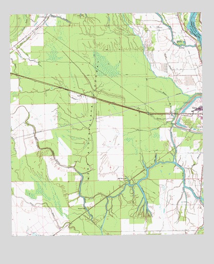
Swayze Lake, LA USGS Topographic Map
Click on map above to begin viewing in our Map Viewer.

This topographic map contains these locations and features:
Feature Name Type Latitude Longitude GNIS ID View Map
Bad BayouGutN30.6766°W91.7818°1628728View Map
Bad BayouStreamN30.6910°W91.7687°559808View Map
Bayou Ha HaStreamN30.6910°W91.7687°559978View Map
Bayou MiseryGutN30.6649°W91.7543°560034View Map
Bayou Petite PrairieStreamN30.6452°W91.7529°560049View Map
Bayou RougeStreamN30.7316°W91.7543°560070View Map
Big BayouStreamN30.7094°W91.8696°560164View Map
Blind BayouStreamN30.7119°W91.7698°560219View Map
Burtons LakeLakeN30.6774°W91.7698°560303View Map
Candy BayouGutN30.7435°W91.8648°560357View Map
Cow BayouStreamN30.7316°W91.8693°560504View Map
Evening Star Baptist ChurchChurchN30.6961°W91.7522°2601606View Map
GoodwoodPopulated PlaceN30.7307°W91.7640°560849View Map
Half Moon LakeLakeN30.6555°W91.7987°560928View Map
Hallf MoonPopulated PlaceN30.6557°W91.7979°1628731View Map
Hog BayouStreamN30.6888°W91.7701°560974View Map
Keith LakeLakeN30.6555°W91.7632°1627387View Map
Latenache Oil FieldOilfieldN30.6413°W91.7682°552619View Map
Loggy BayouGutN30.7363°W91.7732°1628737View Map
Majors AirparkAirportN30.6264°W91.7665°2656762View Map
Melville Gas FieldOilfieldN30.6485°W91.8001°1628738View Map
Negro Foot BayouStreamN30.7494°W91.8493°1627753View Map
Opelousas Club HouseBuildingN30.6613°W91.7873°1628740View Map
Purvis (historical)Populated PlaceN30.6652°W91.7826°1628742View Map
SamboPopulated PlaceN30.7041°W91.8284°1628167View Map
Sambo Gas FieldOilfieldN30.7024°W91.8251°552679View Map
Second LakeLakeN30.6428°W91.7885°1628197View Map
Second Lake (historical)Populated PlaceN30.6607°W91.7932°1628743View Map
Side LakeLakeN30.6674°W91.7809°1628229View Map
Swayze LakeLakeN30.6388°W91.8254°1628315View Map
Swayze LakePopulated PlaceN30.6402°W91.8268°1628316View Map
United Pentecostal ChurchChurchN30.7480°W91.8518°1628405View Map
Williamson (historical)Populated PlaceN30.6285°W91.8432°1628744View Map

Note: Coordinates in the location and feature list above are referenced to NAD83 datum.


Copyright (C) 2008-2024 Ryan Niemi / Sunset Dynamics ... All Rights Reserved