TopoQuest Logo
Do you find TopoQuest useful?
Help keep TopoQuest running and adding new maps/features by donating!
Bitcoin:  19c7KJd3qBynnjoSw5npx9KScwjBe4ifkT
Litecoin:  LXs6TkuXGGXo1vDsWCkWVdjQX94eUKd6ui
Home View Maps Find Maps Find Places Resources & Links


Lacomb, Oregon Topographic Map

USGS Map Title: Lacomb, OR
USGS Map MRC: 44122E6
DRG (GeoTIFF) Download: o44122e6.tif


Neighboring USGS Topographic Map Quads:


  Scio, OR  
44122F7
 

  Jordan, OR  
44122F6
 

  Snow Peak, OR  
44122F5
 

  Onehorse Slough, OR  
44122E7
 

  Lacomb, OR  
44122E6
 

  Keel Mountain, OR  
44122E5
 

  Waterloo, OR  
44122D7
 

  Sweet Home, OR  
44122D6
 

  Green Peter, OR  
44122D5


Map MRC Location:

N45°
W123°
N45°
W122°
H8 H7 H6 H5 H4 H3 H2 H1
G8 G7 G6 G5 G4 G3 G2 G1
F8 F7 F6 F5 F4 F3 F2 F1
E8 E7 E6 E5 E4 E3 E2 E1
D8 D7 D6 D5 D4 D3 D2 D1
C8 C7 C6 C5 C4 C3 C2 C1
B8 B7 B6 B5 B4 B3 B2 B1
A8 A7 A6 A5 A4 A3 A2 A1
N44°
W123°
N44°
W122°

Lacomb, OR USGS 1:24K Topographic Map Preview:
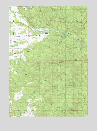
Lacomb, OR USGS Topographic Map
Click on map above to begin viewing in our Map Viewer.

This topographic map contains these locations and features:
Feature Name Type Latitude Longitude GNIS ID View Map
Billy CreekStreamN44.5018°W122.7243°1117708View Map
Church CreekStreamN44.6007°W122.6887°1118938View Map
Crabtree Guard StationLocaleN44.5951°W122.6876°1119490View Map
Deer CreekStreamN44.5410°W122.6993°1119815View Map
East Berlin School (historical)SchoolN44.5193°W122.7162°1120276View Map
Fords MillPopulated PlaceN44.5640°W122.7220°1136295View Map
Green MountainSummitN44.5590°W122.6468°1136337View Map
Green Mountain CreekStreamN44.5815°W122.6315°1121388View Map
Green Mountain School (historical)SchoolN44.5929°W122.7048°1121389View Map
Hammond CampLocaleN44.5926°W122.6873°1121546View Map
Hodges SpringSpringN44.5741°W122.7224°1134060View Map
Hoerauf ReservoirReservoirN44.6167°W122.7429°1134061View Map
Hunter CreekStreamN44.5976°W122.6756°1122148View Map
Jack CreekStreamN44.5073°W122.7209°1122324View Map
LacombPopulated PlaceN44.5851°W122.7434°1122880View Map
Lacomb CemeteryCemeteryN44.5726°W122.7418°1122881View Map
Lacomb Census Designated PlaceCensusN44.5844°W122.7417°2584418View Map
Lacomb Irrigation CanalCanalN44.5915°W122.6595°1122882View Map
Lacomb Post Office (historical)Post OfficeN44.5851°W122.7434°1165502View Map
Lacomb SchoolSchoolN44.5857°W122.7402°2466066View Map
Lebanon Fire District Station 32BuildingN44.5855°W122.7390°2576947View Map
Milky ForkStreamN44.6248°W122.7234°1131049View Map
Round MountainSummitN44.5615°W122.6673°1136710View Map
Scott CreekStreamN44.5260°W122.7131°1126684View Map
South Fork Beaver CreekStreamN44.5679°W122.7320°1127256View Map
South Fork Scott CreekStreamN44.5257°W122.7056°1127318View Map
Weddle Covered BridgeBridgeN44.5773°W122.7254°1955642View Map

Note: Coordinates in the location and feature list above are referenced to NAD83 datum.


Copyright (C) 2008-2024 Ryan Niemi / Sunset Dynamics ... All Rights Reserved