TopoQuest Logo
Do you find TopoQuest useful?
Help keep TopoQuest running and adding new maps/features by donating!
Bitcoin:  19c7KJd3qBynnjoSw5npx9KScwjBe4ifkT
Litecoin:  LXs6TkuXGGXo1vDsWCkWVdjQX94eUKd6ui
Home View Maps Find Maps Find Places Resources & Links


Cuba, New Mexico Topographic Map

USGS Map Title: Cuba, NM
USGS Map MRC: 36106A8
DRG (GeoTIFF) Download: o36106a8.tif


Neighboring USGS Topographic Map Quads:


  Five Lakes Canyon NE, NM  
36107B1
 

  Regina, NM  
36106B8
 

  Gallina, NM  
36106B7
 

  Arroyo Chijuillita, NM  
36107A1
 

  Cuba, NM  
36106A8
 

  Nacimiento Peak, NM  
36106A7
 

  Mesa Portales, NM  
35107H1
 

  San Pablo, NM  
35106H8
 

  Rancho del Chaparral, NM  
35106H7


Map MRC Location:

N37°
W107°
N37°
W106°
H8 H7 H6 H5 H4 H3 H2 H1
G8 G7 G6 G5 G4 G3 G2 G1
F8 F7 F6 F5 F4 F3 F2 F1
E8 E7 E6 E5 E4 E3 E2 E1
D8 D7 D6 D5 D4 D3 D2 D1
C8 C7 C6 C5 C4 C3 C2 C1
B8 B7 B6 B5 B4 B3 B2 B1
A8 A7 A6 A5 A4 A3 A2 A1
N36°
W107°
N36°
W106°

Cuba, NM USGS 1:24K Topographic Map Preview:
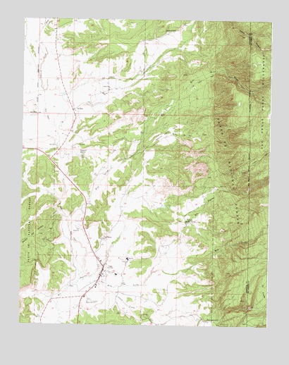
Cuba, NM USGS Topographic Map
Click on map above to begin viewing in our Map Viewer.

This topographic map contains these locations and features:
Feature Name Type Latitude Longitude GNIS ID View Map
A Montoya SpringSpringN36.0050°W106.9289°902599View Map
Arroyo San JoseStreamN36.0167°W106.9728°903414View Map
Bilterrera SpringSpringN36.0670°W106.9848°902611View Map
Brodrick SpringSpringN36.0545°W106.9711°902615View Map
Butler Brothers MineMineN36.0228°W106.9606°939838View Map
Camp ZiaLocaleN36.0564°W106.9037°904327View Map
Chalcocite MineMineN36.0022°W106.9059°939646View Map
Checkerboard Area Health SystemBuildingN36.0222°W106.9584°931371View Map
Checkerboard Area Health System LibraryBuildingN36.1222°W106.9584°929374View Map
Circle A RanchLocaleN36.0866°W106.9309°905166View Map
Cliff MineMineN36.0022°W106.9059°940107View Map
Copper City (historical)Populated PlaceN36.0020°W106.9123°902398View Map
Copper City MineMineN36.0022°W106.9059°940108View Map
CubaPopulated PlaceN36.0222°W106.9584°915817View Map
Cuba Community LibraryBuildingN36.0222°W106.9584°929998View Map
Cuba District Ranger OfficeLocaleN36.0109°W106.9684°899313View Map
Cuba Elementary SchoolSchoolN36.0222°W106.9584°914682View Map
Cuba Health CenterHospitalN36.0222°W106.9584°901321View Map
Cuba Health Center Medical ServicesBuildingN36.0137°W106.9665°2657604View Map
Cuba High SchoolSchoolN36.0222°W106.9584°914684View Map
Cuba Middle SchoolSchoolN36.0222°W106.9584°914683View Map
Cuba PitMineN36.0228°W106.9606°915631View Map
Cuba Police DepartmentBuildingN36.0130°W106.9620°2722615View Map
Cuba Post OfficePost OfficeN36.0222°W106.9584°938154View Map
Cuba Presbyterian CemeteryCemeteryN36.0222°W106.9584°931210View Map
Cuba Ranger StationLocaleN36.0392°W106.9700°905542View Map
Cuba Volunteer Fire DepartmentBuildingN36.0135°W106.9617°2657683View Map
Cuba Weather StationLocaleN36.1222°W106.9584°931773View Map
D Martinez SpringSpringN36.0508°W106.9181°902653View Map
Elena Number 6MineN36.0022°W106.9059°915607View Map
Eureka Mesa QuarryMineN36.0050°W106.9089°917735View Map
GarrisonPopulated PlaceN36.0481°W106.9306°936785View Map
Immaculate Conception SchoolSchoolN36.0222°W106.9584°934181View Map
Kit Carson Boy Scout CampLocaleN36.0578°W106.8995°927283View Map
La JaraPopulated PlaceN36.0878°W106.9748°907648View Map
La Jara CemeteryCemeteryN36.0878°W106.9748°931223View Map
La Jara Census Designated PlaceCensusN36.1055°W106.9419°2408505View Map
La Jara CreekStreamN36.0809°W106.9837°907655View Map
La Jara Post OfficePost OfficeN36.0880°W106.9755°938067View Map
La Jara SchoolSchoolN36.0947°W106.9598°907659View Map
La PlacitaPopulated PlaceN36.0353°W106.9587°907709View Map
Laguana Tio Andres TankReservoirN36.0605°W106.9981°899314View Map
Laguna BonitaLakeN36.0701°W106.9714°907764View Map
Martinez SpringSpringN36.0470°W106.9111°914323View Map
Nacimiento Copper MineMineN36.0228°W106.9606°915632View Map
Nacimiento CreekStreamN36.0042°W106.9798°909007View Map
New Mexico State Police Station District 5 CubaBuildingN36.0131°W106.9614°2722634View Map
Ojo Encino Day SchoolSchoolN36.0222°W106.9584°934177View Map
P Gurule SpringSpringN36.0486°W106.9375°914272View Map
PresbyterianChurchN36.0222°W106.9584°920402View Map
R D Phillips SpringSpringN36.0650°W106.9514°902629View Map
Rito AnastacioTrailN36.0778°W106.8839°910287View Map
Rito de los PinosStreamN36.0400°W106.9759°910272View Map
Rito de los UtesStreamN36.0717°W106.9420°910273View Map
Rito LecheStreamN36.0106°W106.9717°910304View Map
Rock Springs SchoolSchoolN36.0222°W106.9584°901388View Map
Salado CreekStreamN36.1222°W106.9895°910546View Map
Santos Ninos ChurchChurchN36.0964°W106.9564°910812View Map
Torreon Christian SchoolSchoolN36.0222°W106.9584°934180View Map
Upper La JaraPopulated PlaceN36.1206°W106.9228°911994View Map
V McCoy SpringSpringN36.0453°W106.9198°914282View Map
Vallecito de los PinosValleyN36.0789°W106.9267°912047View Map
Vallecito del Rio PuercoLocaleN36.0428°W106.9170°912048View Map
Village of CubaCivilN36.0122°W106.9696°2413545View Map
W Eastlake SpringSpringN36.0431°W106.9736°914264View Map

Note: Coordinates in the location and feature list above are referenced to NAD83 datum.


Copyright (C) 2008-2024 Ryan Niemi / Sunset Dynamics ... All Rights Reserved