TopoQuest Logo
Do you find TopoQuest useful?
Help keep TopoQuest running and adding new maps/features by donating!
Bitcoin:  19c7KJd3qBynnjoSw5npx9KScwjBe4ifkT
Litecoin:  LXs6TkuXGGXo1vDsWCkWVdjQX94eUKd6ui
Home View Maps Find Maps Find Places Resources & Links


Bouldin Island, California Topographic Map

USGS Map Title: Bouldin Island, CA
USGS Map MRC: 38121A5
DRG (GeoTIFF) Download: o38121a5.tif


Neighboring USGS Topographic Map Quads:


  Rio Vista, CA  
38121B6
 

  Isleton, CA  
38121B5
 

  Thornton, CA  
38121B4
 

  Jersey Island, CA  
38121A6
 

  Bouldin Island, CA  
38121A5
 

  Terminous, CA  
38121A4
 

  Brentwood, CA  
37121H6
 

  Woodward Island, CA  
37121H5
 

  Holt, CA  
37121H4


Map MRC Location:

N39°
W122°
N39°
W121°
H8 H7 H6 H5 H4 H3 H2 H1
G8 G7 G6 G5 G4 G3 G2 G1
F8 F7 F6 F5 F4 F3 F2 F1
E8 E7 E6 E5 E4 E3 E2 E1
D8 D7 D6 D5 D4 D3 D2 D1
C8 C7 C6 C5 C4 C3 C2 C1
B8 B7 B6 B5 B4 B3 B2 B1
A8 A7 A6 A5 A4 A3 A2 A1
N38°
W122°
N38°
W121°

Bouldin Island, CA USGS 1:24K Topographic Map Preview:
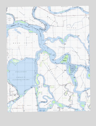
Bouldin Island, CA USGS Topographic Map
Click on map above to begin viewing in our Map Viewer.

This topographic map contains these locations and features:
Feature Name Type Latitude Longitude GNIS ID View Map
Beaver SloughGutN38.0308°W121.5433°1665983View Map
Blakes LandingLocaleN38.0633°W121.5469°1665985View Map
Bouldin IslandIslandN38.1041°W121.5347°219701View Map
Burns ReachChannelN38.0527°W121.5086°220219View Map
Central LandingLocaleN38.0999°W121.5636°1665990View Map
Columbia CutGutN38.0260°W121.5027°254766View Map
Connection SloughGutN38.0208°W121.5266°254770View Map
Criminal SloughGutN38.0741°W121.5397°1665992View Map
Hayes PointCapeN38.0680°W121.5608°227079View Map
Hayes ReachChannelN38.0752°W121.5711°225054View Map
Holland CutCanalN38.0149°W121.5813°225448View Map
Little Mandeville IslandIslandN38.0105°W121.5650°227300View Map
Little Venice IslandIslandN38.0505°W121.5013°227403View Map
Mandeville CutCanalN38.0563°W121.5402°228005View Map
Mandeville IslandIslandN38.0346°W121.5488°228006View Map
Mandeville PointCapeN38.0666°W121.5352°228007View Map
Mandeville ReachChannelN38.0566°W121.5338°228008View Map
Mandeville Tip County ParkParkN38.0613°W121.5386°228009View Map
Medford IslandIslandN38.0371°W121.5113°228475View Map
Middle RiverStreamN38.0419°W121.5266°228618View Map
Mokelumne RiverStreamN38.0960°W121.5700°228902View Map
Nibs SloughStreamN38.0424°W121.5322°1666007View Map
Old RiverStreamN38.0733°W121.5700°254998View Map
Potato PointCapeN38.0802°W121.5683°230985View Map
Potato SloughGutN38.0833°W121.5427°230986View Map
Prisoners PointCapeN38.0613°W121.5541°231064View Map
Prisoners Point Bend Light (historical)LocaleN38.0588°W121.5577°1662175View Map
Quimby IslandIslandN38.0252°W121.5713°231143View Map
Rhode IslandIslandN38.0005°W121.5744°231519View Map
Roosevelt CutCanalN38.0183°W121.6036°231848View Map
Sacramento County Sheriff - Brannan Island Service CenterBuildingN38.1016°W121.5675°2061437View Map
San Andreas ShoalBarN38.1008°W121.5850°232362View Map
Sand Mound SloughGutN38.0108°W121.6166°232505View Map
Sheep SloughGutN38.0205°W121.5805°232907View Map
Short SloughGutN38.0627°W121.6250°233053View Map
Singapore CutChannelN38.0638°W121.5372°252420View Map
Stockton Deep Water ChannelChannelN38.0560°W121.5261°235500View Map
Three River ReachChannelN38.0485°W121.5213°236315View Map
Turner Lake (historical)LakeN38.0294°W121.5586°1666012View Map
Turner Slough (historical)GutN38.0313°W121.5600°1666013View Map
Venice CutCanalN38.0555°W121.5244°237044View Map
Venice FerryLocaleN38.0608°W121.5019°237045View Map
Venice IslandIslandN38.0749°W121.5344°255193View Map
Venice ReachChannelN38.0630°W121.5427°237047View Map
Venice-Mandeville School (historical)SchoolN38.0074°W121.5313°1662176View Map
Ward IslandIslandN38.0416°W121.5025°255213View Map
Webb PointCapeN38.0921°W121.5794°237376View Map
Webb ReachChannelN38.0999°W121.5991°237377View Map
Webb TractCivilN38.0796°W121.6088°237379View Map

Note: Coordinates in the location and feature list above are referenced to NAD83 datum.


Copyright (C) 2008-2024 Ryan Niemi / Sunset Dynamics ... All Rights Reserved