TopoQuest Logo
Do you find TopoQuest useful?
Help keep TopoQuest running and adding new maps/features by donating!
Bitcoin:  19c7KJd3qBynnjoSw5npx9KScwjBe4ifkT
Litecoin:  LXs6TkuXGGXo1vDsWCkWVdjQX94eUKd6ui
Home View Maps Find Maps Find Places Resources & Links


Jersey Island, California Topographic Map

USGS Map Title: Jersey Island, CA
USGS Map MRC: 38121A6
DRG (GeoTIFF) Download: o38121a6.tif


Neighboring USGS Topographic Map Quads:


  Birds Landing, CA  
38121B7
 

  Rio Vista, CA  
38121B6
 

  Isleton, CA  
38121B5
 

  Antioch North, CA  
38121A7
 

  Jersey Island, CA  
38121A6
 

  Bouldin Island, CA  
38121A5
 

  Antioch South, CA  
37121H7
 

  Brentwood, CA  
37121H6
 

  Woodward Island, CA  
37121H5


Map MRC Location:

N39°
W122°
N39°
W121°
H8 H7 H6 H5 H4 H3 H2 H1
G8 G7 G6 G5 G4 G3 G2 G1
F8 F7 F6 F5 F4 F3 F2 F1
E8 E7 E6 E5 E4 E3 E2 E1
D8 D7 D6 D5 D4 D3 D2 D1
C8 C7 C6 C5 C4 C3 C2 C1
B8 B7 B6 B5 B4 B3 B2 B1
A8 A7 A6 A5 A4 A3 A2 A1
N38°
W122°
N38°
W121°

Jersey Island, CA USGS 1:24K Topographic Map Preview:
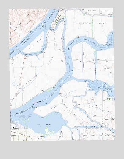
Jersey Island, CA USGS Topographic Map
Click on map above to begin viewing in our Map Viewer.

This topographic map contains these locations and features:
Feature Name Type Latitude Longitude GNIS ID View Map
Baldocchi LandingLocaleN38.0396°W121.7266°253393View Map
Bethel IslandIslandN38.0313°W121.6408°254611View Map
Bethel IslandPopulated PlaceN38.0149°W121.6405°1658045View Map
Bethel Island Census Designated PlaceCensusN38.0289°W121.6404°2407834View Map
Bethel Island Post OfficePost OfficeN38.0187°W121.6402°1701736View Map
Big BreakBayN38.0166°W121.7102°219137View Map
Big Break MarinaLocaleN38.0127°W121.7330°1701737View Map
Blind PointCapeN38.0321°W121.7197°219451View Map
Blumenberg (historical)Populated PlaceN38.0485°W121.7066°1666258View Map
Bradford IslandIslandN38.0771°W121.6633°219758View Map
Bradford LandingLocaleN38.0752°W121.6761°1682737View Map
Brannan Island State Recreation Area Visitor CenterBuildingN38.1105°W121.6972°1827024View Map
Brannon Island State Recreational AreaParkN38.1152°W121.6927°1666261View Map
Chinese CutBayN38.1035°W121.7261°221064View Map
Cottonwood CampgroundLocaleN38.1096°W121.6952°1827029View Map
Cypress Shopping CenterLocaleN38.0041°W121.7341°1701757View Map
Decker IslandIslandN38.0905°W121.7191°222145View Map
Decker LandingLocaleN38.0855°W121.7155°253389View Map
Delta Vista Berthing AreaHarborN38.1146°W121.6902°1827032View Map
Driftwood MarinaLocaleN38.0180°W121.7497°1701766View Map
Dutch SloughGutN38.0121°W121.6738°222779View Map
East Contra Costa Fire Protection District Station 95BuildingN38.0155°W121.6395°2623958View Map
Eddos HarborHarborN38.0499°W121.7038°253388View Map
EmmatonPopulated PlaceN38.0802°W121.7322°252671View Map
False RiverGutN38.0552°W121.6455°223379View Map
Fishermans CutCanalN38.0696°W121.6480°223550View Map
Fishermans SloughGutN38.0827°W121.6327°223552View Map
Fishermans Slough (historical)SwampN38.0805°W121.6372°1682741View Map
Franks Tract State Recreation AreaParkN38.0488°W121.6377°253869View Map
Gallagher SloughGutN38.0541°W121.6952°224013View Map
Gutman LandingLocaleN38.0335°W121.7361°1666290View Map
Horseshoe BendBendN38.0835°W121.7152°225639View Map
Jackass PointCapeN38.0474°W121.6538°226061View Map
Jersey Headquarters LandingLocaleN38.0449°W121.6922°253392View Map
Jersey IslandIslandN38.0363°W121.6858°226214View Map
Jersey PointCapeN38.0519°W121.6886°226215View Map
Larsen LandingLocaleN38.0977°W121.6686°1666301View Map
Lauritzen Yacht HarborHarborN38.0180°W121.7477°1701782View Map
Leisure LandingLocaleN38.0369°W121.6738°1701783View Map
Little Franks TractSwampN38.0499°W121.6511°1655066View Map
MackensonPopulated PlaceN38.1160°W121.6813°253386View Map
Marsh CreekStreamN38.0144°W121.6844°228132View Map
NoverdPopulated PlaceN38.0910°W121.6877°253385View Map
Oulton PointCapeN38.0899°W121.6366°230150View Map
Piper SloughGutN38.0416°W121.6305°230772View Map
Santa Clara ShoalBarN38.0896°W121.6466°232543View Map
Serpents SloughGutN38.0652°W121.6400°232814View Map
Sevenmile SloughGutN38.1177°W121.6500°232827View Map
Sherman IslandIslandN38.0594°W121.7333°232973View Map
Shima-Shima LandingLocaleN38.0444°W121.6586°253391View Map
Short Slough (historical)SwampN38.0583°W121.6288°1682747View Map
Taylor SloughGutN38.0294°W121.6677°236058View Map
The Island ClubLocaleN38.0224°W121.6352°1701826View Map
Threemile BridgeBridgeN38.1060°W121.7011°1827061View Map
Threemile SloughGutN38.1060°W121.6841°236328View Map
Toland LandingLocaleN38.0933°W121.7413°253390View Map
Twitchell IslandIslandN38.1096°W121.6486°236723View Map
Willow CampgroundLocaleN38.1127°W121.6930°1827070View Map

Note: Coordinates in the location and feature list above are referenced to NAD83 datum.


Copyright (C) 2008-2024 Ryan Niemi / Sunset Dynamics ... All Rights Reserved