TopoQuest Logo
Do you find TopoQuest useful?
Help keep TopoQuest running and adding new maps/features by donating!
Bitcoin:  19c7KJd3qBynnjoSw5npx9KScwjBe4ifkT
Litecoin:  LXs6TkuXGGXo1vDsWCkWVdjQX94eUKd6ui
Home View Maps Find Maps Find Places Resources & Links


Bishopville West, South Carolina Topographic Map

USGS Map Title: Bishopville West, SC
USGS Map MRC: 34080B3
DRG (GeoTIFF) Download: o34080b3.tif


Neighboring USGS Topographic Map Quads:


  Cassatt, SC  
34080C4
 

  Lucknow, SC  
34080C3
 

  Kellytown, SC  
34080C2
 

  Spring Hill, SC  
34080B4
 

  Bishopville West, SC  
34080B3
 

  Bishopville East, SC  
34080B2
 

  Dalzell, SC  
34080A4
 

  Oswego, SC  
34080A3
 

  Elliott, SC  
34080A2


Map MRC Location:

N35°
W81°
N35°
W80°
H8 H7 H6 H5 H4 H3 H2 H1
G8 G7 G6 G5 G4 G3 G2 G1
F8 F7 F6 F5 F4 F3 F2 F1
E8 E7 E6 E5 E4 E3 E2 E1
D8 D7 D6 D5 D4 D3 D2 D1
C8 C7 C6 C5 C4 C3 C2 C1
B8 B7 B6 B5 B4 B3 B2 B1
A8 A7 A6 A5 A4 A3 A2 A1
N34°
W81°
N34°
W80°

Bishopville West, SC USGS 1:24K Topographic Map Preview:
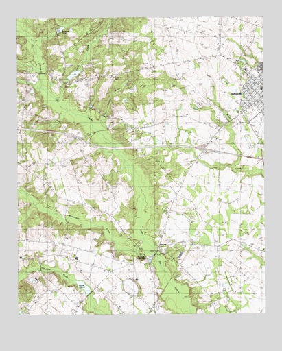
Bishopville West, SC USGS Topographic Map
Click on map above to begin viewing in our Map Viewer.

This topographic map contains these locations and features:
Feature Name Type Latitude Longitude GNIS ID View Map
Ashwood RacewayLocaleN34.1365°W80.3184°1242358View Map
Barnetteville ChurchChurchN34.1513°W80.3006°1244964View Map
Beaverdam CreekStreamN34.1524°W80.3056°1245025View Map
Benjamin ChurchChurchN34.2243°W80.3551°1246739View Map
Bens Industial Institute (historical)SchoolN34.2246°W80.2576°1236892View Map
Bethany ChurchChurchN34.1296°W80.2773°1246764View Map
Bethlehem CemeteriesCemeteryN34.2374°W80.2728°1220592View Map
Bishopville Church of GodChurchN34.2243°W80.2540°1236893View Map
Bishopville DivisionCivilN34.2270°W80.2801°1938200View Map
Bishopville Grammar School (historical)SchoolN34.2163°W80.2548°1236894View Map
Bishopville High SchoolSchoolN34.2279°W80.2526°1236896View Map
Bishopville Presbyterian ChurchChurchN34.2165°W80.2504°1236898View Map
Browntown ChurchChurchN34.2018°W80.3115°1221029View Map
Browntown School (historical)SchoolN34.2015°W80.3112°1236900View Map
Calvary ChurchChurchN34.2135°W80.3712°1247102View Map
Carters CrossingBridgeN34.1507°W80.3051°1236902View Map
Cedar CreekStreamN34.2163°W80.3562°1221438View Map
Cedar Creek ChurchChurchN34.2240°W80.3456°1247205View Map
Cedar Creek MillpondReservoirN34.2257°W80.3475°1221442View Map
Cedar Creek School (historical)SchoolN34.2227°W80.3459°1236903View Map
Church of the NazareneChurchN34.1274°W80.3242°1236906View Map
Dennis High SchoolSchoolN34.2282°W80.2528°1221998View Map
Denny PondReservoirN34.2335°W80.2581°1239681View Map
Denny Pond Dam D-1636DamN34.2335°W80.2581°1239680View Map
DuRant School (historical)SchoolN34.2313°W80.2954°1251802View Map
First Baptist ChurchChurchN34.2196°W80.2509°1236918View Map
Gum Springs BranchStreamN34.2038°W80.3342°1226848View Map
Gum Springs ChurchChurchN34.2263°W80.3251°1245861View Map
Gum Springs School (historical)SchoolN34.2243°W80.3265°1236920View Map
Hammetts CrossroadsPopulated PlaceN34.1493°W80.3095°1245890View Map
Hepsibah ChurchChurchN34.1540°W80.2965°1245960View Map
Hickory Hill School (historical)SchoolN34.1724°W80.3423°1236922View Map
Interchange 116CrossingN34.1946°W80.2804°1228165View Map
Jerusalem ChurchChurchN34.1718°W80.3426°1223568View Map
Jerusalem School (historical)SchoolN34.1713°W80.3417°1236924View Map
Johnsons PondReservoirN34.2452°W80.3528°1250904View Map
Laws BranchStreamN34.1882°W80.2656°1223843View Map
Lee CountyCivilN34.1633°W80.2545°1245652View Map
Lee County Emergency Medical ServicesBuildingN34.2279°W80.2588°2739593View Map
Lee County Memorial HospitalHospitalN34.2279°W80.2592°1247950View Map
Lee County Rural Fire Department Cedar CreekBuildingN34.2271°W80.3690°2578427View Map
Lee County Vacational SchoolSchoolN34.2252°W80.2517°1236928View Map
Liberty ChurchChurchN34.1971°W80.2529°1246352View Map
ManvillePopulated PlaceN34.1540°W80.3034°1246526View Map
Mary Lees PondReservoirN34.2119°W80.2841°1238266View Map
McCutchen (historical)Populated PlaceN34.1785°W80.2923°1236932View Map
McGrits MillpondReservoirN34.1368°W80.3416°1246595View Map
McLellan CemeteryCemeteryN34.1888°W80.2845°1224422View Map
New Haven ChurchChurchN34.1554°W80.3567°1249804View Map
New Haven School (historical)SchoolN34.1354°W80.3540°1236943View Map
Pate CemeteryCemeteryN34.2474°W80.3548°1225314View Map
Pate Chapel (historical)ChurchN34.2465°W80.3551°1245656View Map
Piedmont Baptist Church (historical)ChurchN34.2054°W80.2681°1706226View Map
Piedmont CemeteryCemeteryN34.2063°W80.2692°1225408View Map
Rose HillPopulated PlaceN34.1368°W80.3354°1236951View Map
Saint John African Methodist Episcopal ChurchChurchN34.2115°W80.2587°1236954View Map
Saint Mark School (historical)SchoolN34.1540°W80.2726°1236955View Map
Saint Marks ChurchChurchN34.1552°W80.2867°1250599View Map
Shekinah TabernacleChurchN34.2204°W80.2509°1236965View Map
Singletary MillpondReservoirN34.2435°W80.3548°1239490View Map
Singletary Millpond Dam D-2410DamN34.2449°W80.3545°1239489View Map
South Carolina Noname 31013 D-2407 DamDamN34.1346°W80.3387°1238255View Map
South Carolina Noname 31014 D-2411 DamDamN34.2252°W80.3498°1238257View Map
South Carolina Noname 31019 D-2415 DamDamN34.2118°W80.2831°1238265View Map
South Main Historic DistrictParkN34.2152°W80.2529°1236967View Map
SpurPopulated PlaceN34.1682°W80.2981°1236970View Map
Thomastown School (historical)SchoolN34.2065°W80.3179°1236972View Map
Whilden CemeteryCemeteryN34.1504°W80.3240°1227523View Map

Note: Coordinates in the location and feature list above are referenced to NAD83 datum.


Copyright (C) 2008-2024 Ryan Niemi / Sunset Dynamics ... All Rights Reserved