TopoQuest Logo
Do you find TopoQuest useful?
Help keep TopoQuest running and adding new maps/features by donating!
Bitcoin:  19c7KJd3qBynnjoSw5npx9KScwjBe4ifkT
Litecoin:  LXs6TkuXGGXo1vDsWCkWVdjQX94eUKd6ui
Home View Maps Find Maps Find Places Resources & Links


Kellytown, South Carolina Topographic Map

USGS Map Title: Kellytown, SC
USGS Map MRC: 34080C2
DRG (GeoTIFF) Download: o34080c2.tif


Neighboring USGS Topographic Map Quads:


  Bethune, SC  
34080D3
 

  Lake Robinson, SC  
34080D2
 

  Hartsville North, SC  
34080D1
 

  Lucknow, SC  
34080C3
 

  Kellytown, SC  
34080C2
 

  Hartsville South, SC  
34080C1
 

  Bishopville West, SC  
34080B3
 

  Bishopville East, SC  
34080B2
 

  Lamar, SC  
34080B1


Map MRC Location:

N35°
W81°
N35°
W80°
H8 H7 H6 H5 H4 H3 H2 H1
G8 G7 G6 G5 G4 G3 G2 G1
F8 F7 F6 F5 F4 F3 F2 F1
E8 E7 E6 E5 E4 E3 E2 E1
D8 D7 D6 D5 D4 D3 D2 D1
C8 C7 C6 C5 C4 C3 C2 C1
B8 B7 B6 B5 B4 B3 B2 B1
A8 A7 A6 A5 A4 A3 A2 A1
N34°
W81°
N34°
W80°

Kellytown, SC USGS 1:24K Topographic Map Preview:
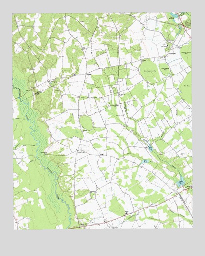
Kellytown, SC USGS Topographic Map
Click on map above to begin viewing in our Map Viewer.

This topographic map contains these locations and features:
Feature Name Type Latitude Longitude GNIS ID View Map
AlcotPopulated PlaceN34.2507°W80.1801°1227861View Map
Alcot School (historical)SchoolN34.2604°W80.1653°1236886View Map
AshlandPopulated PlaceN34.3399°W80.1981°1220250View Map
Ashland ChurchChurchN34.3393°W80.2053°1244933View Map
Ashland School (historical)SchoolN34.3346°W80.1998°1236888View Map
Beaverdam CreekStreamN34.3743°W80.1392°1245024View Map
Bell PondReservoirN34.2890°W80.1578°1220479View Map
Bells BranchStreamN34.2910°W80.2326°1220485View Map
Bethlehem CemeteryCemeteryN34.2943°W80.2265°1220596View Map
Bethlehem Church (historical)ChurchN34.2940°W80.2267°1245662View Map
Big Cypress BayBasinN34.3399°W80.1534°1220695View Map
Botany WoodsPopulated PlaceN34.3654°W80.1409°1240809View Map
Burnt BranchStreamN34.3004°W80.1542°1221141View Map
Clyde School (historical)SchoolN34.3732°W80.2126°1240835View Map
Ebenezer ChurchChurchN34.2585°W80.1717°1236912View Map
Ebenezer SchoolSchoolN34.2590°W80.1709°1222227View Map
Forest HillsPopulated PlaceN34.3688°W80.1267°1240871View Map
Galloway CemeteryCemeteryN34.2926°W80.1328°1222630View Map
Grantham CemeteryCemeteryN34.3154°W80.1726°1222819View Map
Gully RunStreamN34.2771°W80.1362°1222940View Map
Hebron ChurchChurchN34.2929°W80.1890°1245941View Map
Hebron School (historical)SchoolN34.2932°W80.1876°1236921View Map
Highpoint School (historical)SchoolN34.3010°W80.1478°1240888View Map
Jerusalem ChurchChurchN34.3213°W80.1790°1246169View Map
Kellybell ChurchChurchN34.3474°W80.1592°1246228View Map
Kellybell School (historical)SchoolN34.3474°W80.1601°1240901View Map
KellytownPopulated PlaceN34.3532°W80.1395°1231441View Map
Kellytown Baptist ChurchChurchN34.3490°W80.1434°1240902View Map
Kellytown CemeteryCemeteryN34.3490°W80.1442°1240903View Map
Kellytown School (historical)SchoolN34.3493°W80.1434°1240904View Map
Lee County Rural Fire Department Station 4BuildingN34.2955°W80.2038°2578827View Map
Lee County Rural Fire District Una AlcottBuildingN34.2537°W80.1848°2578572View Map
Liberty Hill CemeteryCemeteryN34.3271°W80.1753°1240914View Map
Liberty Hill ChurchChurchN34.3274°W80.1751°1246360View Map
Little Cypress BayBasinN34.3410°W80.1431°1223984View Map
Marco MillpondReservoirN34.2771°W80.1329°1238450View Map
Merchants Mill CreekStreamN34.2990°W80.2337°1246625View Map
Mount Beulah ChurchChurchN34.3352°W80.2192°1249546View Map
Mount Beulah School (historical)SchoolN34.3288°W80.2098°1236936View Map
Mount Elon CemeteryCemeteryN34.2749°W80.1259°1240928View Map
Mount Elon ChurchChurchN34.2743°W80.1253°1249569View Map
Mount Tema ChurchChurchN34.3196°W80.1256°1249690View Map
Mount Tema School (historical)SchoolN34.3196°W80.1256°1240931View Map
Rock Hill School (historical)SchoolN34.3577°W80.2251°1240967View Map
Sandy Bluff School (historical)SchoolN34.2718°W80.1967°1236962View Map
Savannah CemeteryCemeteryN34.3065°W80.2012°1706228View Map
Savannah ChurchChurchN34.3068°W80.2017°1250797View Map
Segars Mill (historical)LocaleN34.3727°W80.1340°1240988View Map
Segars Mill StreamStreamN34.3743°W80.1284°1226487View Map
Segars MillpondReservoirN34.3733°W80.1365°1250831View Map
Shady Grove ChurchChurchN34.2713°W80.1962°1250838View Map
Shannon HillPopulated PlaceN34.2515°W80.2040°1226534View Map
Shannon Hill ChurchChurchN34.2521°W80.2006°1236963View Map
Smith PondReservoirN34.2965°W80.1539°1226697View Map
South Carolina Noname 16003 D-3516 DamDamN34.2763°W80.1303°1238449View Map
South Carolina Noname 16031 D-3515 DamDamN34.3727°W80.1340°1238478View Map
South Carolina Noname 31001 D-2425 DamDamN34.2952°W80.1531°1238241View Map
Spiveys Ferry (historical)CrossingN34.3246°W80.2428°1236968View Map
Stokes BridgeLocaleN34.2957°W80.2045°1251049View Map
Stokes Bridge-Cypress Crossroads DivisionCivilN34.2561°W80.1750°1938431View Map
Turkey CreekStreamN34.3140°W80.2401°1227240View Map
UnaPopulated PlaceN34.2702°W80.1345°1231877View Map
West Hartsville SchoolSchoolN34.3557°W80.1412°1251387View Map
Westview CemeteryCemeteryN34.3535°W80.1328°1227509View Map

Note: Coordinates in the location and feature list above are referenced to NAD83 datum.


Copyright (C) 2008-2024 Ryan Niemi / Sunset Dynamics ... All Rights Reserved