TopoQuest Logo
Do you find TopoQuest useful?
Help keep TopoQuest running and adding new maps/features by donating!
Bitcoin:  19c7KJd3qBynnjoSw5npx9KScwjBe4ifkT
Litecoin:  LXs6TkuXGGXo1vDsWCkWVdjQX94eUKd6ui
Home View Maps Find Maps Find Places Resources & Links


Camp Lejeune, North Carolina Topographic Map

USGS Map Title: Camp Lejeune, NC
USGS Map MRC: 34077F3
DRG (GeoTIFF) Download: o34077f3.tif


Neighboring USGS Topographic Map Quads:


  Jacksonville North, NC  
34077G4
 

  Kellum, NC  
34077G3
 

  Stella, NC  
34077G2
 

  Jacksonville South, NC  
34077F4
 

  Camp Lejeune, NC  
34077F3
 

  Hubert, NC  
34077F2
 

  Sneads Ferry, NC  
34077E4
 

  New River Inlet, NC  
34077E3
 

  Browns Inlet, NC  
34077E2


Map MRC Location:

N35°
W78°
N35°
W77°
H8 H7 H6 H5 H4 H3 H2 H1
G8 G7 G6 G5 G4 G3 G2 G1
F8 F7 F6 F5 F4 F3 F2 F1
E8 E7 E6 E5 E4 E3 E2 E1
D8 D7 D6 D5 D4 D3 D2 D1
C8 C7 C6 C5 C4 C3 C2 C1
B8 B7 B6 B5 B4 B3 B2 B1
A8 A7 A6 A5 A4 A3 A2 A1
N34°
W78°
N34°
W77°

Camp Lejeune, NC USGS 1:24K Topographic Map Preview:
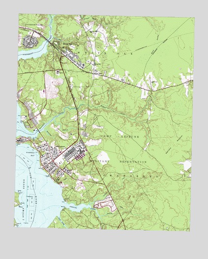
Camp Lejeune, NC USGS Topographic Map
Click on map above to begin viewing in our Map Viewer.

This topographic map contains these locations and features:
Feature Name Type Latitude Longitude GNIS ID View Map
Bearhead CreekStreamN34.6888°W77.3480°980749View Map
Beaverdam CreekStreamN34.6821°W77.3552°980834View Map
Berkeley Manor AreaPopulated PlaceN34.7091°W77.3494°1003127View Map
Brynn Marr HospitalHospitalN34.7465°W77.3744°2701518View Map
Calvary Lutheran ChurchChurchN34.7435°W77.3689°2505919View Map
Camp Geiger Post OfficePost OfficeN34.6727°W77.3600°2773833View Map
Camp Lejeune Fire DepartmentBuildingN34.6519°W77.3162°2639332View Map
Camp Lejeune Fire DepartmentBuildingN34.6709°W77.3380°2639335View Map
Camp Lejeune Fire DepartmentBuildingN34.7273°W77.3406°2639338View Map
Camp Lejeune Fire DepartmentBuildingN34.6757°W77.3539°2638395View Map
Camp Lejeune Post OfficePost OfficeN34.6602°W77.3412°2774251View Map
Camp Lejeune SchoolSchoolN34.7168°W77.3461°982540View Map
Cogdels CreekStreamN34.6479°W77.3408°983344View Map
Collins Estates Mobile Home ParkPopulated PlaceN34.7360°W77.3191°2505434View Map
Cowhead CreekStreamN34.6393°W77.3222°983651View Map
Duck CreekStreamN34.6332°W77.3436°984382View Map
Enon ChapelChurchN34.7177°W77.3200°984807View Map
Farnell BayBayN34.6682°W77.3608°985010View Map
First Baptist ChurchChurchN34.7079°W77.2792°2505823View Map
Frenchs CreekStreamN34.6391°W77.3394°985408View Map
Grey PointCapeN34.6268°W77.3722°986140View Map
Holiday City Mobile Home ParkPopulated PlaceN34.7436°W77.3582°2505608View Map
Holiday Mobile Home CityPopulated PlaceN34.7427°W77.3586°1003125View Map
Hubert Volunteer Fire DepartmentBuildingN34.7111°W77.2572°2638465View Map
James McDowell Jr Mobile Home ParkPopulated PlaceN34.7302°W77.3236°2505476View Map
Johnson Primary SchoolSchoolN34.6904°W77.3587°1003105View Map
Jumping RunStreamN34.6329°W77.3138°987815View Map
Kellumtown SchoolSchoolN34.7116°W77.2794°987901View Map
Lejeune High SchoolSchoolN34.7052°W77.3552°1003146View Map
Little Northeast CreekStreamN34.7479°W77.3508°988721View Map
Marshall Chapel Baptist ChurchChurchN34.7417°W77.3244°2505515View Map
Marshall Chapel SchoolSchoolN34.7407°W77.3236°989380View Map
Midville Baptist ChurchChurchN34.7398°W77.3585°2505521View Map
Midway ParkPopulated PlaceN34.7260°W77.3413°1021444View Map
Midway Park SchoolSchoolN34.7213°W77.3208°989835View Map
Mott CreekStreamN34.7366°W77.3500°990297View Map
Onslow County Emergency Medical Services Station 5BuildingN34.7111°W77.2572°2720468View Map
Pinewood DownsPopulated PlaceN34.7424°W77.3630°1003126View Map
Piney GreenPopulated PlaceN34.7160°W77.3202°992330View Map
Piney Green Volunteer Fire DepartmentBuildingN34.7216°W77.3209°2638287View Map
Ramseys Mobile Home ParkPopulated PlaceN34.7147°W77.2573°2505558View Map
Rhodes PointCapeN34.6388°W77.3705°993270View Map
Rocky RunStreamN34.7491°W77.3244°993625View Map
Spring BranchStreamN34.6952°W77.3719°1003149View Map
Spring PointCapeN34.6449°W77.3722°995358View Map
Starretts MeadowsFlatN34.6818°W77.2550°995429View Map
Tarawa Terrace IPopulated PlaceN34.7335°W77.3663°1003133View Map
Tarawa Terrace Post OfficePost OfficeN34.7319°W77.3743°2774182View Map
Tarawa Terrance Number 1 Elementary SchoolSchoolN34.7385°W77.3663°1003103View Map
Union ChapelChurchN34.7121°W77.3000°996426View Map
United States Naval Hospital Camp LejeuneHospitalN34.7227°W77.3581°1003159View Map
Wallace CreekStreamN34.6818°W77.3725°996722View Map
Watkins VillagePopulated PlaceN34.7027°W77.3508°1003128View Map
Weil PointCapeN34.6377°W77.3388°996929View Map
Whitehurst CreekStreamN34.6346°W77.3708°997231View Map
WJIK-AM (Camp Lejeune)TowerN34.7243°W77.3238°1018365View Map

Note: Coordinates in the location and feature list above are referenced to NAD83 datum.


Copyright (C) 2008-2024 Ryan Niemi / Sunset Dynamics ... All Rights Reserved