TopoQuest Logo
Do you find TopoQuest useful?
Help keep TopoQuest running and adding new maps/features by donating!
Bitcoin:  19c7KJd3qBynnjoSw5npx9KScwjBe4ifkT
Litecoin:  LXs6TkuXGGXo1vDsWCkWVdjQX94eUKd6ui
Home View Maps Find Maps Find Places Resources & Links


Bailey, Colorado Topographic Map

USGS Map Title: Bailey, CO
USGS Map MRC: 39105D4
DRG (GeoTIFF) Download: o39105d4.tif


Neighboring USGS Topographic Map Quads:


  Harris Park, CO  
39105E5
 

  Meridian Hill, CO  
39105E4
 

  Conifer, CO  
39105E3
 

  Shawnee, CO  
39105D5
 

  Bailey, CO  
39105D4
 

  Pine, CO  
39105D3
 

  Topaz Mountain, CO  
39105C5
 

  Windy Peak, CO  
39105C4
 

  Green Mountain, CO  
39105C3


Map MRC Location:

N40°
W106°
N40°
W105°
H8 H7 H6 H5 H4 H3 H2 H1
G8 G7 G6 G5 G4 G3 G2 G1
F8 F7 F6 F5 F4 F3 F2 F1
E8 E7 E6 E5 E4 E3 E2 E1
D8 D7 D6 D5 D4 D3 D2 D1
C8 C7 C6 C5 C4 C3 C2 C1
B8 B7 B6 B5 B4 B3 B2 B1
A8 A7 A6 A5 A4 A3 A2 A1
N39°
W106°
N39°
W105°

Bailey, CO USGS 1:24K Topographic Map Preview:
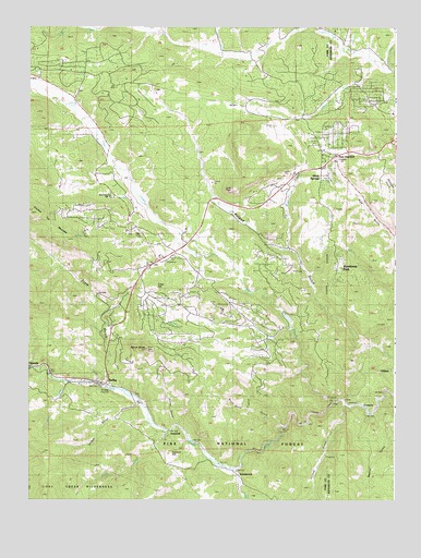
Bailey, CO USGS Topographic Map
Click on map above to begin viewing in our Map Viewer.

This topographic map contains these locations and features:
Feature Name Type Latitude Longitude GNIS ID View Map
BaileyPopulated PlaceN39.4055°W105.4733°204727View Map
Bailey Camp GroundsLocaleN39.4036°W105.4900°183278View Map
Bailey Post OfficePost OfficeN39.4056°W105.4779°2750856View Map
Bailey Ranger StationLocaleN39.4072°W105.4753°183277View Map
Beaver GulchValleyN39.3986°W105.3818°183264View Map
Black Mountain CreekStreamN39.4925°W105.3872°182531View Map
Brush GulchValleyN39.3989°W105.4254°183268View Map
CliffdalePopulated PlaceN39.4086°W105.3764°183266View Map
Cliffdale Post Office (historical)Post OfficeN39.4086°W105.3764°2026934View Map
Colorado State Patrol Bailey Office Post 3BuildingN39.4071°W105.4736°2696672View Map
Corbin GulchValleyN39.4004°W105.4635°183275View Map
Craig CreekStreamN39.3833°W105.4297°183241View Map
CrossonsPopulated PlaceN39.3992°W105.3864°183265View Map
Crow CreekStreamN39.4042°W105.4742°183222View Map
Crow GulchValleyN39.4051°W105.4734°183280View Map
Crow HillSummitN39.4317°W105.4566°183289View Map
Davis RanchLocaleN39.4933°W105.3914°183249View Map
Day RanchLocaleN39.4436°W105.4478°183288View Map
Deep GulchValleyN39.3943°W105.4144°183267View Map
Deer CreekStreamN39.4005°W105.3967°183244View Map
Dry Creek SchoolSchoolN39.4425°W105.4619°183290View Map
Earley RanchLocaleN39.4930°W105.4247°183257View Map
Elk Creek Fire / Rescue Station 2BuildingN39.4721°W105.4025°2368778View Map
EstabrookPopulated PlaceN39.3830°W105.4294°183269View Map
Fitzsimmons RanchLocaleN39.4233°W105.4519°183287View Map
Glen Isle Point CemeteryCemeteryN39.4086°W105.4950°2514169View Map
Hallack MineMineN39.4805°W105.4425°1703734View Map
Holmes GulchValleyN39.4005°W105.3917°183263View Map
Horn CemeteryCemeteryN39.4440°W105.4441°183285View Map
InsmontPopulated PlaceN39.3919°W105.4531°183271View Map
Insmont HillSummitN39.3872°W105.4521°183272View Map
Insmont Post Office (historical)Post OfficeN39.3919°W105.4531°2026921View Map
Isham Jones RanchLocaleN39.4853°W105.3900°183250View Map
Jones CreekStreamN39.4908°W105.3806°183260View Map
Lone RockSummitN39.4574°W105.4307°183284View Map
Lydia RanchLocaleN39.4872°W105.4975°183259View Map
Mason CreekStreamN39.4883°W105.3769°183246View Map
McCarthy RanchLocaleN39.4208°W105.4364°183286View Map
Mount BaileySummitN39.4152°W105.4598°183276View Map
North Elk CreekStreamN39.4989°W105.4086°183247View Map
Osirio MineMineN39.3917°W105.3978°1703733View Map
Park County Sheriff's Office Bailey SubstationBuildingN39.4078°W105.4896°2696604View Map
Parmalee Ditch 2 and 3CanalN39.4712°W105.4624°2723989View Map
Peterson RanchLocaleN39.4008°W105.4606°183274View Map
Pine Gulch CemeteryCemeteryN39.4610°W105.3975°183254View Map
Pine Gulch SchoolSchoolN39.4647°W105.3967°183253View Map
Pine JunctionPopulated PlaceN39.4661°W105.3958°2047155View Map
Pine Post OfficePost OfficeN39.4668°W105.3987°2047156View Map
Platte Canyon Fire Protection District Station 1BuildingN39.4066°W105.4822°2667184View Map
Platte Canyon Fire Protection District Station 2BuildingN39.4368°W105.4610°2036512View Map
Potter RanchLocaleN39.4978°W105.4611°183258View Map
Quiner GulchValleyN39.3942°W105.4506°183270View Map
Roark CreekStreamN39.4061°W105.4872°183279View Map
Rock CreekStreamN39.3930°W105.4531°183273View Map
Rosemont RanchLocaleN39.4667°W105.3844°183252View Map
Ruble Claims MineMineN39.4086°W105.4072°1703735View Map
Shaffer RanchLocaleN39.4511°W105.3997°183282View Map
Shott Brothers RanchLocaleN39.4764°W105.4086°183251View Map
Silver SpringsPopulated PlaceN39.4592°W105.3961°183255View Map
Wandcrest ParkPopulated PlaceN39.4355°W105.3939°183281View Map
Will-O-The-WispPopulated PlaceN39.4614°W105.4103°183256View Map
Wisp CreekStreamN39.4408°W105.4119°183283View Map

Note: Coordinates in the location and feature list above are referenced to NAD83 datum.


Copyright (C) 2008-2024 Ryan Niemi / Sunset Dynamics ... All Rights Reserved